
It’s amazing what you can see in a single image from the VIIRS Day/Night Band.
OK, so you can’t actually see any bears with VIIRS (even bears that have fattened up for the winter are less than 375 m across – and certainly less than the 742 m resolution of the Day/Night Band), but you can see auroras and volcanoes. And a lot more! Take a look at this image from the VIIRS Day/Night Band (DNB) taken at 12:19 UTC 7 October 2013:
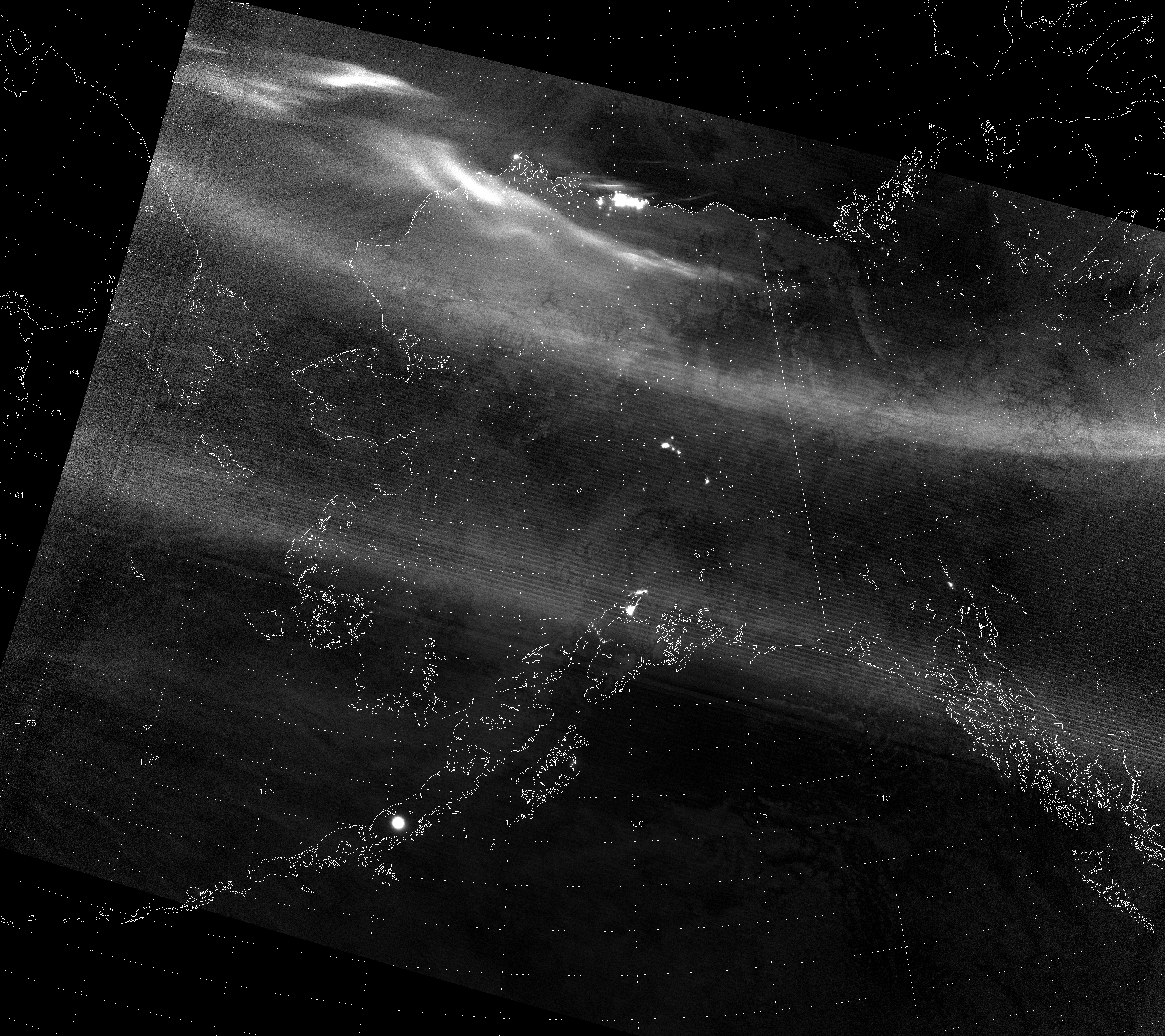
What do you see? Make sure you click on it to see the full resolution image.
Well, there’s a bright arc that stretches from Siberia, over the Brooks Range in northern Alaska and into the Yukon and Northwest Territories of Canada, and there are even brighter arcs north of that (between the Brooks Range and Barrow, even extending over the Arctic Ocean). Those are examples of the aurora borealis (a.k.a. Northern Lights).
As an aside, did you know that VIIRS can provide information about the speed of the aurora? I’ll wait if you want to read that. The aurora in this case is moving more in the along-track direction than the across-track direction, so the method for calculating the speed of the aurora won’t work so well with this aurora. Although, there does seem to be some apparent motion of the auroral element immediately off the coast from Prudhoe Bay. See if you can spot the scan-to-scan “shifts”.
Speaking of Prudhoe Bay, you can also see the tremendous amount of light given off by the oil and gas operations there, making the area look like the largest city in Alaska. (Compare the size of the lit-up area with that of Anchorage, which actually is the largest city in Alaska.) If you know your Alaska and Yukon geography, you should also be able to pick out Barrow, Fairbanks, Delta Junction, Whitehorse, Wasilla, Kodiak and Juneau.
Now, what is that big, circular city over the Alaska Peninsula? (It also looks bigger than Anchorage.) That is the volcano Veniaminof, which was erupting last time we looked at it (at the end of August), and appears to still be going strong as of 7 October 2013 (or it calmed down in the meantime before acting up again, as this article suggests). It’s not that the volcano is actually larger than the city of Anchorage, as it appears. What you are seeing is the light emitted by the liquid-phase rock erupting from the volcano. Rock that is hot enough to be liquid is hot enough to emit radiation in the visible and near-infrared wavelengths the Day/Night Band is sensitive to. This light is illuminating a circular area of the clouds surrounding Veniaminof, and enough of it is reflected or scattered to outer space that VIIRS is able to detect it.
Another question you might ask is, “What is that bright band across the image that parallels the scan lines and passes over both Anchorage and Juneau?” It almost looks like an aurora, but it is in too straight a line. It is another example of “stray light”. Now, if you read the previous post (and remember what it said) you might be confused, because I said that stray light was fixed and shouldn’t be a problem anymore. Well, the stray light correction is not perfect, especially in near-new moon images such as this. For example, say that the stray light correction introduces an error in the radiance on the order of 1 x 10⁻¹⁰ W cm-2. During a full moon, the radiance value observed for a clear background surface pixel would be on the order of 1 x 10⁻⁷ W cm-2, so this error is too small to notice (0.1 % error). During a new moon, the radiance values of a clear background surface are more like 5 x 10⁻¹⁰ W cm-2 (20% error, which is noticeable).
Another thing to consider is that the stray light correction requires post-processing, and is dependent on the moon’s phase and time of year. Since this image was near new moon in October (13% of full on the 7th), it uses data from the previous new moon (in September) to do the stray light correction, since we didn’t have a similar data from October to use. (Of course, we have that data now, but it wasn’t available at the time this image came off the satellite. It will be used on next year’s October data.) Slight differences in the solar-satellite geometry between September and October are the largest source of error in the stray light correction. Since the stray light correction began in late August 2013, once we get to September 2014 the stray light correction ought to perform much better (but it will still be more likely to show errors during a new moon than a full moon).
Speaking of this being near a new moon, how is it possible that you can see clouds and sea ice and snow? It’s true that the aurora does a good job illuminating the surface underneath, but the aurora doesn’t cover everywhere. What about over the ocean? There are no city lights, no erupting volcanoes, and not enough ships in the sea to light up the sky (like there are off the coast of Korea). Where is the light coming from?
It’s actually a phenomenon known as “airglow” (or “nightglow”, since it is easiest to detect at night). The shortened version is that molecules in the upper atmosphere interact with ultraviolet radiation and, as a result, emit photons. This happens around the clock. Airglow is enough to detect a Super Cyclone at night with no moon. That means, even on the darkest nights, the Day/Night Band is capable of viewing clouds and ice and snow. You don’t even need the moon at all!