Synthetic satellite imagery can be useful in forecasting temperature. This example from September 20-21, 2011 demonstrates the utility of synthetic imagery from the 4-km NSSL WRF-ARW model in forecasting the overnight low temperature.
Focusing on southeast Wyoming, examine the synthetic infrared imagery from late afternoon (2000 UTC) through the late night hours (0800 UTC):
Early in the loop, there is afternoon convective clouds in southeast Wyoming, which diminishes by 0300 UTC. However, notice the region of clouds (indicated by the colder brightness temperatures) developing across southeast Wyoming in the 0300-0800 UTC time range. If the forecast is correct, the cloud cover would keep temperatures from cooling down as quickly.
Now let’s analyze what actually happened by looking at the GOES IR imagery:
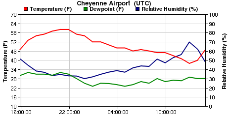
Note the clouds developing into southeast Wyoming in the 0500-0745 UTC time range, similar to what was forecast by the WRF-ARW model. This caused locations under the cloud cover to not cool off as quickly, for example, look at the temperature trace (red line) for Cheyenne, WY:

Temperatures at Cheyenne cooled off gradually to about 1000 UTC, then the cloud cover dissipated allowing temperatures to cool more rapidly to an overnight low of 36 F.
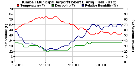
Similarly, at locations further east in the southern Nebraska panhandle, cloud cover kept Kimball, NE from cooling off too rapidly for an overnight low of 42:

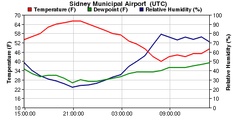
And an overnight low of 40 at Sidney, NE:

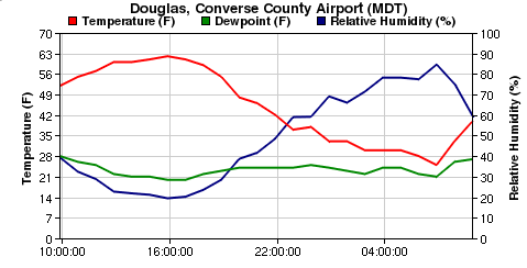
Meanwhile, at Douglas (about 150 miles north of Cheyenne) in east central Wyoming:

Temperatures cooled off more rapidly as skies remained clear, and the overnight low was 25 F.
Real-time synthetic imagery from the 4-km NSSL WRF-ARW model may be viewed here:
Contributor: Becca Mazur, NWS forecast office, Cheyenne, WY
