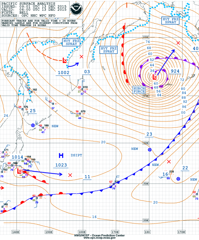
At 0600 UTC 13 December 2015, the NOAA Ocean Prediction Center analyzed a 924 mb surface low in the north Pacific in the vicinity of the western Aleutian islands:
The analyzed minimum central pressure of 924 mb ties the record for lowest pressure in the north Pacific during the period of record (since the winter of 1969-1970).
Satellite imagery from the new Japanese satellite (Himawari-8) provided a spectacular perspective of this cyclogenesis event. First, we will look at the larger scale by analyzing the RGB airmass product (please allow sufficient time for this loop to load):
Warmer air is displayed in green and red where the green regions have higher moisture content than the red regions. Mid-latitude air has a bluish color and areas of dark red show areas of subsidence and high ozone and potential vorticity. Click here for more detailed information.
The first feature that catches your attention is typhoon Melor east of the Philippines. As you may suspect for an intensifying tropical cyclone, green colors in the vicinity of the storm indicate higher moisture.
Focusing our attention to the extra-tropical cyclone further north. Early in the loop, we see the system over Japan moving northeast with a trailing deformation zone on the northwest flank of the cyclone. In time, this feature dissipates as we see the system intensify, it develops a comma cloud followed by a strong surge of high ozone air (orange/red colors) associated with the dry slot. This corresponds to a stratospheric intrusion deep into the troposphere. Soon after this feature we see a cusp that develops and eventually wraps cyclonically around the upper low until becoming vertically stacked by the end of the loop. Note the red/orange colors during this process as well, corresponding to high potential vorticity that is tracked by the high ozone air caused by the stratospheric intrusion.
Next we’ll look at the longwave infrared (11 um) loop zoomed in over the north Pacific:
In this channel, we can see low-level cumulus clouds which correspond to low-level cold advection over the relatively warm sea surface. The position of the cold front can readily be tracked by following the low-level cumulus. When the cold front wraps around the low and intersects the warm front, the occlusion process begins. The leading edge of the relatively colder clouds that wrap around the system appear to be associated with a sting jet. Wind gusts over 100 knots were observed with this storm.
Finally, we analyze a zoomed in perspective of Himawari True Color / Geocolor imagery:
Alternately, you may view this loop:
http://rammb.cira.colostate.edu/ramsdis/online/loop.asp?data_folder=loop_of_the_day/20151213000000&number_of_images_to_display=100&loop_speed_ms=100
True color imagery is shown during daylight hours, and Geocolor imagery is shown during nighttime hours. The CIRA Hybrid Atmospherically Corrected (HAC) method is applied to produce this “true color” imagery.
The Hybrid Atmospherically Corrected (HAC) true color method uses the red, green, and blue Himawari bands, in addition to some information from bands 4 (0.86 micrometers) and 13 (10.4 micrometers). A Rayleigh correction is performed at each band in order to correct for the effects of Rayleigh scattering. The result is an image that is significantly more crisp and clear, and less milky, than without the correction.
Once the imagery transitions over to nighttime the CIRA Geocolor algorithm is applied to the imagery. White colors are high level ice clouds, reddish colors represent lower level liquid water cloud and city lights (static) are shown in yellow.
For more detailed information on analyzing spiral rings around extra-tropical cyclones, see this article.
Real-time Himawari-8 imagery may be viewed at:
http://rammb.cira.colostate.edu/ramsdis/online/himawari-8.asp


Comments
One response to “Himawari imagery of 924 mb low in the Pacific”
Excellent analysis of this event. As a supplement, we have GOES-15 and Himawari-8 water vapor imagery of the storm posted on the CIMSS Satellite Blog: http://cimss.ssec.wisc.edu/goes/blog/archives/20209