The GOES-16 data posted on this page are preliminary, non-operational data and are undergoing testing. Users bear all responsibility for inspecting the data prior to use and for the manner in which the data are utilized.
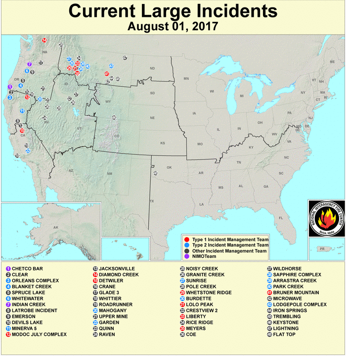
Fires have been burning for some time in Montana as well as western Canada, as seen in the latest large fire incident map for 1 August 2017 below.
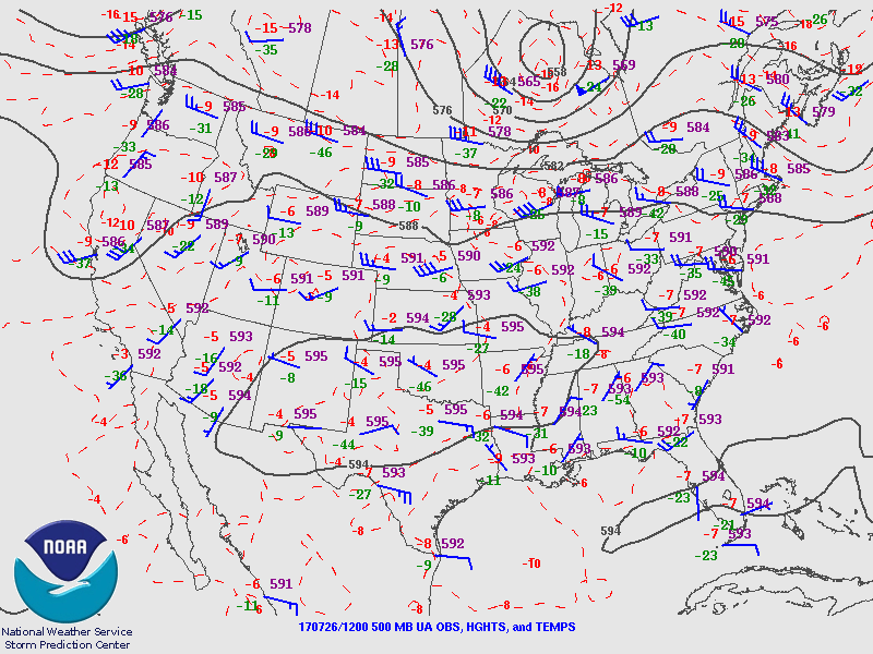
A broad upper-level ridge over the southwest to south-central CONUS has generally kept the smoke on an eastward trajectory.
500 mb plot and analysis from 1200 UTC on 26 July 2017.
A significant change to the pattern is occurring this week with a retrogression of the upper level ridge towards the West Coast (coincident with the very hot weather across the Pacific NW), allowing for shortwave troughs moving out of Canada to deepen into the central and eastern CONUS. This has changed the flow across the High Plains southward through the eastern Rockies from west-southwest to north/northeast, as seen in the 500 mb analysis from this morning (1200 UTC/1 August, below).
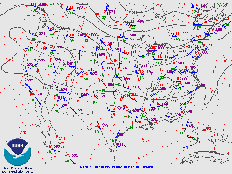 500 mb plot and analysis from 1200 UTC on 1 August 2017.
Smoke from fires can be a health hazard and if thick enough may negatively influence the development of convection, so tracking and monitoring the smoke is a concern for forecasters. In the pre-GOES-16 era we know that smoke is typically most apparent on visible imagery near sunrise or sunset (as well as for an observer on the ground). There are many bands and products available now with GOES-16, and here we take a look at a few of these from early (1317 UTC on 1 August) this morning to see the differences in the appearance of smoke.
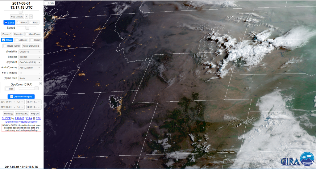
First we look at a type of imagery developed at CIRA known as GeoColor. Using a layering technique it combines 0.64 µm (Band 2) visible imagery with a “True Color” background during the daytime, and 10.35 µm (Band 10) IR imagery (along with 10.35-3.9 µm imagery to highlight fog and low clouds) with a static image of nighttime lights during the night. This allows for a seamless transition from day to night when viewing a loop of the imagery. Unique to GeoColor is the True Color background, which without a special algorithm developed using Himawari imagery would not be possible, since GOES-16 does not have a green band. GeoColor creates a synthetic green band and by using this is able to make a very realistic looking image of the daytime surface, similar to what one would see if on the International Space Station. GeoColor is available for display in AWIPS-2 through the LDM, currently at a reduced temporal resolution of 15 minutes. If interested in the product send an email to myself (Edward.J.Szoke@noaa.gov) or Dan Lindsey (Dan.Lindsey@noaa.gov). Dan presented a recent FDTD GOES-16 Applications Webinar (also known as a VISIT Satellite Chat) on GeoColor and some of its applications (the powerpoint can be downloaded and a recording viewed at http://rammb2.cira.colostate.edu/training/visit/satellite_chat/ ). You can also view real-time GeoColor imagery, as well as all the GOES-16 bands and some RGBs, online at http://rammb-slider.cira.colostate.edu/ ). The GeoColor image from earlier today at 1317 UTC (1 August) is shown below.
GOES-16 GeoColor image at 1317 UTC on 1 August 2017.
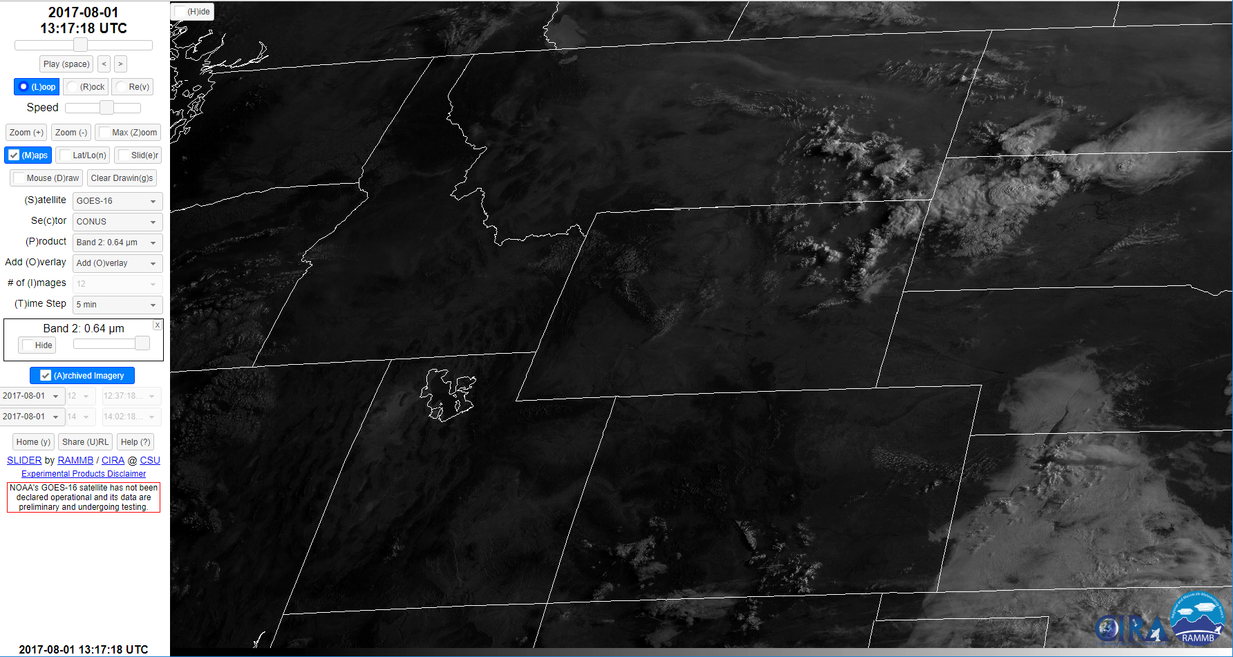
We see both the nighttime and daytime version of the GeoColor imagery in the image at 1317 UTC, with nightlights visible for some of the cities from Utah and Arizona westward. In the daytime portion of the imagery the smoke is nicely seen extending from northeastern Colorado northwards to Montana and then east across the Northern Plains. Now let’s contrast this image with the traditional visible imagery (Band 2, and 0.64 µm) from GOES-16 for the same time.
GOES-16 Band 2 (visible 0.64 µm) image at 1317 UTC on 1 August 2017.
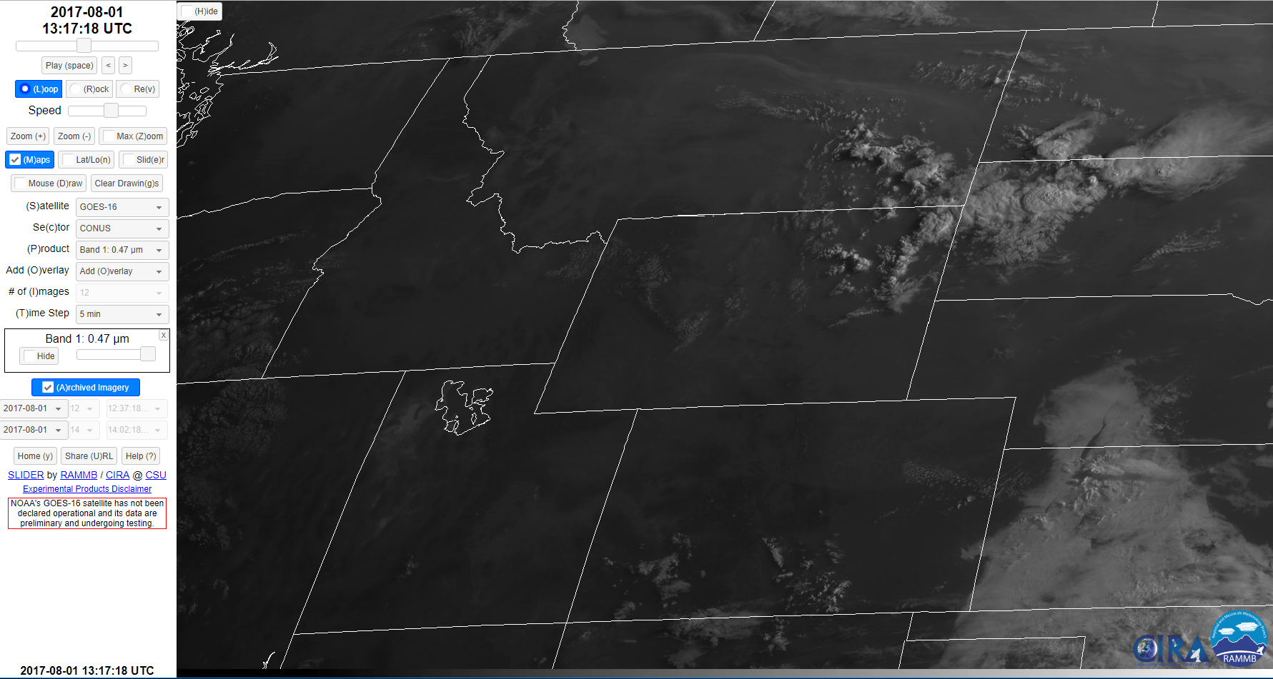
Some of the thicker smoke is visible across the northern portion of the image from Montana to North Dakota, but most of the smoke is not easily seen. Smoke can typically be seen better in the visible imagery at 0.47 µm (Band 1 on GOES-16) because it has higher reflectance in the presence of atmospheric aerosols compared to Band 2.
GOES-16 Band 1 (visible 0.47 µm) image at 1317 UTC on 1 August 2017.
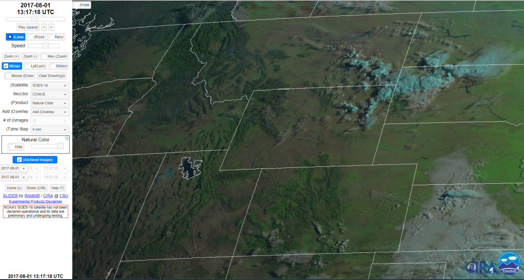
For this case we do not see much difference between Band 2 and for both images the extent of the smoke is hard to determine compared to the GeoColor image. An RGB image developed by CIMSS known as Natural Color (available in AWIPS-2) attempts to replicate True Color without using the complexities involved in the GeoColor imagery. As seen in the Natural Color image below, while the background colors show many features of terrain and vegetation, they are not as “true” a representation as one gets with GeoColor. However, often the colors of the background image make it easier to discern smoke and dust when compared to the visible imagery bands 1 and 2.
GOES-16 Natural Color RGB image at 1317 UTC on 1 August 2017.
For this case some of the smoke is easier to see across the northern portion of the image, but again we do not have the extent of smoke (especially thinner smoke layers) that were seen in the GeoColor image.
An interesting forecast product that is being run experimentally at NOAA/ESRL/GSD is a version of the HRRR with a chemistry formulation that is initialized for fires at this time using information from VIIRS. The HRRR-Smoke model is run in non-operational mode four times per day out to 36-h and output can be found at https://rapidrefresh.noaa.gov/hrrr/HRRRsmoke/ . A forecast from the 00z/1 August run valid at 13 UTC is shown next.
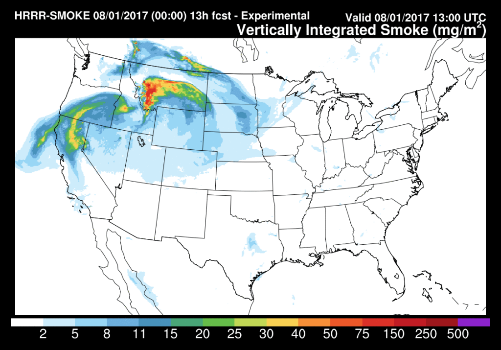 HRRR-smoke 13-h forecast of vertically integrated smoke valid at 13 UTC on 1 August.
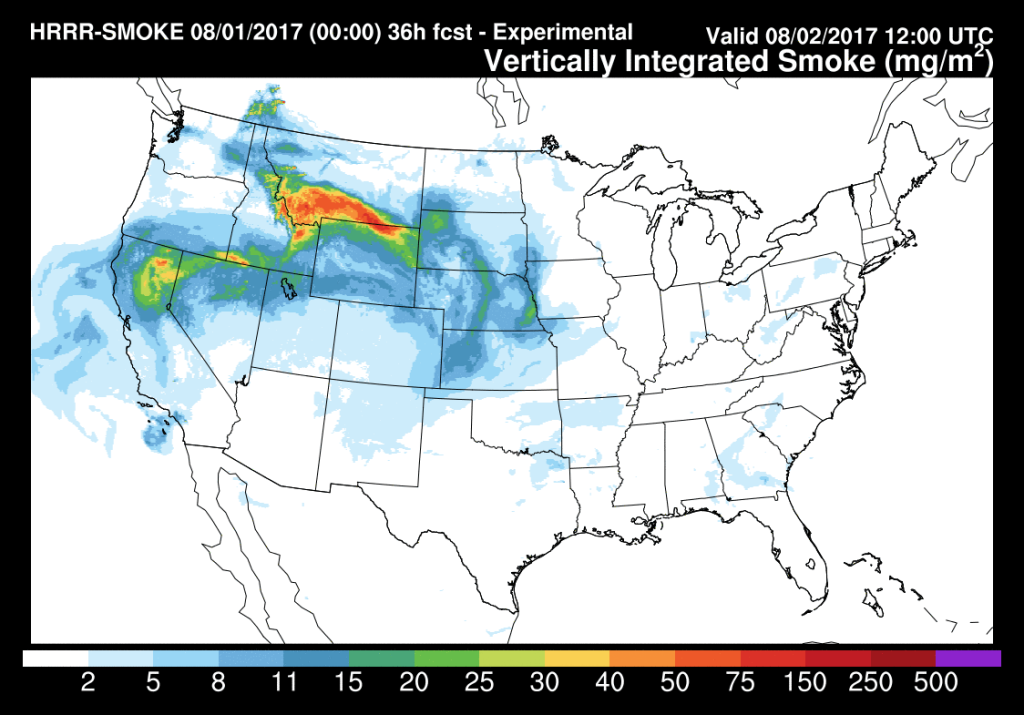
The southern extent of the thinner smoke layer across eastern Colorado in the forecast is in good agreement with the GeoColor imagery shown earlier. The forecast from the same run out to 36-h, shown below, indicates the smoke is expected to continue moving southward into the Central and Southern Plains.
HRRR-smoke 36-h forecast of vertically integrated smoke valid at 12 UTC on 2 August.
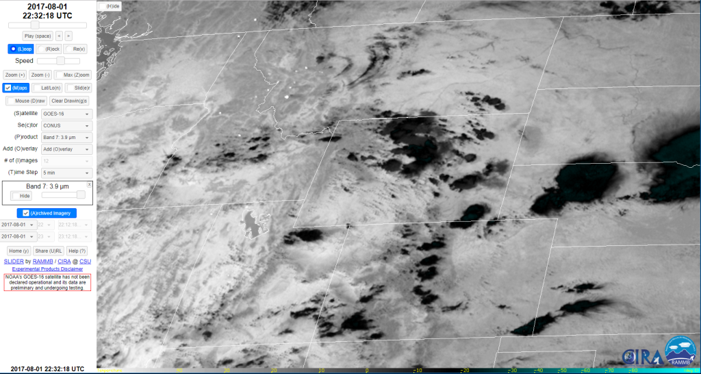
Finally, a look at the extent of the fires using imagery that highlights the fire hot spots. First a look at the traditional 3.9 µm (Band 7) imagery from GOES-16, which of course has greater resolution (2 km) and can resolve higher temperatures than imagery from the previous GOES. An image from this afternoon is shown next.
GOES-16 Band 7 (3.9 µm) image at 2232 UTC on 1 August 2017.
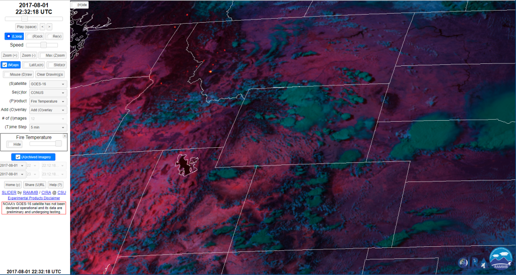
A simple grey color table is used in this imagery, so all fires appear as white dots, which can be seen at numerous spots from central Idaho through western Montana, with another fire in far northeastern Washington and another across the Canadian border. Other color tables are available that discriminate some of the temperatures that can be seen with the GOES-16 39 micron imagery. See, for example, the images posted by Bill Line in his blog on the Southern Plains fires on 6 March 2017 at https://satelliteliaisonblog.com/2017/03/06/meso-sectors-shift-west-for-fire-severe-weather/ Also within that blog Bill shows how fire hot spots can also appear in the near-IR 2.25 and 1.61 µm bands (Bands 5 and 6). CIRA has developed a Fire Temperature RGB that combines information from the three shortwave IR bands (ABI Bands 5, 6 and 7) to provide information on fire intensity. In this RGB composite, the red component is Band 7 (3.9 µm), the green component is Band 6 (2.25 µm) and the blue component is Band 5 (1.6 µm). As a general rule, the more intense a fire is burning, the more radiation it emits at shorter wavelengths. Band 7 is capable of detecting most fires. Less intense fires will only be detected in Band 7 and appear bright red. Moderately intense fires will be detected by both Band 7 and Band 6 and appear orange to yellow, depending on intensity. The most intense fires will be detected by all three bands and appear white. Note that the range detected by this RGB will exceed the temperature range from the Band 7/3.9 µm imagery. The Fire Temperature RGB image for the same time this afternoon is shown next.
GOES-16 Fire Temperature RGB image at 2232 UTC on 1 August 2017.
The same fires are seen in this imagery at various colors, indicating the varying intensities of these fires. The Fire Temperature RGB should be available on your AWIPS-2.
SMOKE UPDATE!
The smoke from the Canadian and Montana (and other) fires also moved into the Pacific Northwest. The link below is to a GeoColor loop over the Pacific Northwest that covers 1-2 August.

