
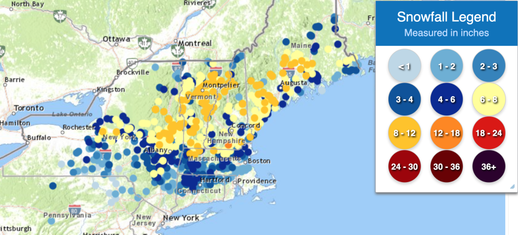
This has not been a particularly snowy winter in New England and the Northeast, with a number of rain events during the season. So naturally, now that “winter” is officially over a snowstorm hit much of the area on Monday 23 March. Here are the snow totals as of Tuesday morning (24 March):
In this blog we will take a look at the different ways to view snow cover using satellite imagery during daytime hours, using a variety of satellite imagery and RGBs that are available for 1400 UTC on Tuesday 24 March.
Satellite imagery can be useful to see snow on the ground using visible imagery (Band 2 on GOES-16), but it can be hard to distinguish snow from clouds, as seen in the image below.
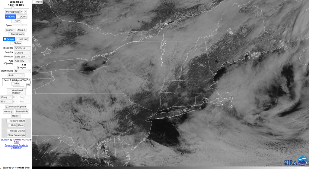
GOES-16 Band 2 Visible 0.64 µm image at 1401 UTC.
As noted earlier, one issue that often arises with using visible imagery to find snow cover is that it looks similar to clouds. The above image points out a different issue in areas where there are lots of trees, in these areas snow cover does not stand out as well as it does, say, in the Great Plains.
With GOES-16 there are several other ways to detect snow on the ground during daytime hours. One possibility is to use other visible bands, such as Band 5, the “snow/ice” band, shown below for the same time (1400 UTC).
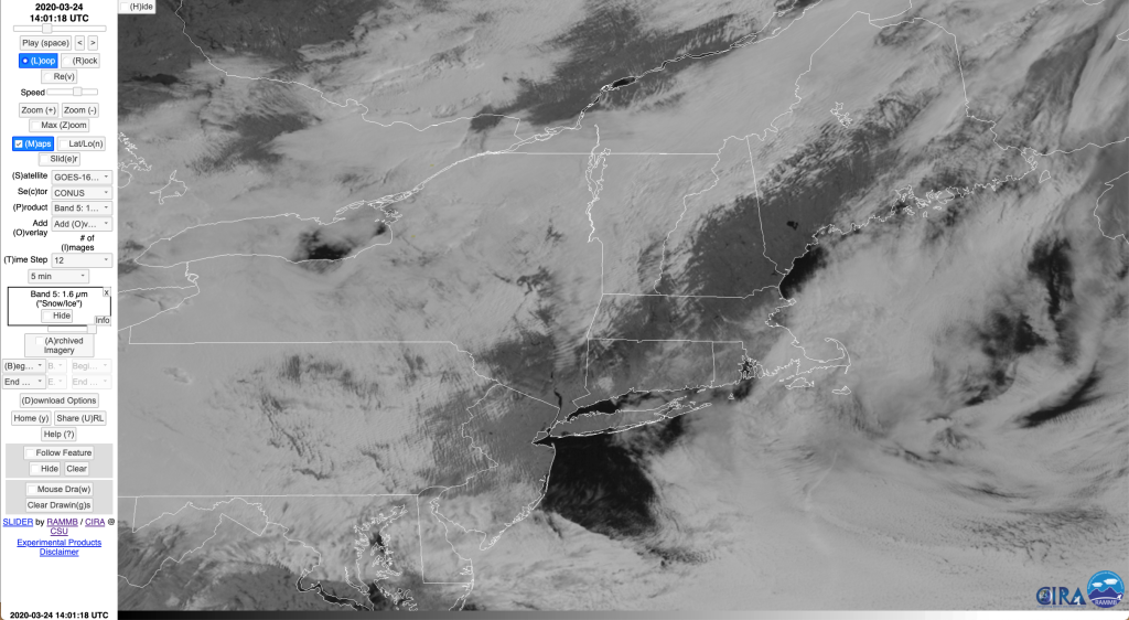
GOES-16 Band 5 Snow/Ice 1.61 µm image at 1401 UTC.
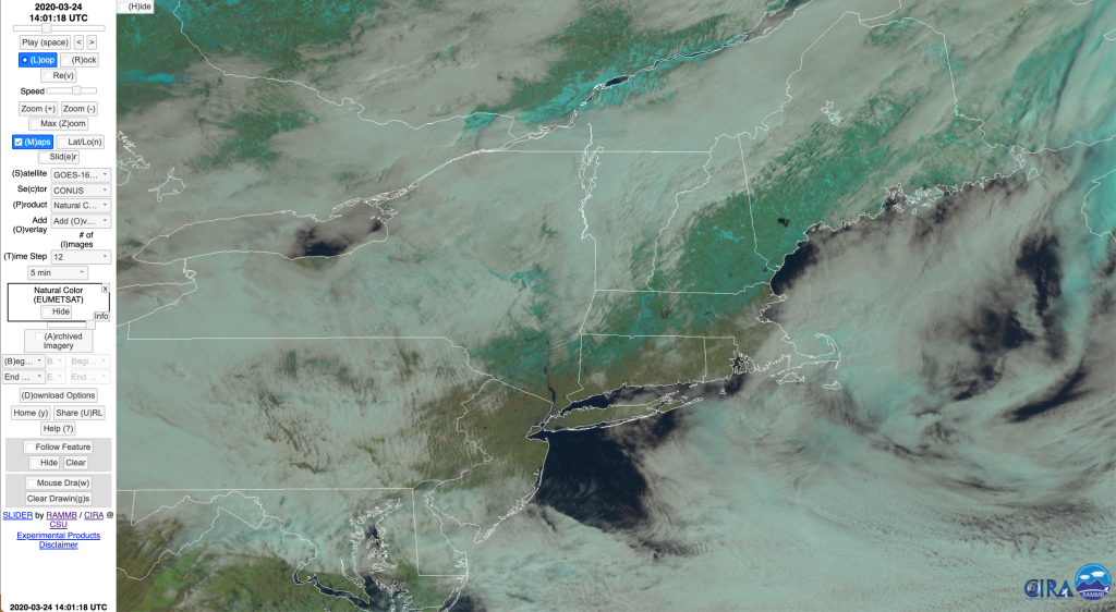
Snow covered ground appears darker than bare ground, and one could argue that this band does make it a little easier to see the snow cover than band 2. There are a variety of RGBs that help see snow, with two of them in fact designed to highlight snow on the ground. Before we look at these RGBs we will check out a couple of RGBs that show the earth in color to see if that helps. One of these is the RGB known as “Natural Color”, shown below for the same time.
GOES-16 Natural Color RGB image at 1401 UTC.
As the name implies, the Natural Color RGB (a baseline product that is available on AWIPS) attempts to show a view of the earth that one might see from space. It is limited somewhat in that GOES-16 does not have the Green Channel, so the colors in this imagery are not as good as they could be from satellites that have all 3 color channels (red, blue and green), such as the Himawari satellites. An interesting RGB that was developed at CIRA and is now widely available across the NWS (not on the SBN yet, as it is not a baseline product at this time) called GeoColor provides a closer representation of what a viewer would see from space (with additional corrections that reduce detrimental viewing effects and render the image clearer). It does so by using a “synthetic” green channel that was derived by training the algorithm on Himawari imagery that does have the green channel. An image for this case, also at 1400 UTC, is shown here:
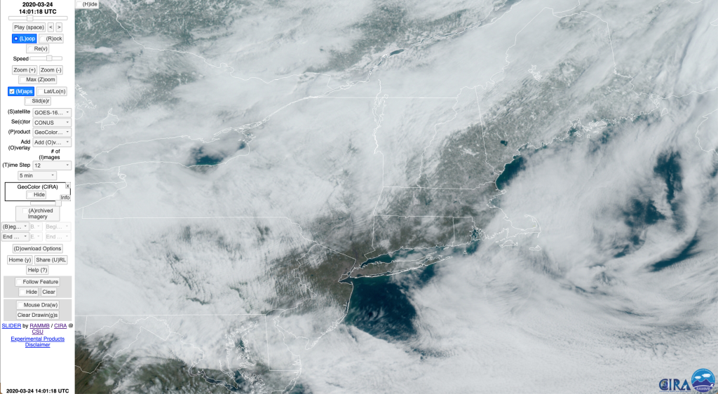
GOES-16 CIRA GeoColor image at 1401 UTC.
Of the imagery shown so far, this RGB makes the snow cover easiest to see. More information on this imagery can be found in this Quick Guide. CIRA can provide instructions for getting it into AWIPS if you do not already have this product.
However, we still have the issue of distinguishing snow cover from clouds (again, not as big an issue for this case given the more splotchy appearance of the snow cover as a result of all the trees). One RGB that is on AWIPS currently does highlight snow (and other features) during the daytime, known as the Day Snow/Fog RGB from EUMETSAT and NASA SPoRT, shown below.
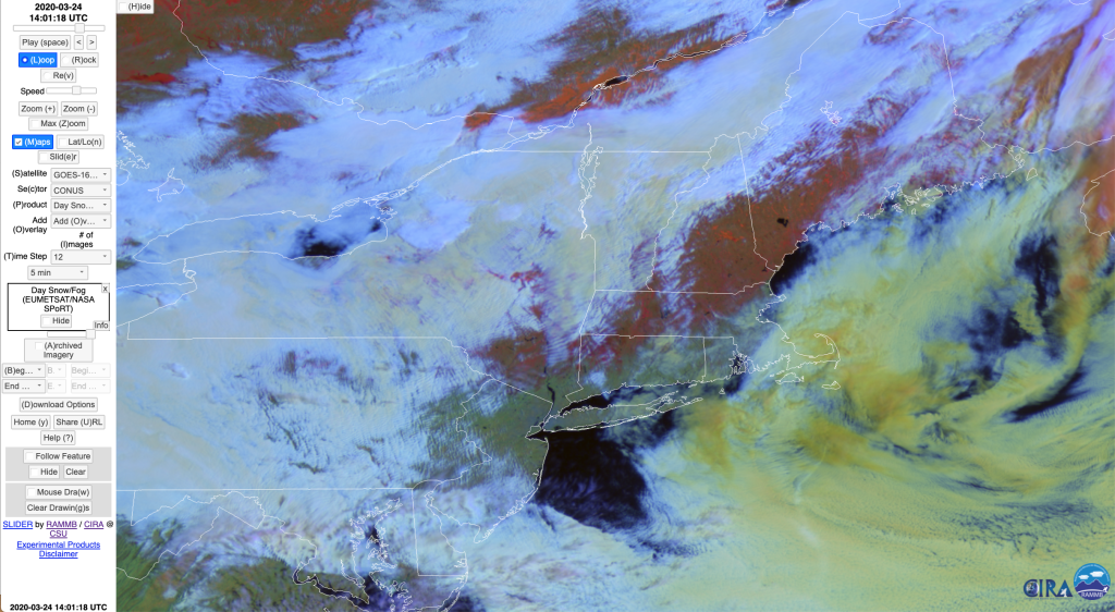
GOES-16 EUMETSAT/SPoRT Day Snow/Fog RGB image at 1401 UTC.
This RGB distinguishes a number of features, as discussed in this Quick Guide. Snow appears as a red-orange color. The variety of colors used can be an issue for some folks, particularly those with some color blindness (like me/Ed!). Another RGB that is an AWIPS baseline product that is also useful in distinguishing snow cover from other features is the Day Cloud Phase Distinction RGB, shown below at 1400 UTC.
GOES-16 Day Cloud Phase Distinction RGB image at 1401 UTC.
As the name implies, a primary use of this RGB is to highlight the difference between water-based and ice clouds. This can be very useful for monitoring growing convective clouds to determine when they begin to glaciate, a necessary precursor to the production of lightning. This RGB can also distinguish snow cover from clouds and bare ground, with snow appearing as shades of green. Unfortunately, other features have shades of green and yellow (as described in the product’s Quick Guide), so some users will have issues separating these colors to find just the snow cover.
Our final RGB to consider is an experimental RGB developed by CIRA that only seeks to distinguish snow cover from clouds and ground (so simpler in what it is trying to do than the above two RGBs), with snow cover shown as white. It is called the Day Snow/Cloud and Day/Snow Cloud Layer RGB (described here). The basic Day Snow/Cloud RGB shows snow cover as white and clouds as yellow/green:
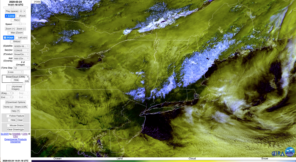
GOES-16 CIRA Snow/Cloud RGB image at 1401 UTC.
Now we can easily see the snow cover in the Northeast, a good portion of which is at this time (1400 UTC) obscured by clouds. The slightly more complicated version of this RGB goes one step further to delineate ice clouds (appearing as magenta) from lower, water clouds (greenish/yellow).
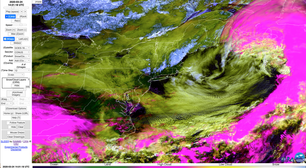
GOES-16 CIRA Snow/Cloud Layer RGB image at 1401 UTC.
We expanded the domain of this image since higher clouds were not present in the more zoomed in view. This RGB is available from CIRA to be ingested into AWIPS via the LDM and is in use at several WFOs; let us know if you would like to try it.
Please send us any comments on this and any of our other blogs. Note that all the imagery shown here was downloaded from the CIRA Slider Tool, available at https://rammb-slider.cira.colostate.edu/ which displays real-time imagery for all the channels from several satellites as well as operational and experimental RGBs, as well as having an archive of data.