by Ed Szoke and Dan Bikos
Total lightning (in-cloud and cloud-to-ground lightning) is available to forecasters from the Global Lightning Mapper (GLM) onboard GOES-16 and GOES-17. Unlike cloud-to-ground lightning, the amount of in-cloud lightning is related to updraft strength, and various studies have seeked to relate in-cloud lightning to the potential for severe storms including tornadoes. The relationship to supercell tornadoes is not clear, owing to the complexities involved in supercell tornadogenesis. But non-supercell tornadoes have been shown to be closely related to updraft strength, implying that total lightning as measured by the GLM may have a possibility of helping with the issuing of warnings for these difficult to identify (with conventional radar signals) and predict tornadoes. A VISIT module was developed in 2015 that explores this connection with a couple of cases (see this VISIT session; note that we are in the process of updating this session with additional cases, stay tuned). In this blog entry we will look at a couple of the tornadoes that occurred in Iowa on the afternoon of 29 May 2019 to see what GLM total lightning showed. The Des Moines WFO has a nice summary of the event here. We will be looking at tornadoes 2 and 3 in their summary.
It was certainly an interesting day in Iowa; the threat for “conventional” tornadoes and severe storms appeared to have moved east ahead of an unusually strong (for late May) upper level low moving northeastward out of the Rockies, which by late afternoon was centered over northwestern Iowa.

Fig. 1. 500 mb analysis valid at 22z/29 May from the SPC Mesoanalysis page.
Often the colder air aloft present with the core of an upper level low can provide the setup for shallow but intense convection that can produce severe weather or even tornadoes (either of the non-supercell variety or from “low-topped” supercells). Indeed, forecasters at the Des Moines WFO recognized this possibility in the AFD issued at 3:39 AM CDT on 29 May: “While the instability will be limited and flow fields are not nearly as strong as yesterday, the proximity of the aforementioned surface low and its effects on low-level shear and convergence fields are suggestive of a conditional severe weather threat with any storms that do develop. This would be in the form of pulsey/isolated wind/hail, but also the threat of an isolated tornado cannot be ruled out in such an environment.”
And the Day 1 Hazardous Weather Outlook issued that morning stated:
“Scattered thunderstorms are possible this afternoon and evening. Isolated severe storms may occur with quarter sized hail, 60 mph winds and a funnel cloud or landspout tornado possible.”
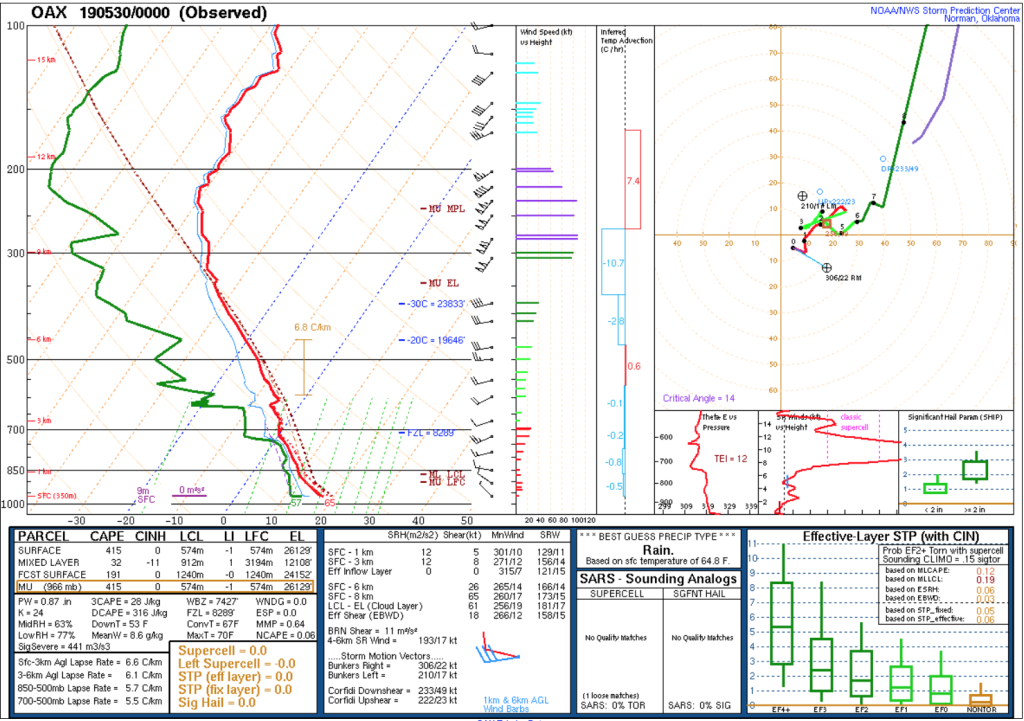
An upstream sounding from Omaha (OAX) at 00z/30 May shows the instability present in the lower parts of the troposphere.
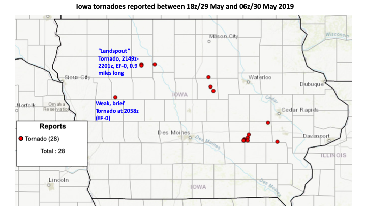
 Enough vertical wind shear exists to consider the possibility that some of the storms may have grown to be shallow supercells, so here we will only consider the first couple of tornadoes of those that occurred (the two labelled in the figure below), shown in this plot from SPC that covers the entire period (the summary issued by the Des Moines WFO counted 8 total tornadoes).
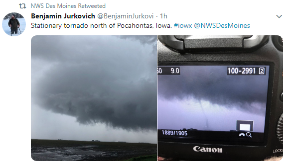
 Below are a couple of pictures of the more northern of the two labeled tornadoes taken from the Des Moines WFO Twitter page, tornado #2 from the WFO summary, labeled the “Pocahontas tornado”.

In the “old days” these funnel clouds were often referred to as “cold air funnels”, owing to their occurrence in a colder environment (with cold air aloft) not typical of tornado development. But we know that in fact they can touch down (as they did in Iowa) and are legitimate tornadoes. (Somewhere I saved a headline from the Madison, Wisconsin newspaper about a similar event, I think over 20 years ago, with the interesting headline “Cold air funnel hits car dealership”. I guess that would be a tornado! If I find it I’ll add to this post.)
So what did the GLM show for total lightning with these two tornadoes. To answer this question we will look at a loop of a 4-panel from AWIPS with 3 types of GLM output in three of the panels (Flash Extent Density in the upper left, Average Flash Area in the upper right, and Total Optical Energy in the lower left, so far only Flash Extent Density has been correlated with non-supercell tornadoes) and the Day Cloud Phase Distinction RGB in the lower right (a Quick Guide on this product can be found here). The circle represents the area covered by the AWIPS Meteogram Tracking tool, output from which we will show shortly.
The first tornado, the more southern of the two (labeled tornado #3 in the WFO summary, was the first tornado of the afternoon in Iowa and is a brief tornado that occurred at 2058z. If you stop the loop at the very first image it is a minute after this tornado was observed. It turns out that no lightning was observed with the parent cell, suggesting a very shallow storm perhaps not even (or barely) reaching the freezing level, since mixed precipitation (ice and water) is necessary for lightning to form. Assuming the location of this tornado is correct, it occurred in the very southwest corner of the county and to the southwest of the county where the center of the meteogram tracking tool is located. In agreement with no lightning being observed, this would be in the shallow cells located to the south of the more developed short line that did have glaciated clouds (more green and yellow colors) seen in the RGB image at 2059z. So for this tornado the GLM did not provide any help.
For the second tornado (tornado #2 in the WFO summary) there is lightning that is observed by the GLM. The tornado was observed beginning at 2149z and ending at 2101z within the circle on the 4-panel. Concentrating on the Flash Extent Density in the upper left panel, we can see a sharp increase at 2141z (stepping through the imagery will probably be necessary to pinpoint this), then a decrease up to the tornado time (note we are looking at 1-minute GLM products here, updated every minute). If we look at the output from the Meteogram Tracking Tool in the image below, we can quickly get a more quantitative view of the lightning behaviour with time.
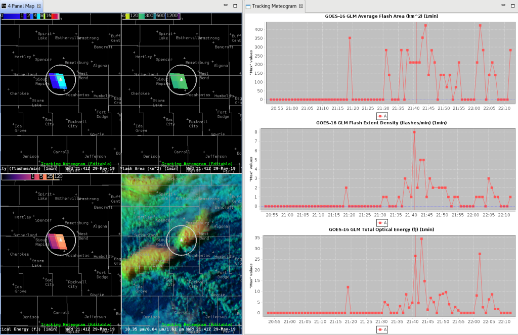 The Flash Extent Density graph is in the middle panel on the right, with the sharp increase seen in the imagery shown on the plot at 2141z, 8 minutes before the tornado was first observed. (We are assuming that the beginning tornado time is accurate. It appears that the tornado was well observed, so this is probably a good assumption). The Day Cloud Phase Distinction RGB also shows a rapidly growing tower that is glaciating for this cell that produced the tornado. The tracking tool can be tricky to use in real time, but for this case (and probably a lot of non-supercell tornado cases since they often occur with fairly low winds aloft) the storm did not move much so the radius selected captured the entire storm without worrying about storm motion. While the Flash Extent Density increase was apparent in the image display in the upper left panel, it might stand out even more on the tracking tool plot.
So how might one use this in a warning situation? Certainly the GLM is only one piece of information to accompany other input. Radar reflectivity and velocity might be good choices for a couple of the panels (although often the circulations with these types of tornadoes can only be seen if the storm is close to the radar), with the RGB shown above and the Flash Extent Density product in the other 2 panels of a 4-panel display. For this case, here is another 4-panel with Composite Reflectivity in the upper left panel, Flash Extent Density in the upper right panel, but this time instead of displaying this GLM product in 1-minute intervals we have chosen a 5-min interval that is updated every minute, to see if this might make a mini “lightning jump” more apparent. In the lower left is the Earth Networks lightning display, and in the lower right the MESH low-level rotation tracks. Stepping through the composite reflectivity loop you may notice an increase in the composite reflectivity beginning at 2144z (it updates at 2-min intervals), which makes some sense if the GLM Flash Extent Density increase that we saw at 2141z represented an increase in the updraft strength, subsequently leading to a stronger storm. The lightning increase we saw in the 1-min interval display in the earlier loop is not as noticable in this 5-min interval loop, suggesting the 1-min long interval updating every 1-min might be a better choice for this application. The very minimal level of rotation noted in the track (lower right panel) implies there was probably not much of a rotational signal with this tornado or parent storm.
Our final loop is of GOES-16 visible (band 2, 0.64 microns) imagery at 5-min intervals (meso sectors were in other locations on this day) with an overlay of METARs. Unfortunately the times are rather tiny owing to an issue with our AWIPS display, but the loop runs from 1821 to 2221z, so the storm of interest develops in the last quarter of the loop and we can see the rapid development during that period. The observations indicate the cell developed within an area of converging flow between the southeast winds to the south and more northeasterly winds to the north. Non-supercell tornadoes typically do form along some type of boundary, with studies often showing an incipient circulation (or circulations) forming along the convergence zone. Such a low-level circulation can then be stretched vertically and if the updraft is strong enough a non-supercell tornado may develop (or “landspout” as it is sometimes called, owing to the similarities to waterspout formation). We don’t have the data to know if such a low-level circulation existed in this case, but the idea of monitoring development along a boundary and then using the GLM data to help identify potential cells with more potent updrafts is a way in which this data may aide in predicting non-supercell tornadoes. There is a more substantial convergence zone to the south of our cell running east from what appears to be the center of the surface low. Perhaps showing us the difficulties involved with warning for non-supercell tornadoes, no tornado comes from this area (recall there was a short-lived tornado, Tornado #3 in the Des Moines WFO storm summary, but it appeared to occur to the south of this other line just before 2100z.
