A period of extremely heavy rain and massive higher elevation snow hit California and other portions of the West during mid-December 2010. Here we take a look at the ORI product for a portion of this storm, concentrating on Central and then Southern California. The ORI (for Orographic Rain Index) product is designed to indicate to forecasters where there is short-term (0-3 hours) potential for heavy orographic rain. The product has a horizontal resolution of approximately 1 km.
Three data sources are used to create the ORI product:
- Blended Total Precipitable Water (TPW) from CIRA, which indicates the strength and location of atmospheric rivers impinging on the U.S. West Coast,
- GFS 850 mb winds (V), which are used to advect the water vapor to a forecast time (every 3 hours), and
- USGS Global 30 Arc-Second Elevation Data (GTOPO30) terrain elevations (H) (horizontal resolution of approximately 1 km).
The CIRA TPW product is derived from water vapor measurements from various non-GOES sensors/satellites to determine Total Precipitable Water. In the future GOES-R will provide these measurements, so this is why the ORI product represents an application that will be available in the GOES-R era. More information on the ORI product can be found in the CIRA ORI Product Description, which is available at http://rammb.cira.colostate.edu/research/goes-r/proving_ground/cira_product_list/.
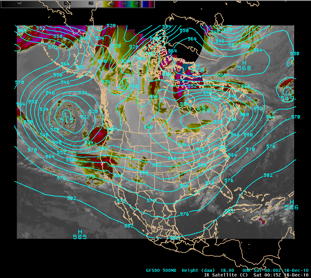
This event was a classic “atmospheric river” type with a long fetch of Pacific moisture aimed at California. An IR image shown below in Figure 1 near the beginning of the event illustrates this extensive moisture plume, with the first wave of the event about to come onshore.
Figure 1. IR image overlaid with a GFS 500 mb analysis at 0000 UTC on 18 Dec 2010.
As noted earlier, the precipitation totals for this event were quite large. The 7-day accumulated precipitation estimate shown in Figure 2 illustrates this, with a large area in the 10 to 20 inch range. Topography played a huge role, as it typically does in such events. Details of the terrain for the scale of some of the images to be shown are shown in Figure 3.
Figure 2. Estimated 7-day total precipitation ending 1200 UTC 20 Dec 2010.
Figure 3. Details of the terrain are shown in these two images. The radar and ORI images shown below are on the scale of the zoomed in image on the right.
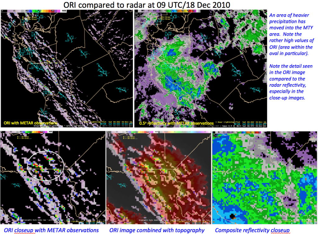
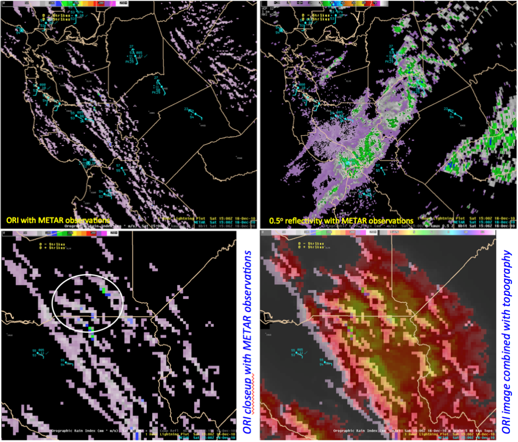
The next few images show a demonstrate the ORI product as the first wave of heavy precipitation moved inland for four different times from 0600 UTC through 1500 UTC. All of the images are taken from an AWIPS display localized for the Monterey WFO. For each time a comparison is made between the ORI product and what the radar reflectivity looked like for an area centered on Central California. The bottom images for each time are zoomed into the area that is depicted on the right side of Figure 3. The ORI image is shown in the lower left panel, with the same ORI field combined with a topography image next to it. For the 0900 UTC time an additional radar image is shown on this same scale.
As forecasters know, radar can have a tough time resolving precipitation in regions of complex topography. The beauty of the ORI product is that it focuses specifically on topography and how it influences the impinging moisture field, as determined by the TPW, and as influenced by the flow driving this moisture into the higher terrain. This is nicely seen in the images below. One of the downsides to the ORI product from the forecaster standpoint is that the ORI value is an index and not a precipitation measurement. Further experience by forecasters with the ORI product will help to determine how the ORI values relate to significant precipitation amounts that will help to improve its usefulness for nowcasting. As discussed in the ORI Product Description, some guidance on ORI values based roughly on the work of Nieman et al. 2008 (J. Hydrometeorology, 9, 22-47) are: 50 kg s-1 m-1 (the units of ORI) are set as a threshold below which no rain is likely, while a value of 250 kg s-1 m-1 which definitely deserves the forecaster’s attention. (Maximum values are probably in the 500 kg s-1 m-1range.) In the example below, ORI increases to a value above 200 in the region highlighted by the white oval by 0900 UTC, then falls off as the heavier precipitation moves further inland.
Figure 4. ORI comparison for 0600 UTC on 18 December. The scale of the two bottom images are the same as the zoomed in image shown in Figure 3.
 Figure 5. ORI comparison for 0900 UTC on 18 December.
Figure 6. ORI comparison for 1200 UTC on 18 December.
Figure 7. ORI comparison for 1500 UTC on 18 December.
Further details on this case will be forthcoming, but it is hoped that additional examples can be added to the blog from cases yet to come as the rainy season (finally) gets under way.


