GOES-14 was operating on super rapid scan operations schedule for May 11, 2014, meaning that images were being taken every 1 minute. This high temporal resolution data will be routinely available for severe weather events with GOES-R, therefore it is beneficial to learn how to maximize the value added by this dataset. SPC issued a moderate risk for portions of Nebraska and Kansas which will be the focus here. The GOES visible imagery from 1838 to 2011 UTC is shown here:
http://ga2.cira.colostate.edu/Lindsey/11may14_g14_vis_loop.gif
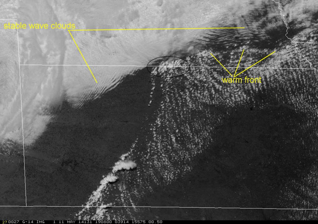
To aid in interpretation of this loop, an annotated image is shown:
Around this time, a southwest-northeast oriented cold front was surging southward in western Kansas while a dryline was positioned just east of this cold front where convective initiation occurs in southwest Kansas. An east-west oriented warm front is annotated above, which was slowly moving northward. Moderate instability and high shear existed along the warm front in southeast Nebraska. The warm sector is characterized by cloud streets, parallel to the low-level (southerly) flow while north of the warm front a much more stable air mass exists characterized by stable wave clouds oriented perpendicular to the winds at inversion top level.
Earlier convective initiation occurs in southwest Kansas along the dryline. The high temporal resolution allows one to see multiple updrafts attempting to penetrate the capping inversion and eventually lead to thunderstorm development. The first sign of convective initiation are shadows projected by anvil cirrus.
Further north, in the region delineated with an oval in the annotated image above, we can see attempts at convective initiation along the western portion of the warm front, near the intersecting cold front. Multiple updrafts merge into one dominant updraft region where the supercell develops. Initial motion of these updrafts is towards the northeast, but by the end of the loop as we see one dominant updraft we can already see indications of this storm turning towards the right (east) along the warm front.
For access to real-time GOES SRSO (when available) click here:

