Our Thoughts and Hearts Go Out to the Boy Scouts of Nebraska and Iowa

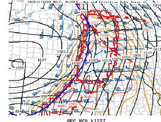
(From SPC MCD 1327 – Concerning Tornado Watch #509)
Jeff Braun
Wednesday night, June 11, 2008, at just after 6:30 PM, some 93 boys, ages 13 to 18, along with 25 adult BSA staff members, were fighting for their lives as a deadly tornado roared through the Little Sioux Boy Scout Camp. Four of the Boy Scouts ended up losing their lives in this fight against Mother Nature while attending what was to be a weeklong leadership training camp. Over 40 others were also injured and were either rescued and/or attended to by other staff and scouts who used their emergency/first aid training to the best of their abilities. You couldn’t ask for a better bunch in a situation like this…and even then there were some terrible results.
The synoptic/mesoscale set-up had a cold front extending from a surface low pressure center over eastern South Dakota, south through eastern Nebraska and into central portions of Kansas. A warm front stretched from the surface low eastward across southern Minnesota (not far north of the Iowa border). In between these two features lay the warm (and moist) sector with surface temperatures ranging from the mid 70s (north) to nearly 90 (south) and dew points in the upper 60s to lower 70s. There was also a slowly moving (westward) mesoscale boundary (through Iowa). Mixed layer CAPE ranged from around 1500 j/kg (north) to nearly 3000 j/kg (south) by this time with lapse rates above 700mb were running between 7 and 8 deg C/km (there was just a bit of a cap present near and above 600mb that kept the lid on long enough to make things explosive). Effective shear was running between 40 (far south) and 60 (north in Minnesota) kts with low level storm relative helicities ranging from 200 (south into Kansas) to nearly 500 m2/s2 (north into southern Minnesota and northern Iowa).
Movement of the cold front was to the east…with storms initiating ahead of the cold front along a (pre-frontal) trough from southeastern South Dakota into northeastern Nebraska by 4 PM LDT…back-building south southwestward into south central Nebraska by 5 PM (southwest Kansas also had storms going up by 5 PM).
Many of these storms became tornadic within in the first hour since initiation – first starting over portions of northwestern Iowa and southwestern Minnesota…then with reports following, down the line, into eastern Nebraska and western Iowa soon after. Kansas then finished off the evening with continued reports up to just after midnight. All told there were at least 53 separate reports of tornadoes (some reports, however, may be of the same storm) covering the four states of Minnesota, Iowa, Nebraska, and Kansas. There were five fatalities total (the four in Iowa and one in Kansas) and many, many more injured.
Please give the kids a second (and third) thought.
