Flash Flood Season in the Rocky Mountain West – Just a Reminder
Jeff Braun
This is just a brief reminder that it is monsoon/(FLASH) flood season here in Colorado and the rest of the Rocky Mountain West and adjacent High Plains. While this region is no stranger to flooding conditions…particularly in the late spring and early summer when combined severe weather threats often aggravate the ongoing snow melt, a secondary, and often much more dire, flood season often accompanies the arrival of the North American Monsoon (see July 15, 2008 blog).

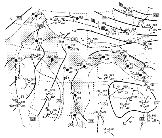
(From: Petersen, W. A., and Coauthors, 1999: Mesoscale and radar observations of the Fort Collins flash flood of 28 July 1997. Bull.Amer. Meteor. Soc., 80, 191–216.) The problem is two-fold, as the increase in subtropical moisture via the monsoon is injected into a rather “quiet” mid-upper level flow pattern (typically associated with a mid-upper level ridge – see 500mb analysis above). If the cap can be broken (which is most often accomplished in the mountains and foothills due to the increase in elevation), the convective storms are most often quite slow to move…sometimes remaining terrain tied to the same area for a period of (several) hours. Even when there is net movement in one direction, it is relatively slow and new development tends to replace the older storms almost immediately…so storm propagation opposite of the storm’s forward motion gives the illusion of remaining in place and going nowhere. This is a most dangerous situation. Flash flooding is always a concern in mountainous terrain anytime of the year where steep valley walls can contain rainwater…forcing it into gullies, creek beds, streams and rivers in a very short period of time. You can be many miles away from the actual storm…not even able to see or hear it…and get yourself in a great amount of trouble in short order. However, this time of year when you add the additional conditions of increased moisture with slow, or nearly “stationary” storm motion – the problem becomes hugely magnified when the rain falls over these same areas. Just a few major flash flooding events of interest that have occurred this time of year “out west” follow:The Big Thompson Flood – July 31, August 1, 1976: During the evening of the 31st, over 4 inches of rain fell across a large portion of the Big Thompson basin in less than 6 hours, with over 12 inches falling in a smaller area containing the western third of the Big Thompson Valley. Much of the canyon was devastated with a 20 foot plus wall of water – killing 139 people! See these links for more information: http://www.coloradoan.com/news/thompson/ , http://www.reporterherald.com/webextra/1976flood/ , and The Big Thompson Fact Sheet .
The Cheyenne Wyoming Flood – August 1, 2 1985: During the afternoon and evening of August 1st, 1985 a nearly “stationary” thunderstorm produced over 6 inches of rainfall in just under 3 hours. Add to this, large quantities of hail (three to four feet deep in some slide areas) and a tornado and you have the makings of a disaster. Twelve people died and over 70 were injured in this mess.
The Fort Collins Colorado Flood – July 28, 1997: The late afternoon and evening of the 27th of July began as a relatively typical thunderstorm event for this time of year with storms blossoming and putting down heavy rain off and on through the overnight hours. It was a little heavier than normal, with a gradient of precipitation from east to west across the city of Fort Collins lying between 0.75 inches and 4 inches…and higher amounts up to nearly 7 inches just to the northwest of town (near Laporte, Colorado). This would only herald the beginning as the next day would be the straw that broke the camel’s back. By noon on the 28th, and under very similar meteorological conditions as the previous day, imbedded thunderstorms once again erupted. In the following six hours anywhere from 1 inch (far eastern Fort Collins) to around 10 inches (far western Fort Collins) of precipitation fell…with rain rates at times as high as 4 to 5 inches per hour. Spring Creek which runs west to east just south of the center of town exploded from its banks, killing five and causing another 200+ million dollars in damage. For more information see the following links: http://ccc.atmos.colostate.edu/~odie/rain.html, http://fcgov.com/oem/historical-flooding.php, http://media.www.collegian.com/media/storage/paper864/news/2007/08/01/News/Video.Fort.Collins.Flood.Of.97-2927035.shtml, http://rammb.cira.colostate.edu/resources/docs/Two_floods.pdf, and http://olympic.atmos.colostate.edu/flood97.html.
The Las Vegas Flood of July 8, 1999: The valley that Las Vegas (“The Meadow”) resides in is a primary reason that rainfall events can get out of hand fairly quickly. Las Vegas is nestled between mountains on nearly all sides…is built over an area that drains these mountains toward the Colorado River…and the composition of the of all this runoff soil/silt is relatively impermeable to water (i.e. runoff). Add to this the thousands of miles of asphalt and cement from all the new building and you have a recipe for disaster. The usual Saving Grace is that the region “normally” only receives about 4 inches of rainfall per year, which if stretched over an entire year is not of concern. However, thunderstorms during the monsoon season can easily put down over a half an inch of precipitation inside of an hour…which is about all that it takes to get flash flooding going in this drain-less oasis in the Mohave.
On this day, rain rates were somewhat higher…bringing between and inch and a half and three inches of rain inside of 90 minutes. There were two fatalities and over 20 million in damages with this “little” storm. Just goes to show how relative conditions are from place to place. Please click here for more info concerning this event.
If you have any interesting season events/phenomena in your region of the world, please let us know and send us the info and images (if you have them)…and we will post them for the interest of others. See “Contact Us” or “Topics, Ideas and Questions” to the right under “Pages.”
