United Airlines Flight 967 – Severe Turbulence, July 20, 2010
Jeff Braun and Dan Lindsey NOAA/RAMMB CIRA/CSU
***(Also, please see addendum near the end of this message)
The following are a sequence of GOES-13 visible images from 19:45 UTC on 20 July 2010 to 00:45 UTC on 21 July 2010.
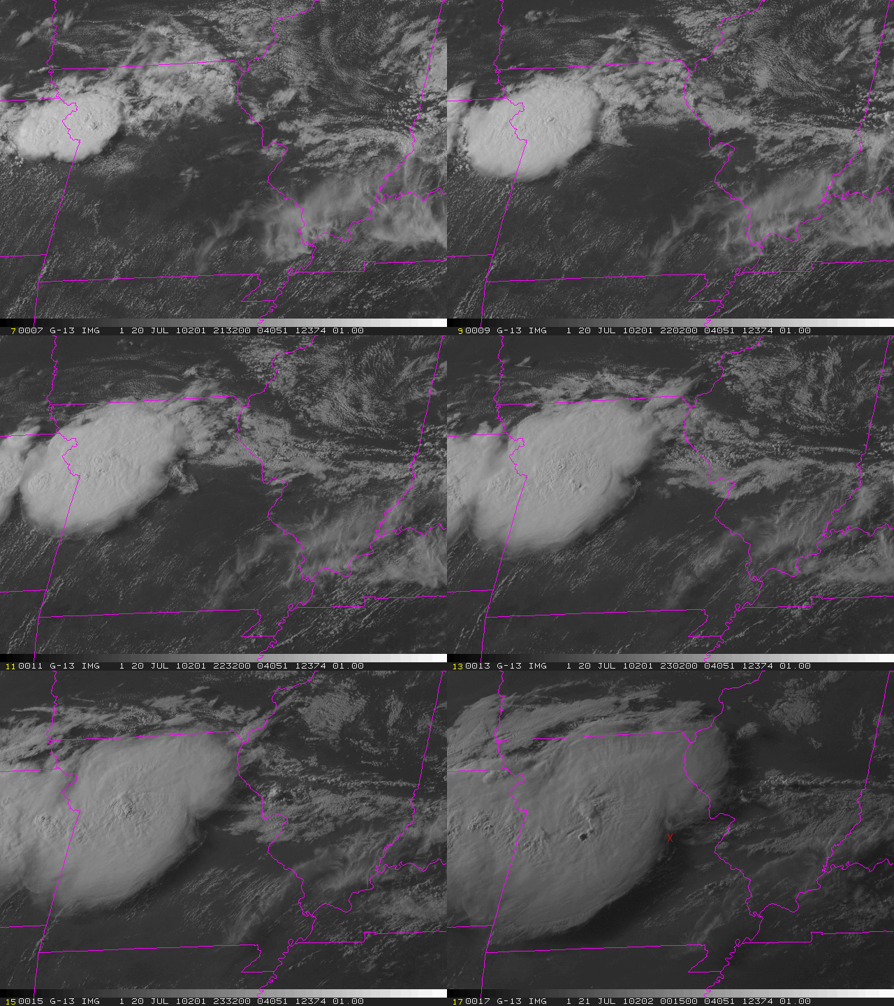
On 20 July 2010, a United Airlines Boeing 777 aircraft experienced severe turbulence during its trip from Washington, D.C., to the west coast. There were multiple injuries reported by the passengers and the plane was rerouted to Denver. Such extreme turbulence is quite rare, so we decided to check and see whether GOES satellite imagery provided any clue as to what caused it.
The loop (above) is GOES-13 visible imagery from 1945 UTC on 20 July to 0045 UTC on 21 July. Convection forms in northeast Kansas by 2030 UTC, and the storms expand in coverage and intensify as they move into northwestern Missouri. The anvil cloud from the convective mass expands so the south and east, and wavelike features are evident atop the cloud. At 2232 UTC, a linear cloud feature can be seen pushing slightly ahead of the expanding anvil in central Missouri. Its height is uncertain, but it appears to be below the ambient anvil, but above the boundary-layer cumulus clouds.
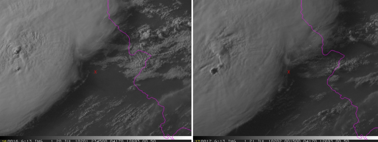
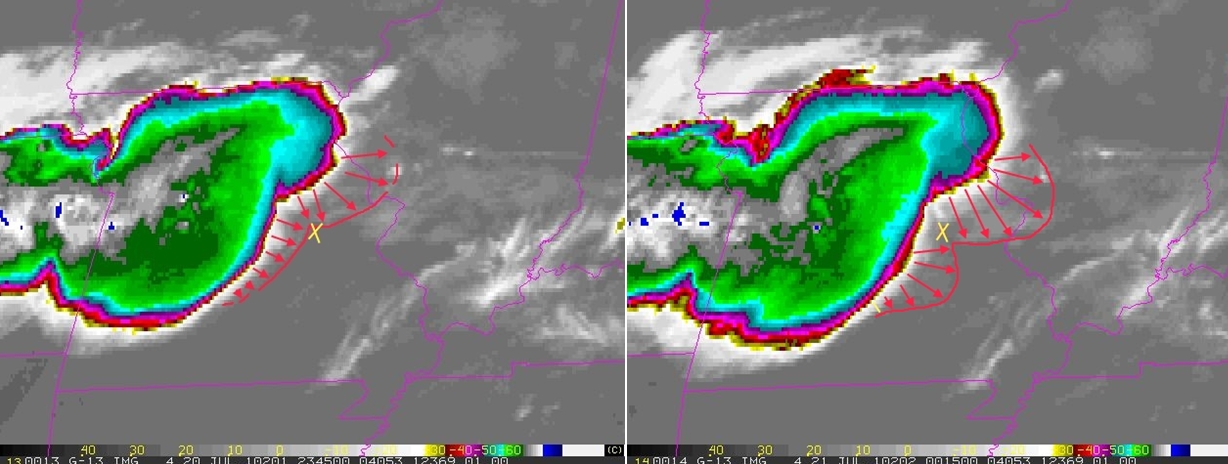
United flight 967 was flying at 38,000 ft. when it reported the severe turbulence at 0001 UTC. The location of the report is plotted on the 2345 and 0015 UTC GOES images by a red ‘X’ (below). Unfortunately, no GOES-East image is available at 0000 UTC because the 2345 UTC image is a full-disk scan. It should be noted that 2345 UTC is the beginning of the 26-minute scan, and since it starts from the north, it was probably scanning Missouri around 2353 UTC, plus or minus a couple of minutes. As can be seen in the loop (above), the above-mentioned linear cloud line appears to intersect the location of the turbulence at the correct time (0001 UTC). However, the anvil cloud is also rapidly moving in that direction.
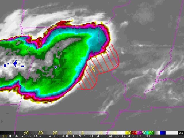
So what caused the turbulence? One possibility is a gravity wave initiated by the convection earlier in northwestern Missouri. However, gravity waves require a stable layer in which to propagate, and a nearby sounding in Springfield showed no such stable layer near 38,000 ft. Another possibility is what can be simply described as an upper-level front generated from the convection. Trier and Sharman (MWR, 2009) discuss how upper-level outflow from an MCS can generate widespread turbulence. They show model-derived perturbation winds at jet cruising altitudes, and significant anomalous winds can propagate away from intense convection. If a plane is experiencing relatively constant head winds (for example), but then suddenly encounters winds from a different direction, it will change the plane’s lift and likely cause it to experience altitude fluctuations while it attempts to adjust to the changed environmental wind vector. So something along these lines might help explain what flight 967 encountered, but this is pure conjecture. Trier and Sharman (2009) also discuss how low values of the Richardson number and elevated regions of Turbulent Kinetic Energy (TKE) can be associated with observed turbulence. If (gravity) waves propagate into an already low Richardson number environment (low stability and or high vertical wind shear), these waves may further reduce the Ri locally to the point of inducing Kelvin-Helmholtz instabilities and turbulence away from the storm. A similar analysis for the present case is needed.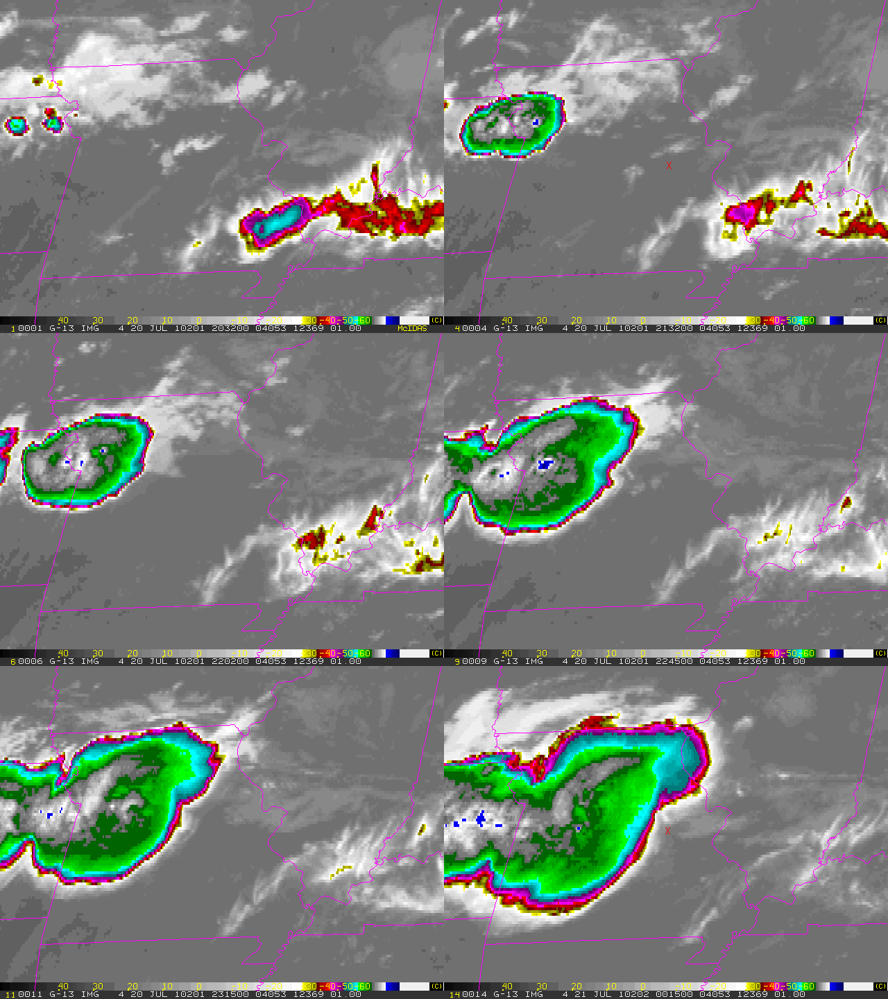 Above is a a GOES longwave IR loop of the same event and time period. Long recognized as a telltale satellite signature for turbulence, these images show the rapid lateral expansion of the cold convective anvil cloud and convectively induce outflow (and very rapid expansion – final 3 frames of loop). Even this sequence of lower resolution geostationary IR window imagery is sufficient to observe this signature as we are simply looking at expansion rates of the anvil cloud pattern and outflow signatures. Rapid anvil expansion indicates strong upper-tropospheric divergence associated with this developing convection. This example shows both signatures, with rapid cloud top expansion followed by very rapid (but on a smaller scale) expansion – represented by a surge of outflow to the east and southeast of the primary convective regions (see below). Strong vertical wind shear between the outflow layer and the atmosphere above/below has induced turbulent mixing which could be responsible for the turbulence observed in this case. In the final two images of the above loop, (images below), the yellow X marks the position of the aircraft and the red arrows and lines mark the “outflow” boundaries (area of most rapid expansion). In the first of the two images (2345Z July 20) the aircraft lies near or just outside the outflow region, however, 30 minutes later (second image – 0015Z July 21)we can plainly see that the aircraft now is well within the outflow surge. The single image (below) with the red hatched area (again, yellow X represents the aircraft position) outlines the most significant turbulent region. This IR image also shows that the brightness temperature of this region falls between the warmer lower levels and colder upper reaches (which could be estimated with the cloud top algorithm). Moreover, this area of extreme divergence represents (locally) a level above and below which there would be maximum negative and positive vertical velocities respectively.
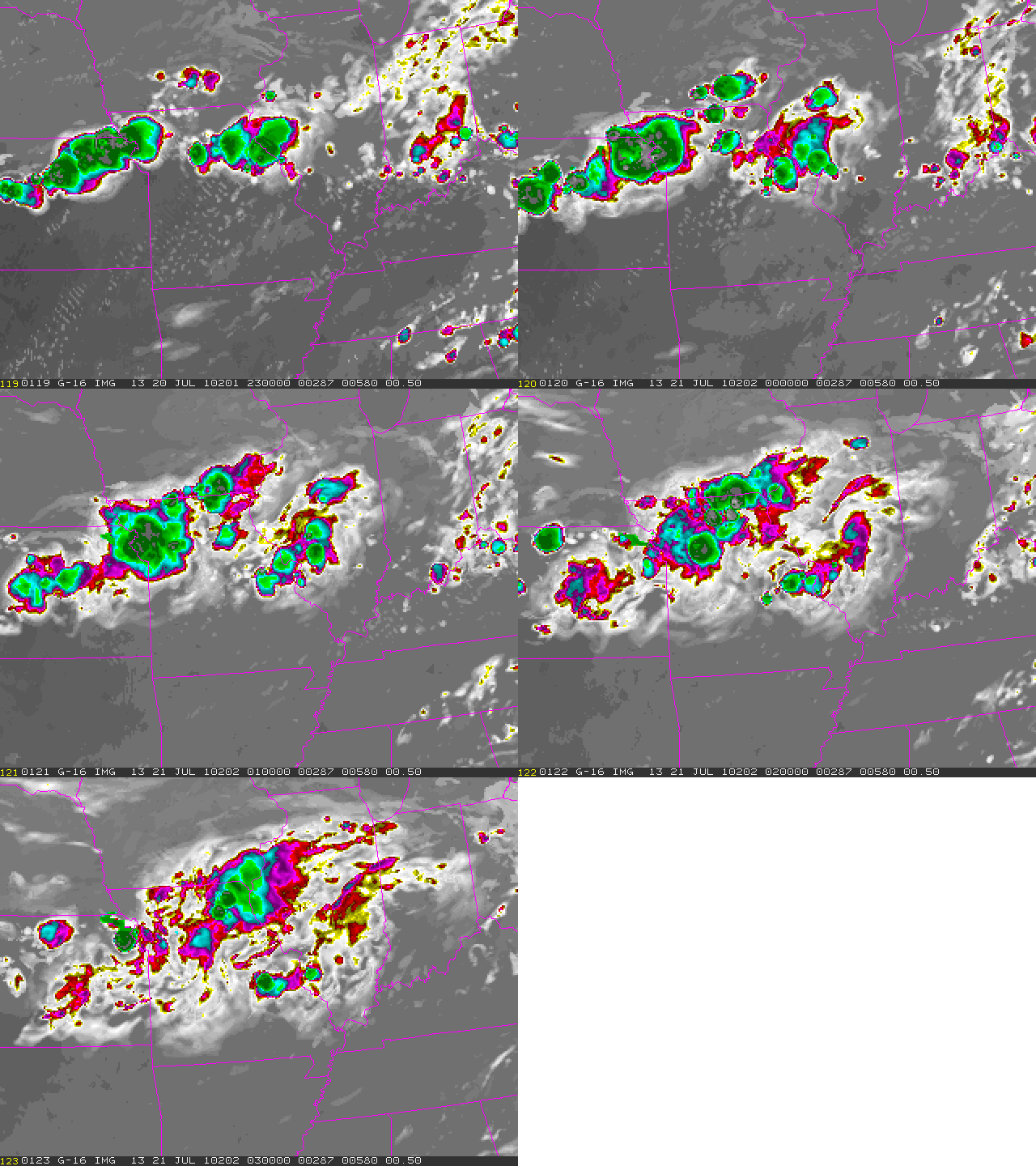
 Finally, we took at a look at simulated satellite imagery from the 4-km NSSL WRF-ARW initialized at 00 UTC on 20 July (below). The series of images show the simulated 10.35 micron data at hourly time steps. Note that the model does a reasonable job of forming the convection in northwestern Kansas, and wavelike features can be seen propagating to the southeast, even though the anvil cloud dissipates too soon in the model. We plan to closely examine the model output to see whether conditions were favorable for turbulence generation (in the model world).
***Addendum***
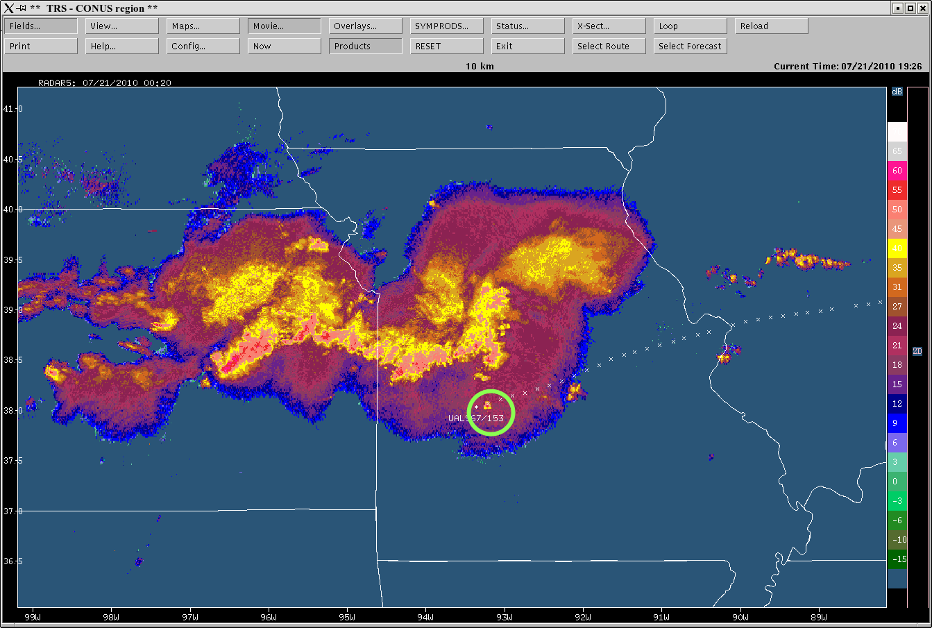
Since this blog was originally posted, new information has been gathered. Thanks to additional data provided by Dr. John Williams (NCAR), it was learned that the location of the aircraft that we were originally given at the time of the event (00:14 UTC) was wrong. The new corrected location is about 100 miles southwest of the old location…well under the southern periphery of the MCS’s canopy. The other piece of information, which undoubtedly added to the turbulence encounter, was the formation/initiation of a convective cell near the path of Flight 967 (see radar image below). While the scenario depicted and explained previously still holds true, with multiple areas of divergence and convergence occurring along with associated strong changes in both horizontal and vertical wind shear, the addition of a growing convective cell near the path of the aircraft would certainly add to the probability of an encounter with severe turbulence.
