Hurricane Matthew 100616
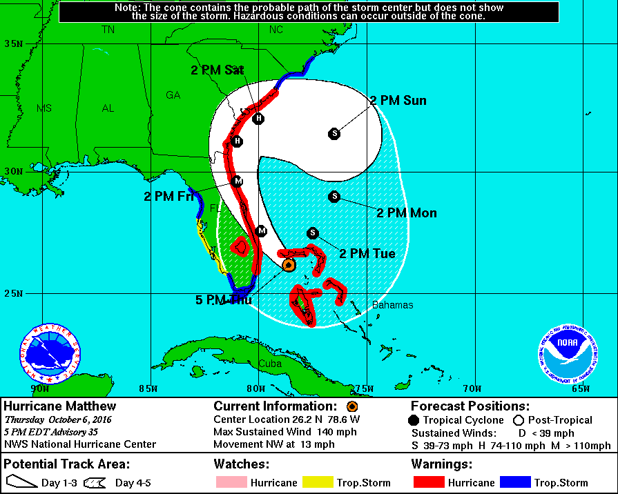
Hurricane Matthew will be making landfall along the Florida coast later this evening, 6 October 2016. Matthew is currently (~5PM EDT) a Category 4 hurricane topping out at winds of 140 miles per hour. Figure 1 below show Matthew’s path headed toward the east coast of Florida, Georgia and the Carolinas producing significant storm surge and flooding along the coast.
 Figure 1: A National Hurricane Center image of the 5-day forecast for Hurricane Matthew. The hurricane is forecast to run along the east coast of Florida, Georgia and the Carolinas. In the image display, the M, H, and S stand for ‘Major Hurricane’, ‘Hurricane’, and ‘Tropical Storm’ respectively.
A current GOES infrared (IR) satellite loop shows the evolution of the hurricane approaching the coastline via the CIRA-RAMMB link here.
The Near-Constant Contrast (NCC) a derived product of the Day/Night Band (DNB) utilizes a sun/moon reflectance model (via AWIPS-II) to track hurricanes during the night-time. Figure 2 shows this morning’s satellite overpass (~0646Z, or 0246 local time) from polar-orbiting data seen below.  Figure 2: An NCC image showing the location of Hurricane Matthew in relation to the state of Florida. One can see the emitted city lights, lightning and the subtle location of Hurricane Matthew’s Eye Wall. In the right hand corner of the image shows the percent visibility of the moon (approximate) and the elevation angle of the moon, -37.54 degrees. This elevation angle value implies that the moon is below the horizon and the atmospheric features displayed in NCC are seen predominately from atmospheric nightglow and by the surrounding emitted light sources.
Emergency evacuations have been declared along the coastline in Florida and Georgia. Stay tuned from more updates over Hurricane Matthew.
