23 March 2017 Convection and Dust in Texas / New Mexico
The GOES-16 data posted on this page are preliminary, non-operational data and are undergoing testing. Users bear all responsibility for inspecting the data prior to use and for the manner in which the data are utilized.
On the afternoon of 23 March 2017, an upper level trough in the western US moving eastward was responsible for a strong lee cyclogenesis event. The mesoscale sector for GOES-16 observed convection along the dryline with blowing dust on either side of it:
The dust is lighter in color. To the east of the dryline, it’s oriented in boundary layer rolls oriented NNW-SSE while west of the dryline where the boundary layer is much deeper in a hot / dry air mass, the dust is much more widespread. What additional details can you see in the convection that you normally would not see with GOES-13/15?
In a GOES-16 4 panel loop showing all 3 water vapor bands in addition to the RGB Air Mass Product:
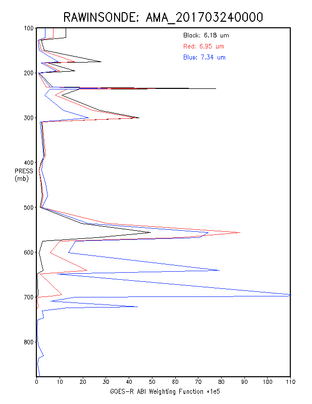
What additional features do you see? Do you see the blowing dust in any of the water vapor bands? Why would the dust be observed in these band(s)? Hint, see the weighting function profile for the 3 GOES-16 water vapor bands, based on the sounding from Amarillo, TX at 0000 UTC 24 March:
Remember that the weighting function profile is valid for clear skies only

