Layer PW product for flooding on 27 July 2017
The GOES-16 data posted on this page are preliminary, non-operational data and are undergoing testing. Users bear all responsibility for inspecting the data prior to use and for the manner in which the data are utilized.
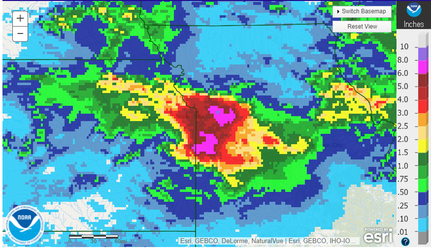
During the overnight hours of 26-27 July 2017, a large area in the vicinity of Kansas City received greater than 5″ of rainfall, with maximum amounts around 8.5″ which led to flooding:
GOES-16 10.35 micron imagery during the overnight hours showed a series of convective clusters moving over the same region (northeast Kansas into west-central Missouri):
The CIRA layer precipitable water (LPW) product depicted the moisture plumes at different levels that contributed to this flash flood event:
Upper left panel Sfc – 850 mb LPW
Upper right panel 850 – 700 mb LPW
Lower left panel 700 – 500 mb LPW
Lower right panel 500 – 300 mb LPW
At the lowest level (sfc – 850 mb), we observe abundant moisture with origins from the Gulf of Mexico advecting in from the south, along with enhanced moisture convergence along a frontal boundary.
At mid to upper levels, we observe abundant moisture with origins from the tropical eastern Pacific resulting from the North American monsoon circulation.
Abundant moisture throughout a deep layer in the vertical is one of the key ingredients for excessive rainfall that can lead to flooding. The LPW product provides context for the origins of moisture plumes and allows one to see them “coming together” from an observational perspective.

