Orographic cirrus / lee wave clouds as observed from GOES-16
The GOES-16 data posted on this page are preliminary, non-operational data and are undergoing testing. Users bear all responsibility for inspecting the data prior to use and for the manner in which the data are utilized.
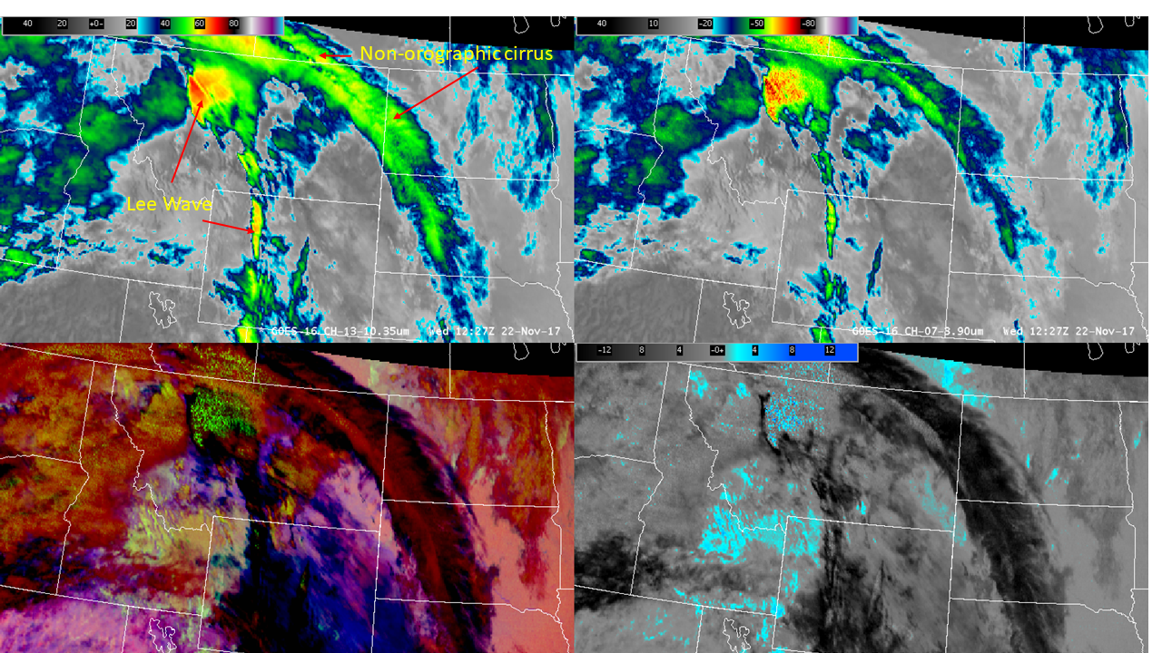
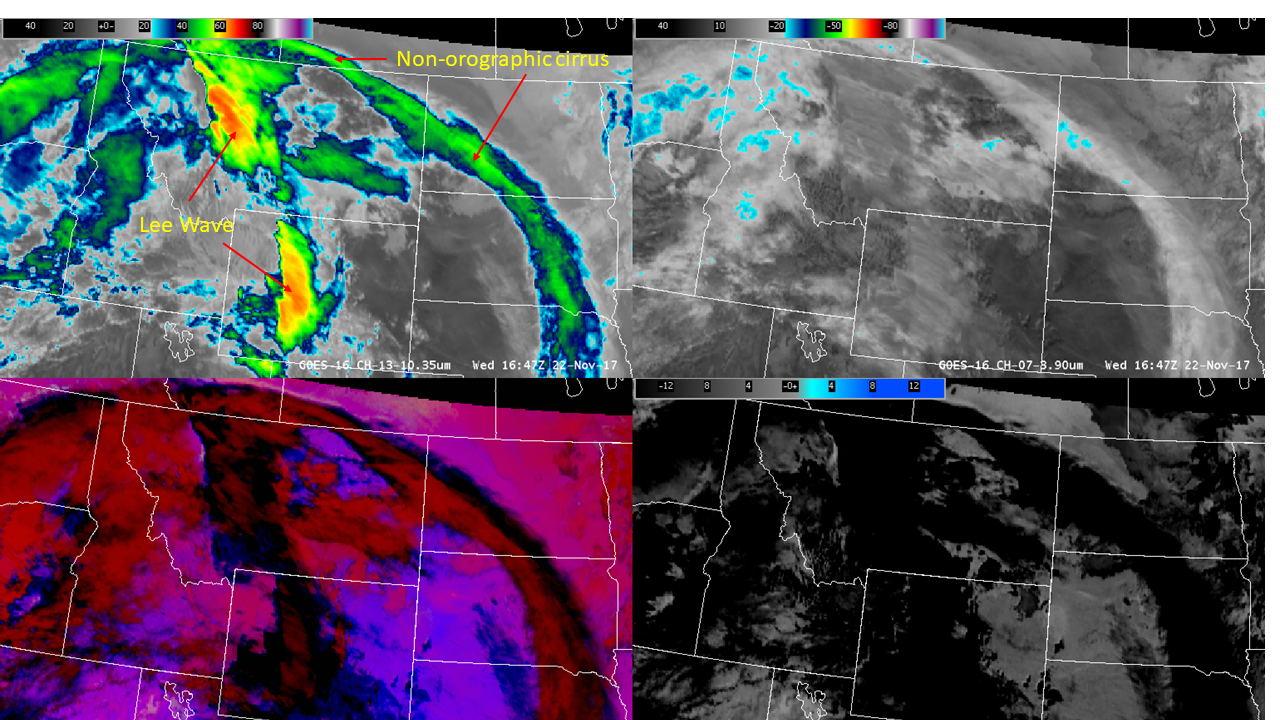
On 22 November 2017, lee wave clouds (also referred to as orographic cirrus) developed downwind of various mountain ranges in Montana and Wyoming. GOES-16 10.3 micron imagery does an excellent job of capturing these lee wave clouds as regions of exceptionally cold brightness temperatures. The following 4 panel display of GOES-16 imagery depicts:
Upper left: 10.3 micron (band 13)
Upper right: 3.9 micron (band 7), same color table as band 13
Lower left: Nighttime microphysics RGB (Red: 12.3 – 10.3 microns; Green: 10.3 – 3.9 microns; Blue: 10.3 microns)
Lower right: Fog product (10.3 – 3.9 micron)
This loop spans 1122 to 1757 UTC, therefore the appearance of the imagery transitions between nighttime and daytime, which is very important to note for any imagery/products that contains the 3.9 micron band. One prominent feature of the 3.9 micron band is that all clouds, both liquid and ice, will exhibit an approximate 20 degrees Celsius increase in temperature when the sun rises over them during the early morning hours. That is, during the daytime, a significant solar reflected component increases 3.9 micron brightness temperatures. The terminator can be seen best in the fog product centered around 1417 UTC.
There are a mix of orographically induced lee wave clouds (easy to spot since they are locked to the terrain) along with what may be referred to as “synoptic” scale cirrus that is advecting along and is not locked to the terrain, an example of the different types of cirrus is shown here annotated on the 10.3 micron image at 12:27 UTC; the other 3 images are there for reference.

Prior to sunrise, lee wave clouds in Montana exhibited their initial development. Lee wave clouds in Montana began to develop around 11:47 UTC. By 12:27 UTC, brightness temperatures at 10.3 microns were very cold, around -70 degrees Celsius, as the lee wave clouds expanded (see top left image above). The non-orographic cirrus, annotated in 10.3 microns, exhibit cold brightness temperatures, around -45 degrees Celsius (see top left image above). Prior to sunrise, the solar contribution to 3.9 micron brightness temperatures is missing; consequently, brightness temperatures at 3.9 microns (top right image above) are similar to those at 10.3 microns. In sharp contrast, the appearance of the lee wave clouds, in Montana, in both the nighttime microphysics and fog products appear contrary to clouds composed of ice. As indicated above, green in the nighttime microphysics RGB comes from the 10.3 minus 3.9 micron temperature difference, which is the fog product. Therefore, green in the nighttime microphysics RGB (bottom left) and light blue in the fog product (bottom right) is a liquid cloud signature. However, brightness temperatures are between -45 and -70 degrees Celsius; temperatures that are much colder than the homogeneous freezing temperature. An apparent dilemma exists: both 10.3 and 3.9 micron brightness temperatures suggest ice clouds while both nighttime microphysics RGB and fog products suggest liquid clouds. How could this be?
Unfortunately, both the greenish color in the nighttime microphysics RGB and the bluish color in the fog product over Montana are “false signals” (i.e., anomalous from what is expected). There are 2 possible explanations for the “false signal” in each product. First, temperatures at 3.9 microns are cold enough to allow noise to appear in imagery. Secondly, the existence of relatively small ice particles. Appearances change however when the terminator passes by and the sun shines on the scene.
At 16:47 UTC, the terminator passed by and the sun is shining on the scene shown in all 4 panels in the figure below.

Due to solar reflection off of all types of clouds, brightness temperatures at 3.9 microns have increased approximately 20 degrees Celsius. Consequently, brightness temperatures at 10.3 microns (upper left) are much colder than brightness temperatures at 3.9 microns (upper right); therefore, the appearance of 10.3 and 3.9 microns are quite different during the daytime compared to nighttime. In particular, the false signature disappears as a consequence of brightness temperatures increasing at 3.9 microns relative to 10.3 microns (lower 2 panels). Hence, ice clouds appear black in the fog product (lower right). There is a difference, however, in the brightness temperatures of the lee wave clouds in Montana and Wyoming compared to all other ice clouds at 3.9 microns. Research has shown that smaller ice particle sizes reflect more solar energy than larger ice particle sizes. Thus, the existence of relatively small ice particles can explain the warmer brightness temperatures at 3.9 microns of the lee wave compared to all other ice clouds (including the non-orographic cirrus). GOES-16 allows us to observe these characteristics of lee wave clouds, which are important forecast considerations in temperature forecasting. When very cold clouds exist at night, use 10.3 microns rather than 3.9 micron imagery (or product that uses the 3.9 micron band) due to significant noise in the 3.9 micron band.
