High cloud obscuration during a lake-effect snow event
When analyzing satellite imagery during lake-effect snow events, one is interested in looking at the low-level clouds associated with the snowbands. However, sometimes high clouds obscure the low-level clouds making analysis from a satellite imagery perspective more challenging. An example of high cloud obscuration can be seen in this GOES-16 loop from 2 January 2018:
Upper left panel: Day Cloud Phase Distinction RGB product (R: 10.35 um, G: 0.64 um, B: 1.61 um)
Upper right panel: Visible (0.64 um)
Lower left panel: IR (10.35 um) with default color table
Lower right panel: IR (10.35 um) with alternate color table for winter
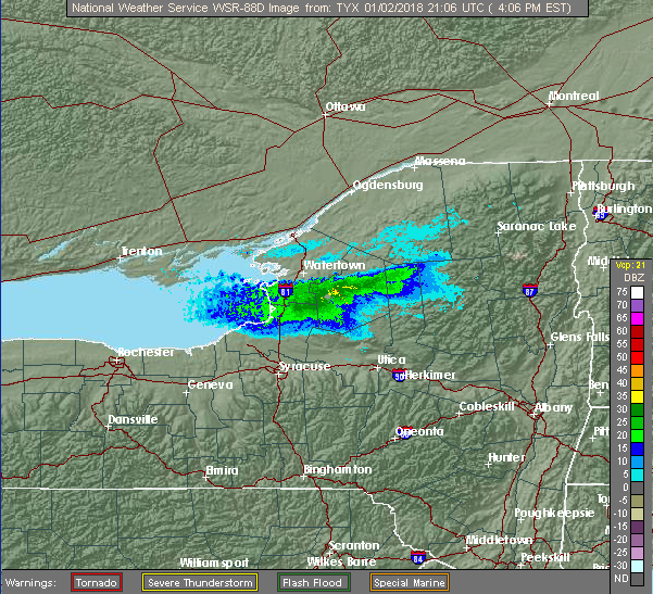
In the first half of the loop, there exists considerable high cloud cover which shows up quite well in the IR imagery as the colder cloud tops, and in the visible imagery as cirrus clouds moving in a different direction than the low-clouds over the lakes. In the later half of the loop, there is less high cloud obscuration over Lake Erie where the lake-effect snow band can be easily seen. Over Lake Ontario, there is much more high cloud cover to obscure the band, however by late in the loop the high cloud coverage is less over the western and south central portions of Lake Ontario. This can be most easily seen in the Day Cloud Phase Distinction RGB product since high clouds stand out as red (colder, thus more red gun (10.35 um) contribution). The low clouds associated with the lake-effect snowbands show up well in the visible band, thus appear light color in combination with the 1.6 um band. The RGB product gave indications of the presence of the lake-effect snowband, which can be confirmed with this radar reflectivity image which shows a significant lake-effect snowband:

At times during lake-effect snow events, the clouds of most interest can be obscured with high clouds, therefore it is important to know what other satellite products are available and may be of use in determining where lake-effect snowbands exist. Also, be aware of alternative techniques for viewing the imagery, on the animation above, click on rock and turn up the loop animation speed. Can you delineate the low-clouds associated with the lake-effect snowband more easily?
