Hurricane Aletta
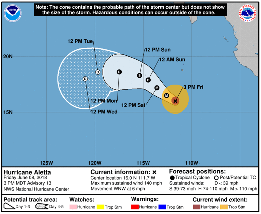
Hurricane Aletta has grown tremendously over the past 24 hours, and it is now determined as a Category 4 hurricane, as of this morning, 8 June 2018. Aletta is currently located southwest of Mexico, in the eastern Pacific Ocean. Aletta is moving northwestward, and is forecasted to drop in intensity by the weekend, as the system moves into higher wind shear, colder sea surface temperatures and decreasing ocean heat content. Aletta is quite large in areal extent, where preliminary reports had the ‘eye’ of the storm at approximately 20-miles in diameter. The latest National Hurricane Center (NHC) forecast track of Aletta is seen below, valid at 3pm MDT, 8 June 2018.

Satellite imagery observing Hurricane Aletta is also provided. Below is the Advected Layered Precipitable Water (ALPW) product at 18Z, 8 June 2018, highlighting the areal extent and the moisture profile of the hurricane. Product is derived from a Microwave Integrated Retrieval System (MIRS), derived from polar-orbiting satellites, and is at a 16-kilometer resolution.
The ALPW product identifies, where the moisture is predominately concentrated within four layers (i.e. thicknesses) of the atmosphere: surface-850mb, 850-700mb, 700-500mb, and 500-300mb. In the image below, the color bar is uniform across all layers, where 0-3 inch precipitable water values are seen. For this event, the majority of the precipitable water is found near the surface, where precipitable water values are ~1 inch (orange, red colors), and values decrease aloft. Black colors within Hurricane Aletta, indicate ‘missing data’, where microwave retrievals can be made within cloudy regions, however, not through areas of precipitation.

Additionally, here is the latest RAMMB-SLIDER satellite imagery of Hurricane Aletta, using GOES-16, 0.64um, visible satellite imagery near 21Z, 8 June 2018. Click on the following animation.
For the latest updates on Hurricane Aletta, click the following link.
