Hurricane Lane
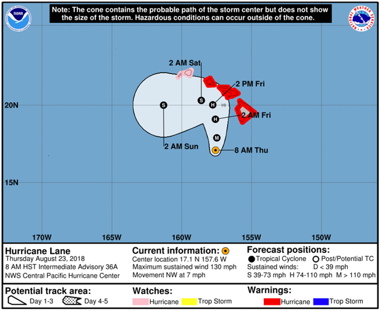
Hurricane Lane is making headlines this week, as the storm approaches the Hawaiian islands. As of the latest National Hurricane Center (NHC) update (8 am HST, 23 August 2018), Lane is moving quite slow, with a northwest movement at ~ 7 miles per hour. Within the last day or two, Lane has weakened, but is still a Category 4 hurricane that can bring heavy precipitation, high winds, storm surge and coastal flooding. Some parts of the Hawaiian islands have experienced heavy precipitation already, and more is expected, throughout the next few days. As seen in the NHC image below, the forecasted track shows the ‘probable path’ of Hurricane Lane, but does not indicate the magnitude of the storm. The forecasted track is subject to change.

The Suomi-National Polar-orbiting Partnership (S-NPP) satellite observed Hurricane Lane via Near-Constant Contrast (NCC) product, earlier this morning at 1228Z, 23 August 2018. The NCC is a derived product of the Day/Night Band (DNB) sensor, that illuminates atmospheric features and senses emitted and reflected light sources (i.e. cloud cover and cloud convective tops from Lane) during the nighttime. In the NCC image, notice the large areal extent of Hurricane Lane, as the northern/northeastern periphery of the storm has reached the southern shores of the Hawaiian islands, bringing heavy precipitation rates.

In complement to the NCC, the CIRA -Advected Layered Precipitable Water (ALPW) product (shown below), derived from microwave retrievals, shows high precipitable water values of Hurricane Lane, as the storm moves northwestward. The ALPW product is partitioned into 4 layers, to identify where most of the moisture lies within the atmosphere, and indicates the horizontal moisture distribution. In the animation below, ALPW highlights ‘surface-850mb layer’ precipitable water values, where high values are concentrated within and near Hurricane Lane (orange, dark orange colors), indicating areas that could experience heavy precipitation. Precipitating regions are indicated as ‘missing data’, represented by black colors in the imagery, since microwave retrievals are made in cloudy regions but not precipitating regions. Animation is from 18Z, 22 August 2018 to 15Z, 23 August 2018.
For the latest updates on Hurricane Lane, click on the following NHC link.
