Hurricane Florence
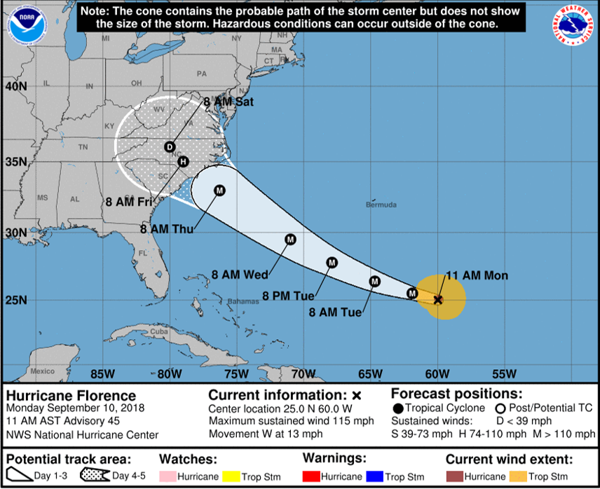
The hurricane season in the Atlantic has been quite inactive throughout the majority of the summer, until this past week. Currently there are three active hurricanes located in the eastern, central and western Atlantic Ocean, named Hurricane Helene, Isaac, and Florence, respectively; all with varying magnitude, intensity, and storm tracks. However, with all the present activity, we will focus our sights on Hurricane Florence, since Florence can have major impacts (i.e. flooding, high winds, storm surge and potential power outages) along the southeastern United States. According to the latest forecast models and National Hurricane Center (NHC), Hurricane Florence appears to make landfall along the Carolinas, Thursday morning, 13 September 2018, although the storm track is subject to change, since it is only Monday, 10 September 2018. Refer to the NHC product below. Note that Florence is anticipated to become a Major Hurricane (i.e. hurricane greater than 110 mph) as it makes landfall later in the week.

The Suomi-National Polar-orbiting Partnership (S-NPP) satellite observed Hurricane Florence early this morning at 0505Z, 10 September 2018, using the Near-Constant Contrast (NCC) product. For unaware readers, NCC is a derived product of the Day/Night Band (DNB) that utilizes a sun/moon reflectance model that illuminates atmospheric features, and senses emitted and reflected light sources during the nighttime (i.e. a ‘nighttime visible’ product). Note the NCC imagery is taken during the new moon phase of the lunar cycle, where atmospheric features are still seen in the imagery due to an atmospheric phenomenon called ‘atmospheric nightglow’.
NCC captured the large areal extent of Hurricane Florence, along with the eyewall, circulating clouds and rain bands. Lightning was also observed on the southern side of the hurricane, denoted by the horizontal white streaks. Streaks are produced due to the time discontinuity between the satellite overpass (i.e. on the order of seconds) and the duration of the lightning strike (i.e. on the order of milliseconds).

Below, is a CIRA ALPW surface-850mb animation of the hurricane activity in the Atlantic Ocean between 18Z, 9 September 2018 to 15Z, 10 September 2018. The ALPW product highlights the precipitable water (i.e. a quantifiable measure of how much water vapor is in an atmospheric column) within four layers of the atmosphere (i.e. surface-850mb, 850-700mb, 700-500mb, and 500-300mb). Notice the high precipitable water values with each hurricane (i.e. indicating the horizontal moisture distribution and indicate areas that are favorable for heavy precipitation) as the hurricanes move westward through time.
For the latest updates on Hurricane Florence, click the following link.
