WS Harper Impacts on Northeast US
As Winter Storm Harper passed through the northeast United States, the storm brought heavy precipitation in the forms of snow, rain, and freezing rain that produced significant ice accumulation on the ground. Storm total snowfall, rainfall and ice accumulations were observed in Connecticut, Massachusetts, and Rhode Island. Specifically snow and ice accumulations ranged from 1-11 inches, and a trace-to-0.3 inches of ice respectively. Both accumulations on the roads, along with localized flooding from heavy rain can be hazardous to travelers. To access the storm observation reports, refer to the following NWS ‘Public Information Statement’ link.
The snow and ice accumulations were also observed from geostationary and polar-orbiting satellites, taken from before the storm (17 January 2019), and after the storm (21-22 January 2019).
Before the Storm: GOES-16, Band 5 – 1.6um @ 13-21Z, 17 January 2019
Geostationary imagery (i.e. animation) is at 1-kilometer spatial resolution, where the 1.6um spectral band is used. 1.6um, also known as the ‘Snow/Ice Band’, discriminates between the refraction components of water and ice. In the imagery, users would see liquid water clouds appearing bright, while ice clouds and ice accumulation on the ground (i.e. via snow or ice accumulation produced from freezing rain) will appear significantly darker. This is due to that ice absorbs radiation in 1.6um, where liquid water clouds reflect radiation at 1.6um. Also in 1.6um, land surfaces and bodies of water (i.e. lakes and ocean) exhibit great contrast as well. The animation below is before the storm, where it is used as a reference for readers. Notice no dark swaths of ice are observed in the states of Massachusetts, Connecticut and Rhode Island.
After the Storm: GOES-16, Band 5 – 1.6um @ 13-21Z, 21 January 2019
After the remnants of Winter Storm Harper passes through the New England area, notice an elongated, horizontal, dark swath observed in the imagery. Notice the dark swath earlier in the day, before mid-to-high level clouds obscure the surface features. Refer to the imagery inside the yellow ellipse.
After the Storm: GOES-16, Band 5 – 1.6um @ 13-21Z, 22 January 2019
The very next day is also explored, since the day predominately encapsulates a cloud-free atmosphere, before high-level cirrus clouds move over the domain. The dark swath can be seen throughout portions of Connecticut, Massachusetts and Rhode Island.
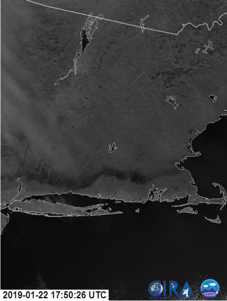
After the Storm: NOAA-20, I-3 Band – 1.6um @ 1750Z, 22 January 2019
Need a better spatial resolution of the dark swath? Refer to polar-orbiting satellite imagery. NOAA-20 VIIRS imagery data is produced at 375-meter spatial resolution, and provides more detailed surface features, although the temporal resolution of polar-orbiters are infrequent.

Social media highlighting the ice accumulation can be seen via the following links: photo, and video.
