Arctic Blast in the Upper Midwest
A cold arctic air mass moved into the Upper Midwest the past two days (29-30 September 2019), providing extreme cold temperatures for several states, including North Dakota, Minnesota, Wisconsin, South Dakota, Iowa, and Illinois. Along with high winds, the calculated, respective, wind chills are even lower.
Satellite imagery, comprised of polar-orbiting and geostationary data, along with surface and upper air observations are used to demonstrate how cold it was for this portion of the United States. Images are provided between 29-30 January 2019.
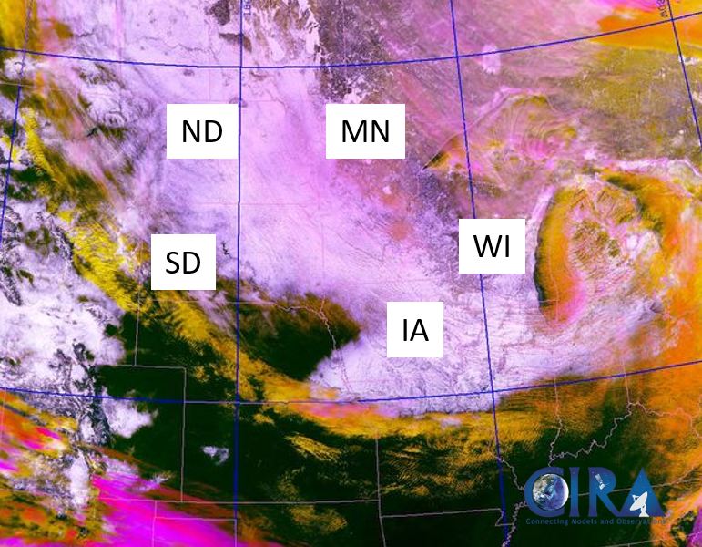
VIIRS Snow Cloud Discriminator: 1902Z, 29 January 2019
The VIIRS Snow Cloud Discriminator product (below) differentiates between snow cover (white), bare ground (dark green), and low (yellow) – to – mid (orange) – to – high (pink) level clouds. Additionally, state abbreviations seen in the imagery are as follows: SD – South Dakota, ND – North Dakota, MN – Minnesota, WI – Wisconsin, and IA – Iowa. The static image shows the large areal extent of snow cover that resides in several states, as the arctic air mass advects over the domain. In addition to the cold arctic air mass, snow cover played a role in the extreme, cold air temperatures observed in the Upper Midwest from 29-30 January 2019. To re-enlighten readers, snow cover traps longwave radiation (i.e. in the form of heat) that the Earth emits, and as a result, during the nighttime, near-surface air temperatures are predominately colder, since there is limited heat exchange between the surface and the atmosphere.

GOES-16 10.3um: 2147Z 29 January 2019 –> 1607Z 30 January 2019
The animation below, shows infrared geostationary data, displaying cold brightness temperatures (ranging from -30C to -50C, light-to-dark blue and green colors) moving over the Upper Midwest. Notice how the cold air advection moves slowly southward, and appears slightly different in texture than cloud cover; cold air appears more smooth and uniform, than the rough, defined features of cloud cover. Additionally, cloud cover also develops and dissipates quickly over time, albeit, shows similar brightness temperatures to near-surface cold air. Note how the cold air extends all the way south to the Missouri/Iowa border, then stars to recede northward, when daytime solar heating begins (~13Z, 30 January 2019). The cold air extent also matches approximately to the snow cover extent observed by the VIIRS Snow Cloud Discriminator.
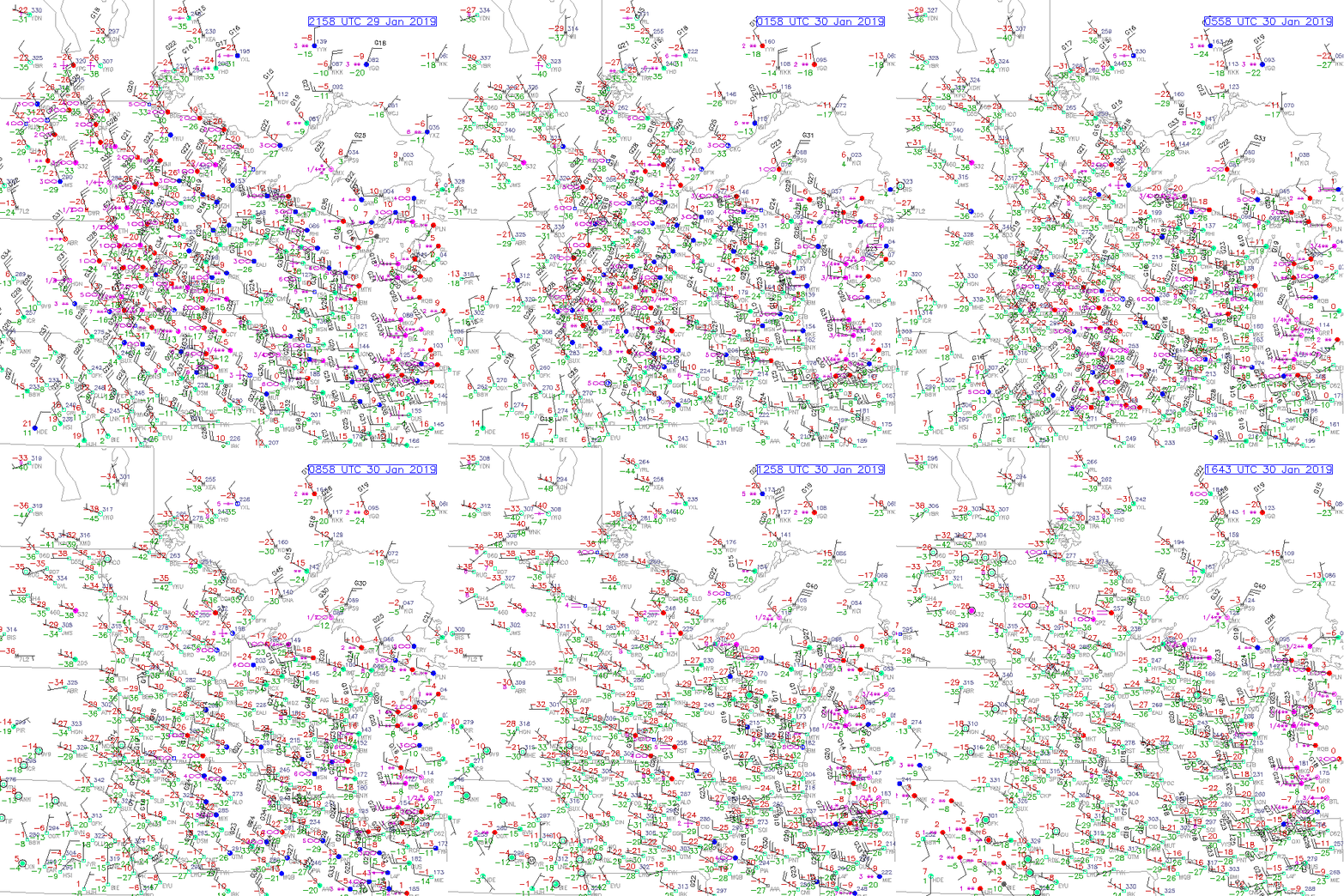
Surface Observations: 2158Z 29 January 2019 –> 1643Z 30 January 2019
Furthermore, surface observations (provided from RAP Real-Time Weather) show the cold air advection from the event. Notice the strong northwesterly winds move through the domain, throughout time, and note the surface air temperatures (-40F or below, observed by some locations).

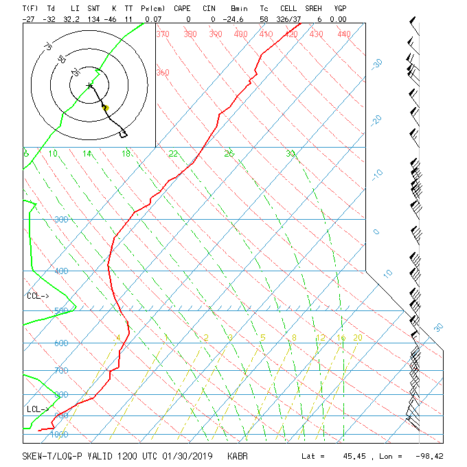
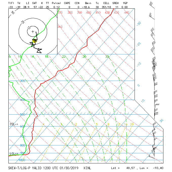
RAOB Soundings: KABR and KINL –> 12Z, 30 January 2019
To get an idea of how cold the air was not only at the surface, but aloft, one can refer to RAOB temperature and moisture soundings. Soundings below are both at 12Z, 30 January 2019, where the first sounding is from Aberdeen, SD (KABR), and the second is from International Falls, MN (KINL). Notice, how deep the arctic air mass is from Aberdeen, SD; the air mass extends from the surface – to ~550mb thick!


For interested readers, a Minneapolis, MN social media post of the event can be seen at the following link.
