4 February 2019 significant ice storm in the Upper Great Lakes
On 4 February a shortwave tracked across the Upper Great Lakes towards the east, ahead of the shortwave, anomalously high moisture at low to mid-levels existed which contributed to a historic ice storm for the region.
The NWS forecast office in Marquette, MI has a great web-page summarizing this event including pictures and the meteorological environment:
This blog entry will focus on various satellite imagery and products, particularly those that highlight the anomalously high moisture for this event.
We lead off with a synoptic scale perspective of this event with the 3 Water Vapor bands from GOES-16 along with the Air Mass RGB:
The imagery clearly shows a shortwave in the North Dakota / Minnesota vicinity moving eastward. Ahead of this shortwave, precipitable water values were anomalously high, in fact record breaking TPW values were observed for this time of year in the Upper Great Lakes. The anomalously high precipitable water values can be seen in the Advected Layer Precipitable Water product for the various layers. Moisture plumes are observed with origins from the Gulf of Mexico in the SFC-850, 850-700 and 700-500 mb layers. This shows that the moisture was relatively deep, particularly for this time of year in the Upper Great Lakes region.
An experimental product at CIRA that is still under development is the model minus ALPW PW for each layer. For example, the HRRR minus ALPW PW for a given layer shows the difference between observations from ALPW versus different HRRR 3 hour forecasts (4 panel shows the same layer arrangement as the ALPW loop above). We primarily see positive values in the Upper Great Lakes region ahead of the shortwave, meaning that there’s more moisture in the HRRR 3 hour forecast compared to ALPW observations. A similar theme exists for the GFS (these are also 3 hour forecast fields).
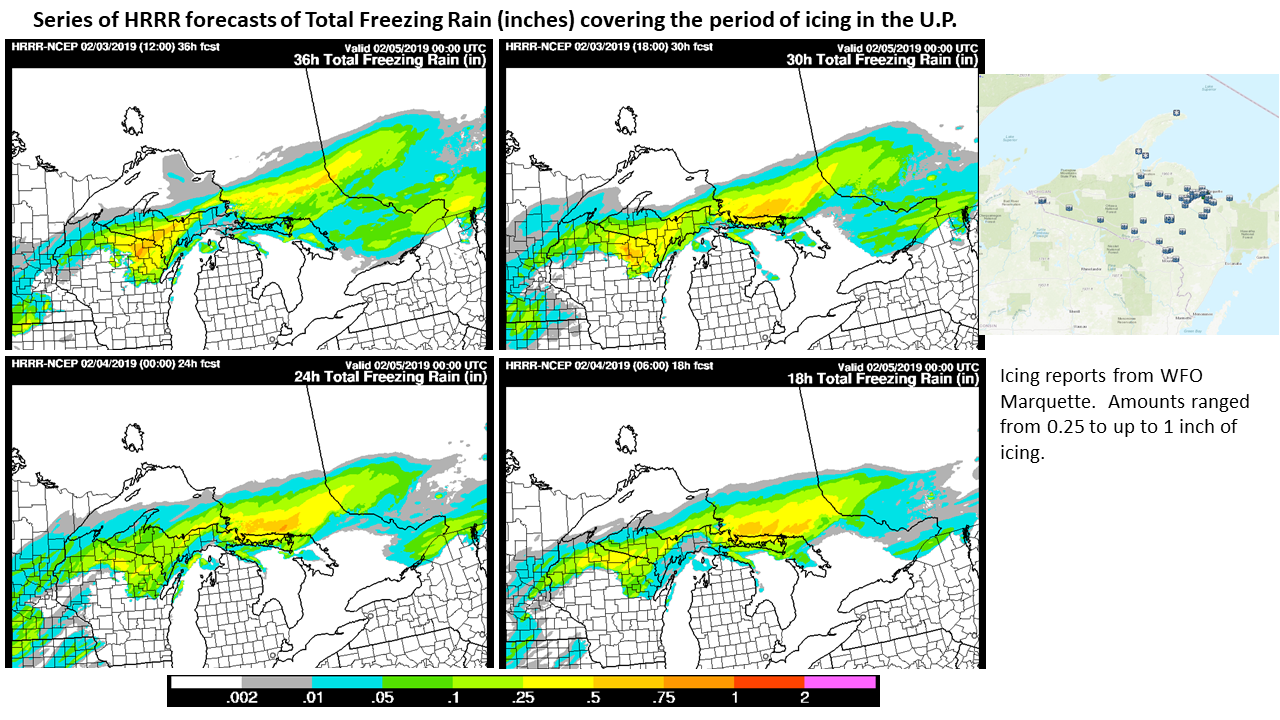
Interestingly, the HRRR forecast a substantial ice storm, as seen in this set of forecasts:

The anomalously high precipitable water played a key role in contributing to a historic ice event for this region, which typically observes snow during precipitation events this time of year.
The ALPW product is available in AWIPS from CIRA via LDM, however the model minus ALPW difference fields are not available since these are still in an experimental stage.
