Radar and satellite ‘snowfall rate’ observations
Forecasting snowfall and snowfall rates can be quite challenging, especially in radar-limited and or radar-deprived regions. A polar-orbiting satellite ‘Snowfall Rate’ product can be used together with radar observations to help anticipate snowfall rates, identify snowfall areal extent and snowfall maximas. To highlight the product’s capabilities, refer to the following snowfall case event over Northern Colorado, between 3-15Z, 2 March 2019 comprising of surface, radar and satellite observations.
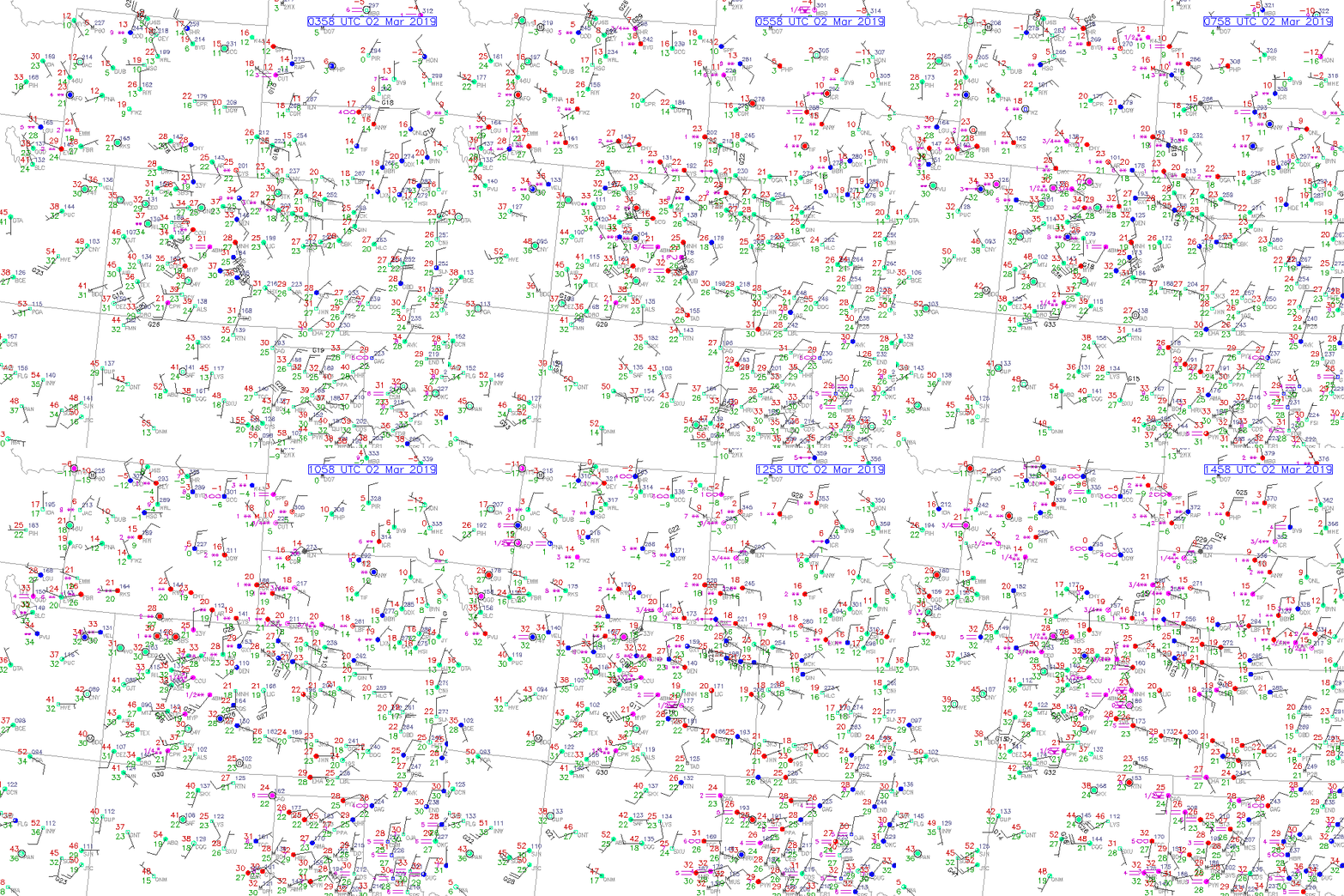
Surface Observations over Northern Colorado from 3-15Z, 2 March 2019.
The 13-hr loop shows a decrease in air temperatures across Northern Colorado, exhibiting below-freezing temperatures. Over time, notice a surface low develop, just north of Denver, CO as southeasterly, upslope flow moved into the area. Additionally, the surface low in complement with an upper-level jet maxima (not pictured) and an increase in low-to-mid level moisture, produced enhanced snowfall totals over Northern Colorado.

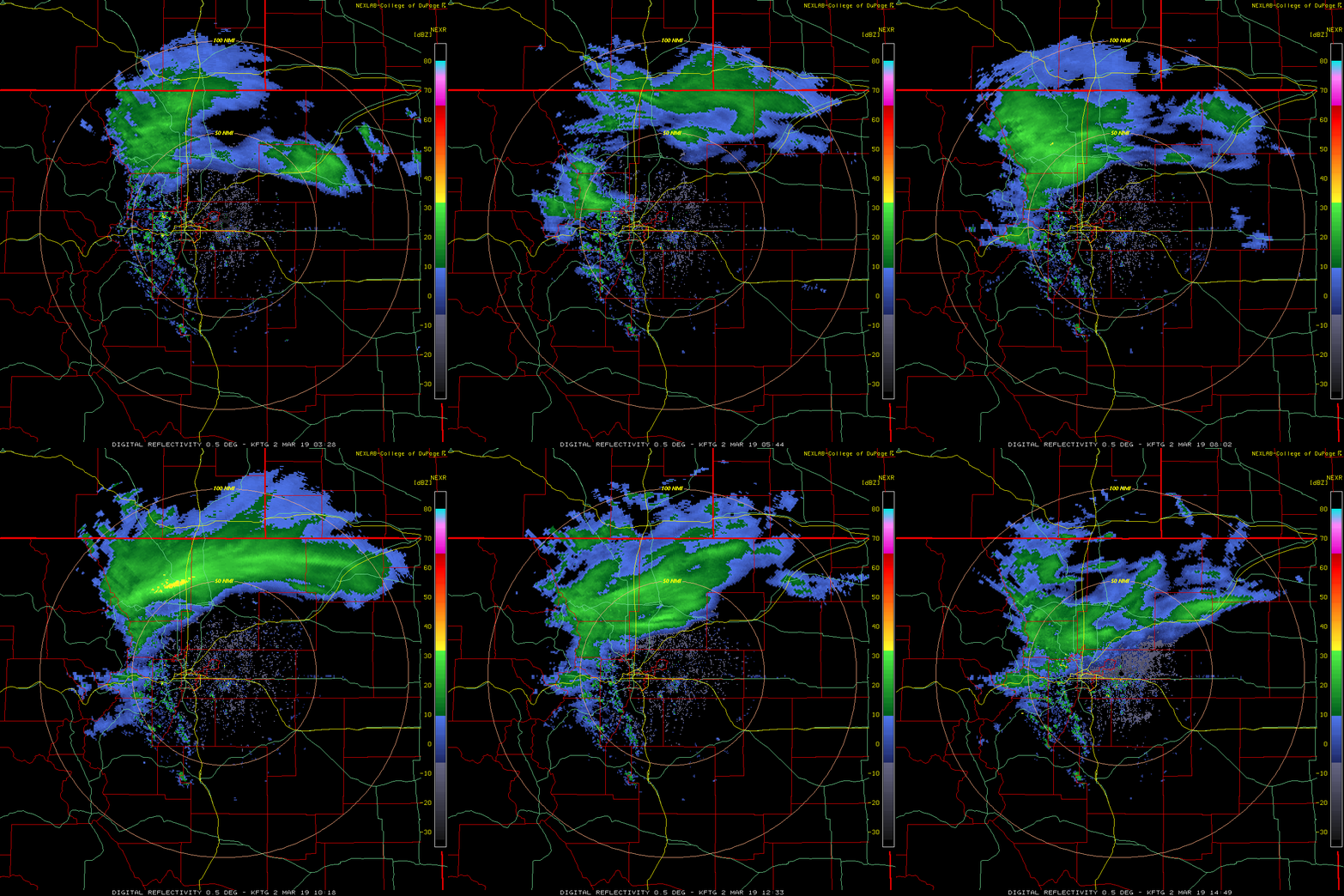
Radar observations over Northern Colorado from 3-15Z, 2 March 2019.
Base Reflectivity radar observations (via Denver radar from the COD website) during the same time period, shows the evolution of higher reflectivity values (between 15-35 dBZ) observed over Northern Colorado. Notably from 11-13Z, a bright ‘snow band’ (an elongated reflectivity maxima) was observed, indicating heavy precipitation, or in this case, heavy snowfall over Larimer and Weld counties. But what snowfall rates are being observed? This is where the Snowfall Rate (SFR) product can be utilized.

Collocated Snowfall Rate (SFR) product and Radar Observations at ~11Z, 2 March 2019.
The SFR product is derived from passive microwave observations via polar-orbiting satellites, where SFR observations are displayed in units of liquid equivalent ‘inches per hour’. The image below is a direct comparison of SFR in relation to the radar (albeit, offset by two minutes) at ~11Z, 2 March 2019. Notice the line of higher liquid equivalent snowfall rates (0.04-0.1 inches per hour) correspond well with the bright ‘snow band’ seen in the radar. Additionally, the SFR product has the ability to observe the snowfall rate areal extent, seen throughout Wyoming, Nebraska and South Dakota via 1 satellite swath (i.e. DMSP). In contrast, the Denver radar exhibits a limited range, where an adjacent radar needs to be utilized to see snowfall occurring in nearby domains (i.e. users would need to refer to the Cheyenne, WY or North Platte, NE radars).

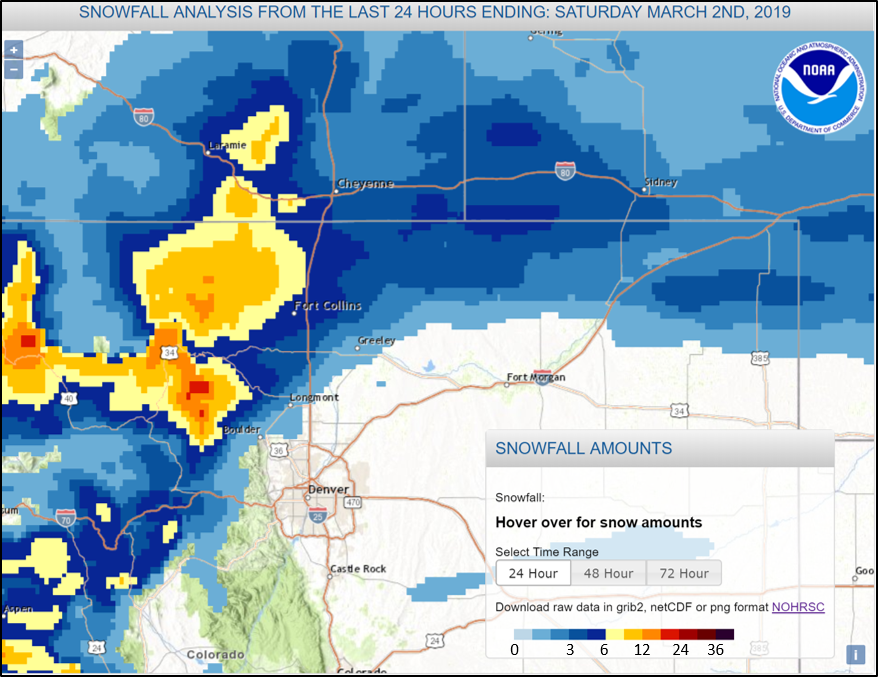
Snowfall Analysis and snow totals (ending ~9AM MST, 2 March 2019).
Via NWS/NOAA snowfall analyses, note the snow totals from this event, ranging from 0-6 inches at low elevations, and 6-plus inches at higher elevations.

For interested readers, NASA-SPoRT has an additional product, denoted as the Merged SFR product (i.e. incorporates radar and SFR together) that can be accessed online via the following link.
