Polar orbiting and geostationary lake ice monitoring
Monitoring lake ice coverage over the Great Lakes via satellite is vital and affects shipping industries, tourism and recreation, especially over the winter months when ice develops, grows and expands over the lakes. According to the Great Lakes Surface Environmental Analysis (GLSEA) and NOAA CoastWatch, the total ice coverage between all 5 lakes is 80% as of 8 March 2019. GLSEA and NOAA CoastWatch’s diagram below highlights lake ice coverage (i.e. ice depicted as grey, dark grey and black colors) and the areas of open water seen via different shades of blue (i.e. represented via water temperatures, ~0°C-5°C).

Satellite observations, combined with other data sets, are vital in producing ice coverage percentages over the Great Lakes. On 8 March 2019, under moderate clear-sky conditions, polar-orbiting and geostationary satellites observe the Great Lakes at high spatial resolution. Note, geostationary observations express high temporal resolution as well, however polar-orbiting observations exhibit coarser temporal resolution. Satellite imagery and products are shown below and are provided from RAMSDIS Online, CIRA SLIDER and RealEarth.
S-NPP Day/Night Band (DNB) – Solar Reflectance (0.7um) at 1850Z, 8 March 2019
DNB solar reflectance acts like ‘daytime visible imagery’ (i.e. 0.64um) where DNB’s satellite sensor observes the solar reflectance from atmospheric or surface features that exhibit high albedos. DNB provides imagery (below) at 750-m resolution and shows open water, land, ice and clouds, above and around the Great Lakes. However, how can users differentiate between the aforementioned scene types?

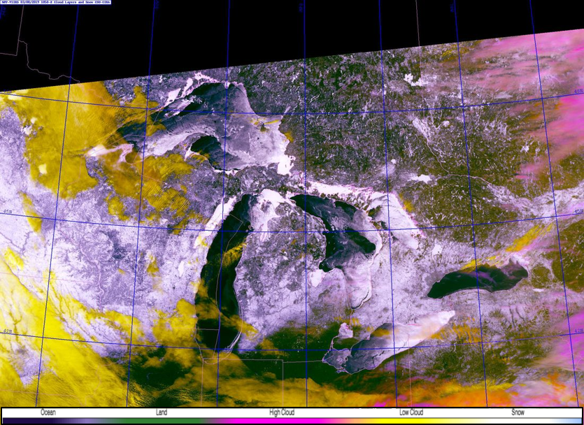
S-NPP VIIRS Snow/Cloud Layers at 1850Z, 8 March 2019
Look no further than to the polar-orbiting VIIRS Snow/Cloud Layers product which is at 750-m resolution. Observing the same domain as DNB, the VIIRS Snow/Cloud Layers differentiates between land (green), snow and ice (white), low (yellow) and high (pink) clouds and bodies of water (dark blue/black).

GOES-16 Snow/Cloud Layers from 1832-1927Z, 8 March 2019
Now incorporate a similar product, except derived from the geostationary satellite, GOES-16, users can observe the Great Lakes at high temporal resolution. Temporal resolution is from the CONUS sector, that is, 5-minute geostationary data. Notice the lake ice movement (i.e. moving white features over the Great Lakes) along with the low and high clouds moving to the east. Lake ice motion can be seen more conspicuously over Lake Huron.
S-NPP VIIRS Flood Detection Product at 1900Z, 8 March 2019
Additionally, another polar-orbiting product that users can observe the Great Lakes and differentiate between surface and atmospheric features, is the VIIRS Flood Detection product. Product is at 375-m resolution, discriminates between different scene types: ice = aqua, supra-snow ice (water on top of ice, or melting ice) = purple, open water = blue, clouds = grey, snow = white, and land = brown. The product also calculates the floodwater fraction percentage from 0-100% (green-red colors) as well. VIIRS Flood product can be accessed in AWIPS-II via LDM.

