The Snowfall Rate (SFR) and merged SFR Products
As of early November 2023, the TOWR-S RPM v24 has been released for National Weather Service (NWS) users to update their local AWIPS terminals with the latest satellite data capabilities. Within the RPM v24 release, more NWS CONUS users will be able to access the Snowfall Rate (SFR) and the merged SFR (satellite plus radar) products in AWIPS.
The SFR product observes the liquid-equivalent, instantaneous snowfall rate over a domain. The product is derived from passive microwave instruments that are on-board polar-orbiting satellites. Users can employ the product to identify the snowfall areal extent and locate regions of the most intense snowfall, which may not be as discernible in the visible and infrared imagery. SFR is also quite valuable in data sparse regions (i.e., areas that lack radar coverage, terrain, etc.), where the product fills in these observational gaps. Note, there are some key attributes to keep in mind while using SFR in operations: the product values are expressed in inches per hour, the spatial resolution varies from 7-16 km at the satellite subpoint, and the temporal resolution is coarse in the mid-latitudes (i.e., ~18 overpasses per day that are not evenly distributed). The polar regions receive significantly more overpasses.
As we scan over CONUS this week, we notice snow falling over the Great Lakes region, where lake effect snow bands engulf the area on 28 November 2023. The SFR product observes the snowfall rates over the region and downwind of the lakes. See the animation below. Notice higher snowfall rates that are observed near and east/southeast of Lake Huron, Erie, and Ontario.
SFR observations from 0633Z – 1937Z, 28 November 2023.
An addition to the SFR product, users will also be able to access the merged SFR product, which incorporates both satellite and radar datasets. The mSFR is a liquid equivalent, instantaneous snowfall rate product, however, it is derived from NSSL Multi-Radar Multi-Sensor System (MRMS) precipitation rate (i.e., snowfall only) data and the SFR satellite data. This unique product provides users a higher temporal refresh rate (~available every 10 minutes), where users can observe the snowfall activity within the range of the radar but also in data-sparse regions. Refer to the animation below that highlights the mSFR observations over the Great Lakes. Notice the swaths of SFR data that are seen infrequently during the time period; users can differentiate between the two datasets based on the pixel size (i.e., the radar data exhibits a finer spatial resolution of 1-km).
mSFR observations from 15Z – 1930Z, 28 November 2023.
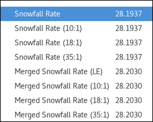
Note, the SFR and mSFR liquid-equivalent (a.k.a., LE, expressed in inches per hour), the 10:1, 18:1, and 35:1 snowfall to liquid ratio products are also available in AWIPS. Refer to the AWIPS menu below that shows the list of available products.

Need to access the SFR and mSFR data online? NOAA/NESDIS/STAR/CISESS provides access to the data over CONUS (SFR and mSFR CONUS). Users can access the SFR data over the Alaska sector as well (SFR Alaska).
Users can check out the latest Satellite Liaison Blog that covers how to observe lake-effect snow events with other types of satellite datasets.
