
Ranger Road Fire
On 17 February 2026, the NWS Storm Prediction Center (SPC) issued an Extreme Fire Weather Outlook for the central and southern high plains, stretching from southwest Nebraska to the Oklahoma and Texas Panhandles. The outlook relayed the increased fire danger over the region, which was forecasted for high winds and low relative humidities. Abundant dry fuels were also present, which if fires were to ignite, that could support rapid fire spread across the domain. During the mid-morning of 17 February 2026, numerous fires erupted over the Oklahoma Panhandle and southwest Kansas. This blog entry focuses on the largest fire that ignited, the Ranger Road Fire. As of 19 February 2026, the fire burned approximately 283,000 acres.
Using the 5-minute, shortwave infrared imagery from geostationary satellites, one can observe the Ranger Road Fire’s initial hotspot (seen at ~1716Z, in white and then red pixels) in the midst of cloud cover overhead. The fire rapidly spreads to the northeast, eventually shifting eastward as a front passes through the region. Also, notice the other fire hotspots nearby, especially the fires near Woodward, OK, where a few structures were destroyed.
GOES ABI 3.9 um from 15Z, 17 February 2026 to 15Z, 18 February 2026
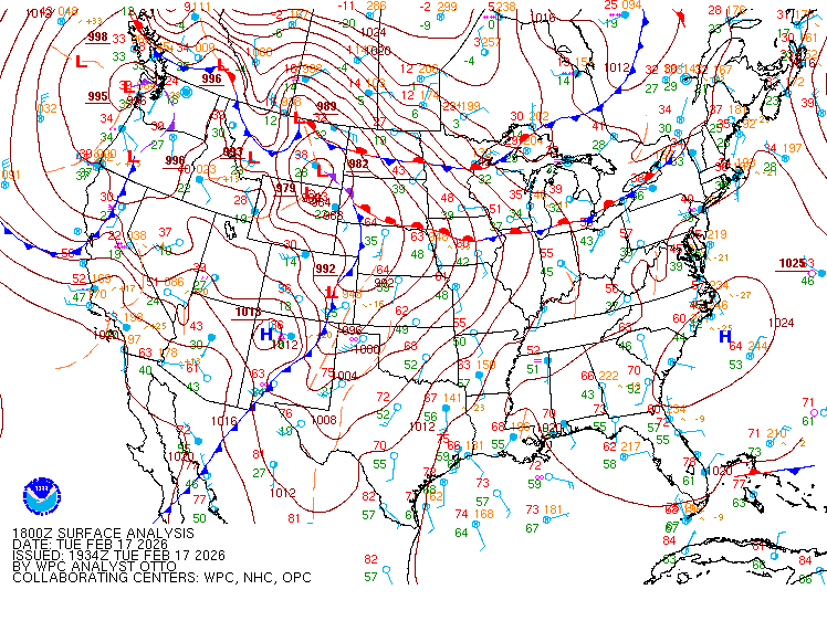
Surface map analysis shows a strong low-pressure system that moved off the Rockies and entered into the northern high plains. As the system moved east, it contained an elongated cold front that extended into the southern high plains, which supported fire spread across Oklahoma and Kansas.
Surface Map Analysis from 18Z, 17 February 2026 to 06Z, 18 February 2026
The VIIRS Fire Temperature RGB estimated the fire intensity of the Ranger Road Fire in a qualitative way. The RGB depicts the fire pixels in red, orange, yellow and white: where white pixels indicate the most intense fires. In the animation below, the fire pixels align with the narrow fire perimeter. Notice, how the fires spread to the northeast, as water clouds (blue) and ice clouds (dark green) move away from the fires.
VIIRS Fire Temperature RGB from 1840Z – 2020Z, 17 February 2026
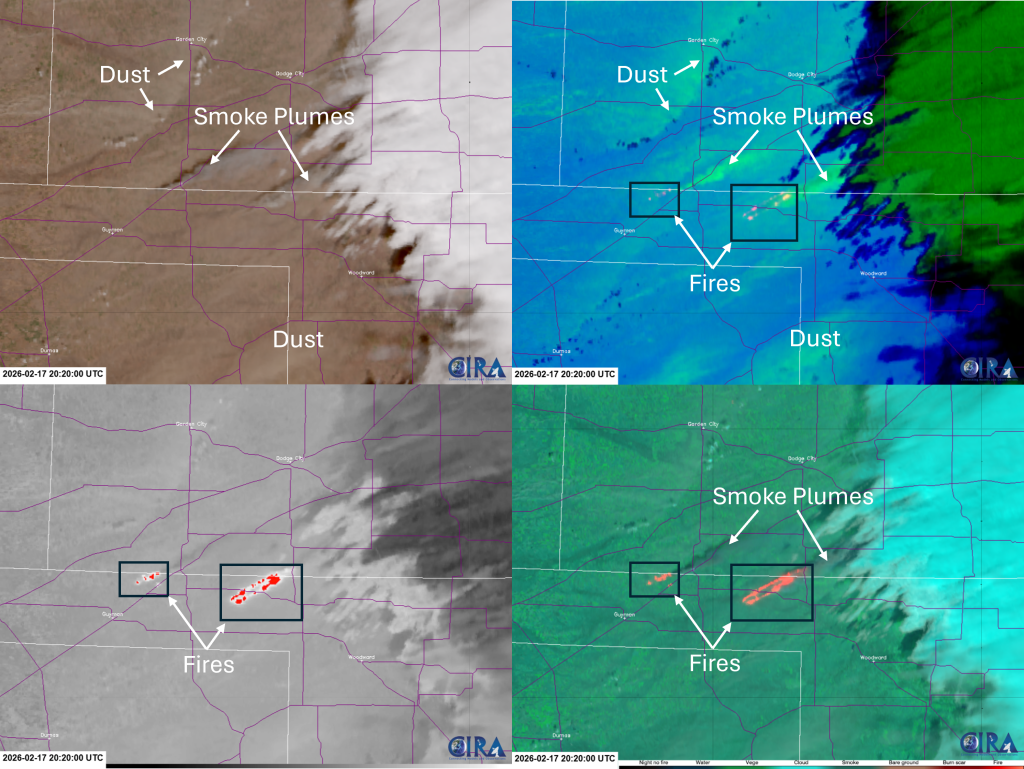
A 4-panel of VIIRS imagery is provided to show the additional data that can be used to view the fire hotspots, the smoke plumes, and dust that was lofted and blown, due to high winds. The 4-panel consists of GeoColor (top-left), Dust-Fire RGB (top-right), 3.7 um (M12), and the Day Fire RGB at 2020Z, 17 February 2026. Labels are provided to indicate some of the features in the imagery.
VIIRS 4-Panel: GeoColor, Dust-Fire RGB, 3.7 um (M12) and Day Fire RGB at 2020Z, 17 February 2026
On 19 February 2026, the burn scar, ash (produced from the Ranger Road Fire), and ambient dust were also captured from geostationary and polar-orbiting satellites. Refer to the CIRA social media link below.