Santa Ana Winds and Dust Identification
It is that time of year again, to observe Santa Ana Wind events for Southern California. On 15 October 2018, an upper-level trough advected into the southwestern United States (i.e. see GOES-16, Upper Level Water Vapor imagery below), produced cold air advection aloft, and brought strong subsidence (i.e. sinking motion) to the surface. The strong subsidence, brought cold, dry, and fast, downsloping winds along the Sierras, towards the coastline. The downsloping winds produced compressional warming, a process that warms the surface air tens of degrees fahrenheit over a short period of time. The following satellite imagery and surface observations of the event are taken between 9-20Z, 15 October 2018.
GOES-16 -> Upper Level Water Vapor (6.2um) : 12-20Z, 15 October 2018
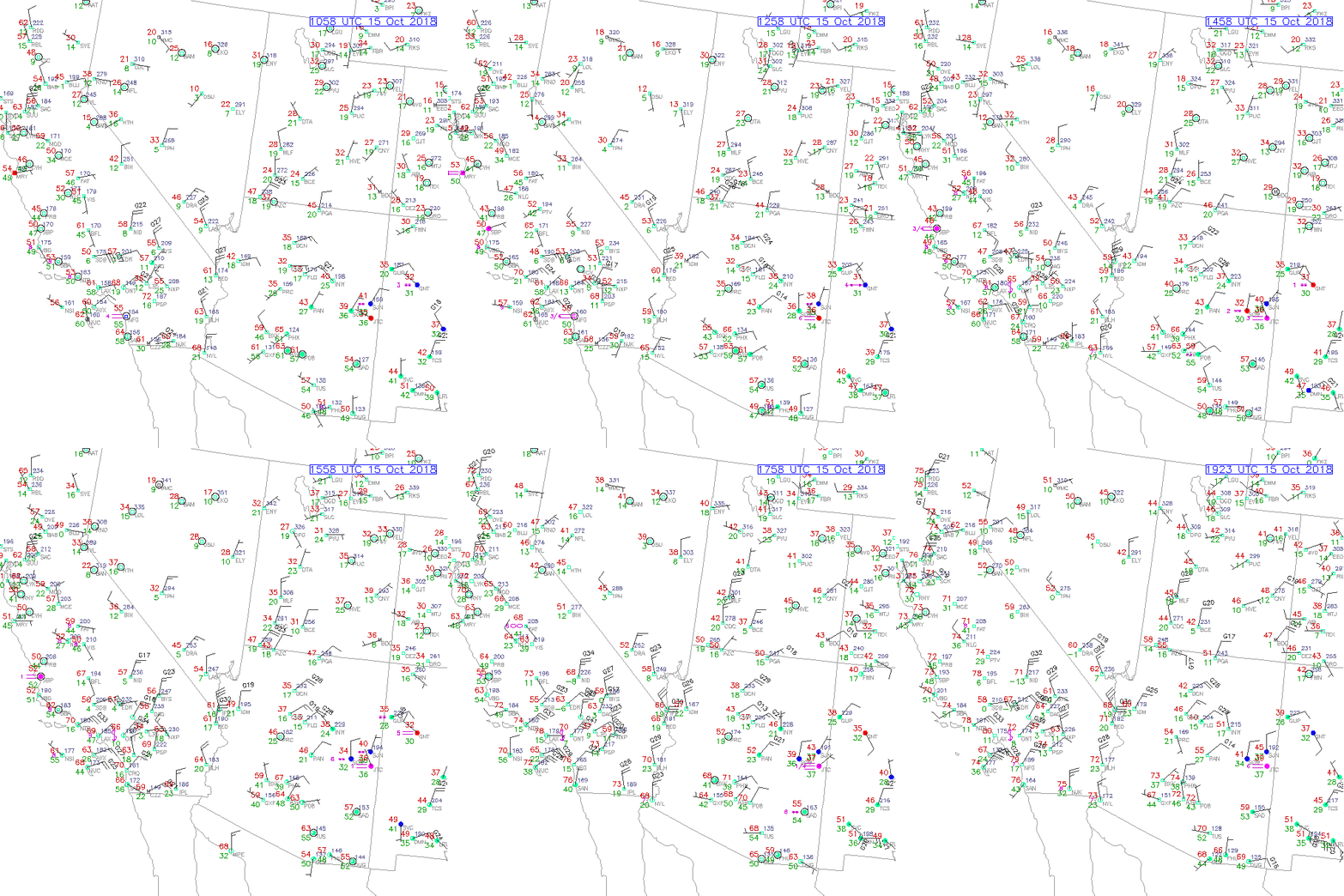
Surface Wind Observations: 10-20Z, 15 October 2018
Note the strong, northeasterly winds in Southern California, with wind gusts over 40 mph. Additionally, notice rapid warming of air temperatures along with a significant decrease in dewpoint temperatures, especially along the coast.

GOES-16 -> Low Level Water Vapor (7.3um): 17-20Z, 15 October 2018
A rapid warming of Brightness Temperatures (BT), represented by pink and yellow colors, advects from northeast-to-southwest bringing warm, dry air to the Los Angeles Metropolitan area. Note, the wave-like patterns produced off of the Sierras create turbulence in the boundary layer, and are hazards for the aviation industry.
Microwave Sensors -> CIRA Advected Layered Precipitable Water (CIRA-ALPW): 9-18Z, 15 October 2018
Another way to see how dry the surface air is, one can use the CIRA-ALPW product, comprised of microwave data. CIRA-ALPW estimates the precipitable water (i.e. moisture content) within a vertical column of the atmosphere. Unlike other precipitable water products, CIRA-ALPW produces precipitable water values within four layers of the atmosphere (i.e. surface-850mb, 850-700, 700-500 and 500-300mb) and utilizes GFS model winds in the algorithm. In the following CIRA-ALPW, surface-to-850mb video, see the moisture gradient, and dry air (i.e. low TPW values) shift southwestward, towards the coastline.
GOES-16 -> Split-Window Difference (10.3um-12.3um): 17-20Z, 15 October 2018
The Split-Window Difference product shows areas of dust, produced by the high winds, seen within the black ellipses. Regions of low-level dust are denoted as negative values, and represented by dark brown signatures. The Split Window Difference product identifies these areas as dust, due to the 10.3um Brightness Temperature (BT) is colder than the 12.3um BT; where silicates in dust are absorbed in 10.3um.
GOES-16 -> GeoColor: 17-20Z, 15 October 2018
In complement to the Split Window Difference product, one can use the GeoColor product to identify dust within the black ellipses. Play the following video. Notice dust over land may not be as discernible to dust advecting over bodies of water. If one is still having trouble identifying dust, focus on the following cities: Long Beach, Mission Viejo, Oceanside, Temecula, the Salton Sea, Ocotillo, and Barstow.
