
Mississippi Ice Storm
During late January 2026, a historic winter storm impacted millions of people across the central and southern United States, producing significant snow, sleet and ice accumulations that led to a flurry of airport delays and cancellations, impassable roadways for motorists, damage to infrastructure, power outages, and cold temperatures. This blog entry focuses on the significant ice (and sleet accumulations) that occurred across Mississippi and adjacent states. The video below captures the devastating impacts in Mississippi, that included widespread downed power lines and trees caused by high amounts of ice accumulation due to freezing rain. Even the University of Mississippi (known as Ole Miss), located in Oxford, MS, was closed for an extensive period of time due to the power outages and travel challenges. Regional snow, sleet and ice accumulation reports can be accessed from the WFO – Jackson, MS and WFO – Memphis, TN webpages.
After the storm passed through the region, the SNPP VIIRS Snowmelt RGB provided a large-scale view of the snow (i.e., dry snow, depicted in light blue), sleet or wet snow (dark blue) and ice (darkest blue) accumulations across several southern states.
VIIRS Snowmelt RGB at 1920Z, 26 January 2026

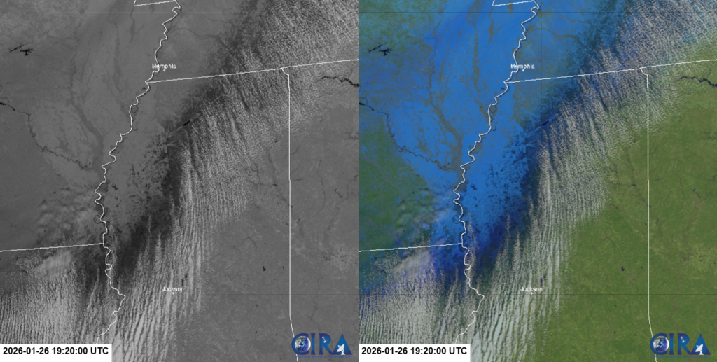
The VIIRS Snowmelt RGB is unique, as it incorporates the VIIRS 1.24 um spectral band within the green spectra of the RGB, and is highly sensitive to snow and ice properties. Additionally, the 1.24 um is not currently available on existing geostationary satellites. A zoomed-in comparison between the 1.24 um and the VIIRS Snowmelt RGB imagery can be seen below. Ice accumulations across the Lower Mississippi River valley stand out in each image and are seen in dark grey/black colors in the 1.24 um imagery and the darkest blue colors within the RGB. Both datasets exhibit 750-m spatial resolutions.
VIIRS 1.24 um (left) and VIIRS Snowmelt RGB (right) at 1920Z, 26 January 2026
This region also experienced numerous power outages. The VIIRS Day/Night Band (DNB) provided a before and after image comparison that shows the emitted city lights that are typically seen across the area, contrasted with the disappearance of city lights after the storm passed through. Notice the significant reduction of emitted city lights (a.k.a., power outages) that can be seen across northeastern Louisiana and rural Mississippi. The impacted areas align with where significant ice accumulations were observed.
VIIRS DNB image comparison: (Before) 28 December 2025 and (After) 27 January 2026
Post storm, a week long VIIRS DNB animation (shown below) observed a few city lights reappearing across the domain. Reflected moonlight also captures snow disappearing and receding towards the north and northwest.
VIIRS DNB: nighttime visible images from 27 January 2026 through 4 February 2026