21 October 2019 – nighttime detection of fog and outflow boundaries
October 21st, 2019 by Dan BikosDuring the overnight hours of 21 October 2019, we analyze multiple applications of GOES imagery at night.
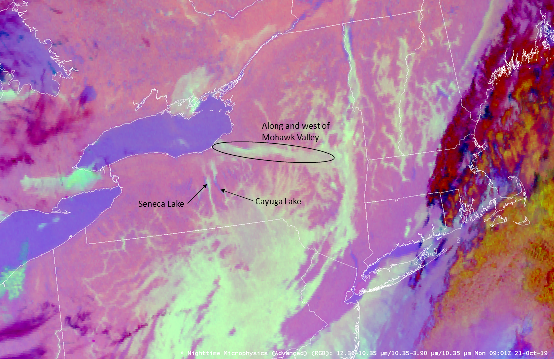
First, we look over the northeast where fog developed. Here is the GOES-16 nighttime microphysics product:
We observe large areas of fog (dull aqua) or low clouds (aqua) in Pennsylvania, New York, Vermont, New Hampshire and Massachusetts. Fog development in river valleys is particularly more easy to identify. Focus in over New York:

where the loop shows the westward movement of fog / low cloud from the Mohawk River Valley westward towards Lake Ontario. We also see the development of fog along Seneca Lake and Cayuga Lake.
Further southwest in Texas, severe thunderstorms developed during the evening hours of 20 October that continued through the overnight hours. The following GOES-16 imagery:
is a 4 panel display:
Upper-left: Split Window Difference / IR (10.3 micron) combination product
Upper-right: Nighttime microphysics RGB
Lower-left: IR (10.3 microns) with the default color table (IR_Color_Clouds_Winter)
Lower-right: Night Fog product (10.3 minus 3.9 micron)
Analyze the southern and western flanks of thunderstorms for regions of outflow (cooler brightness temperatures). Outflow boundaries can be important to analyze for mesoanalysis and potential future convection developing along or interacting with these boundaries.
Which of these imagery / products can you best identify the thunderstorm outflow air mass / boundaries with? Note that in some regions there are low clouds associated with the outflow. The IR imagery with the default color table has less contrast compared to other imagery / products for the detection of regions of outflow. Remember to look at other products for outflow detection at nighttime besides the IR (10.3 micron) band alone.
Posted in: Aviation Weather, Ceilings, Convection, Fog, Severe Weather, Visibility, | Comments closed
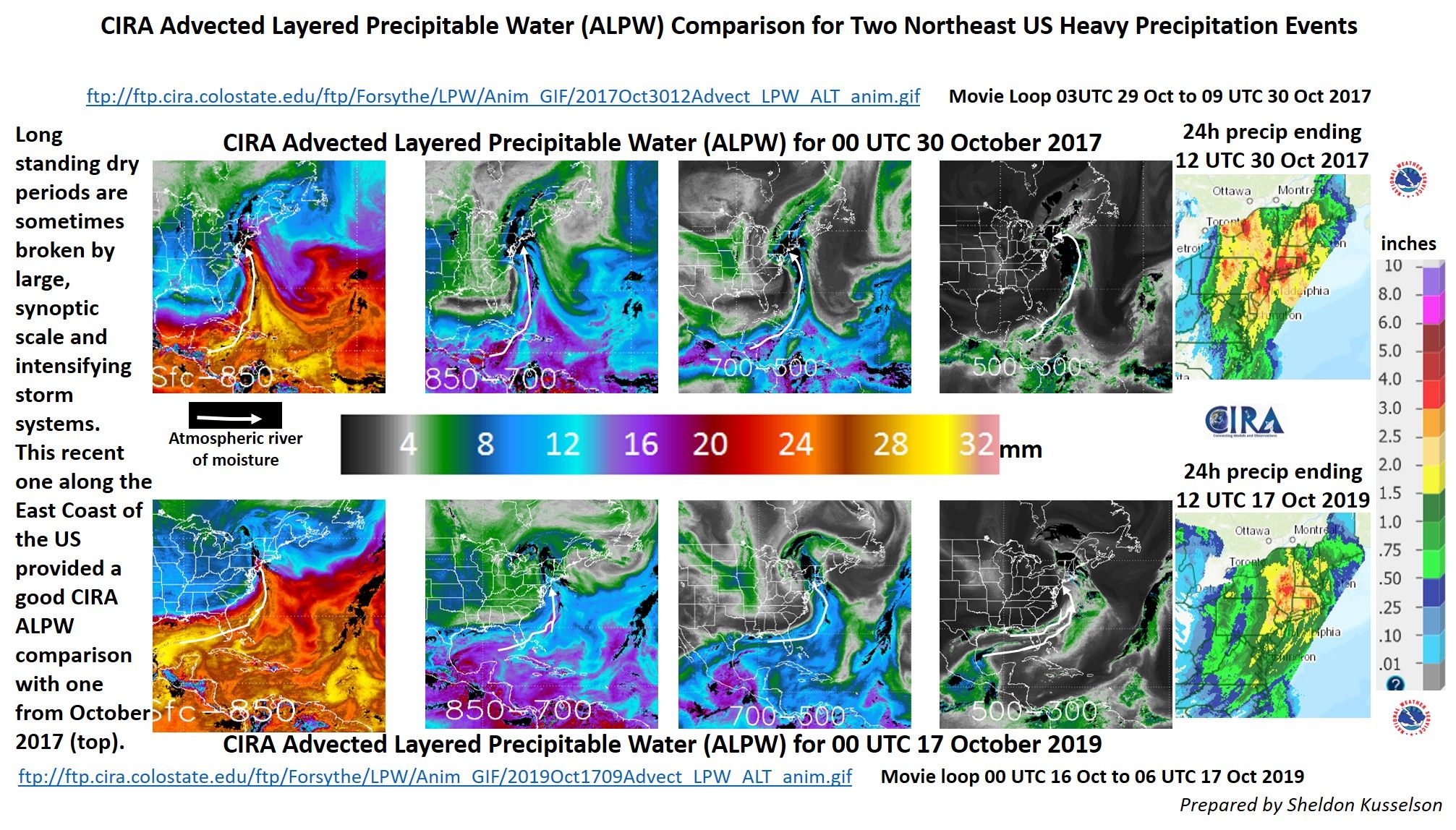
CIRA ALPW Comparison for Two Northeast US Heavy Precipitation Events
October 17th, 2019 by Dan BikosBy Sheldon Kusselson

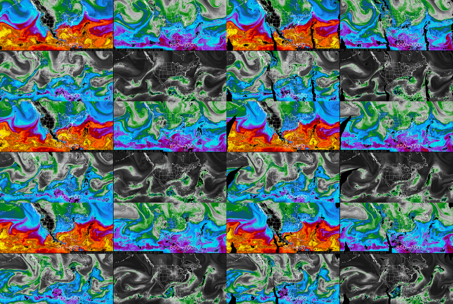
ALPW loop of 2019 event:

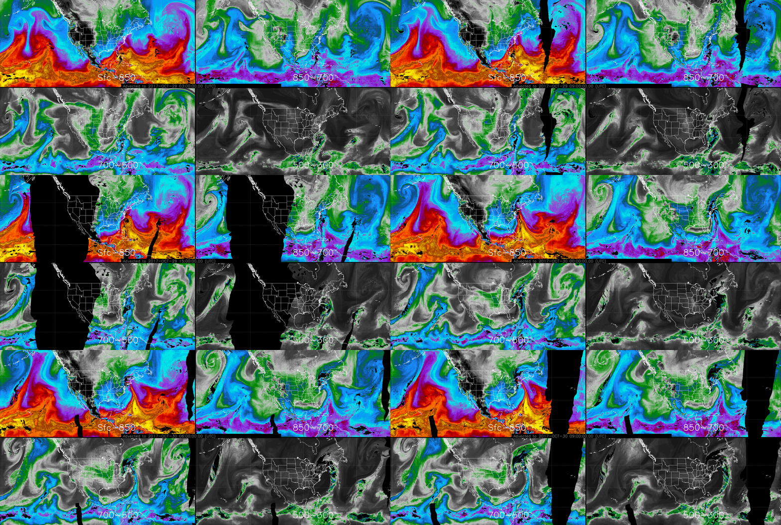
ALPW loop of 2017 event:

Posted in: Coastal Effects, Cyclogenesis, Heavy Rain and Flooding Issues, Hydrology, POES, Satellites, | Comments closed
Subtropical storm Melissa
October 11th, 2019 by Dan BikosBy Sheldon Kusselson and Dan Bikos
Subtropical storm Melissa exists off the Eastern coastline of the U.S. on 10-11 October 2019, as GOES-16 visible imagery on 11 October shows:
note the lack of deep convection over the center of the circulation, however convection does exist north and northeast of the center at this time.
Another perspective on this storm can be seen on the Advected Layer Precipitable Water (ALPW) product:
The ALPW product depicts precipitable water in 4 layers.
Upper left (Surface to 850 mb), Upper right (850 to 700 mb), Lower left (700 to 500 mb), Lower right (500 to 300 mb).
Note the advection of subtropical moisture from two distinct areas in the Atlantic at the two lowest layers and at least one of the two highest layers. Dry areas are probably the blocks to the low off the East Coast.

The storm has brought rainfall from coastal New Jersey to Massachusetts, the moisture associated with this rainfall can also be viewed in a Total Precipitable Water (TPW) product. Here we show the experimental merged TPW product which makes use of observations from both microwave instruments on multiple polar orbiting satellites and the GOES-16 ABI:
Posted in: Heavy Rain and Flooding Issues, Tropical Cyclones, | Comments closed
JPSS/GOES Fire Detection Capabilities – Swan Lake Fire, AK
September 23rd, 2019 by Jorel TorresThe Swan Lake Fire, located in the Kenai National Wildlife Refuge, south of Anchorage, AK initiated in June 2019 due to lightning. Over the past few months, the fire has steadily grown, and as of 20 August 2019, more than 130,000 acres have burned.
To get a close look at the fire refer to the following comparison (see imagery below) at 2248Z, 19 August 2019. Imagery compares SNPP VIIRS 3.7μm to the GOES-17 3.9μm infrared imagery. GOES 3.9μm is at 2-km while the VIIRS 3.7μm is at 375-m spatial resolution. Notice the fine details of the fire areal extent seen by VIIRS, exhibiting warm brightness temperatures (i.e. fire hotspots seen in black). In contrast, the GOES imagery does not capture the intricate fire perimeter, due to its coarser resolution and that it is affected by parallax. Parallax consists of the satellite displacement of features in the imagery, where geostationary observations over northern latitudes are far away from the GOES satellite subpoint (i.e. nadir). The geostationary imagery results in elongated pixels over the fire producing ambiguity in the fire location and perimeter.


Although GOES-17 has a coarser temporal resolution, the animation below highlights the fire at a finer temporal resolution (i.e. 1-minute data) from 2230-2330Z, on 19 August 2019. The visible (0.64μm) and infrared (3.9μm) imagery shows the evolution of the fire location, fire hotspots, and corresponding smoke. Surface observations are overlaid onto the imagery to highlight the air temperature/dewpoint, wind direction and speed, along with smoke and haze identifiers.
[Click animation link] ftp://rammftp.cira.colostate.edu/torres/JPSS_Blog_Swan_Lake_Fire_AK/g17_animation.mp4
To get an idea of the atmospheric environment aloft and near the surface, users can refer to satellite derived NUCAPS soundings that provide temperature and moisture profiles. Remote areas that lack RAOB observations can take advantage of NUCAPS soundings in the operational forecasting environment. The closest NUCAPS profile in proximity to the fire is chosen below (i.e. green dot encompassed by the white circle) at ~23Z, 19 August 2019.

The 23Z NUCAPS and 00Z, 20 August 2019 RAOB sounding from Anchorage, AK are compared below. The NUCAPS and RAOB soundings are ~45 miles apart from each other, where NUCAPS soundings provide a volumetric measurement of the atmosphere and ‘smoothes’ (i.e. averages) the temperature/dewpoint measurements within the profile. In contrast, RAOBs produce measurements along a ‘point’ throughout the atmosphere, producing a finer vertical resolution. Note the RAOB observation provides wind data (surface and aloft), while NUCAPS does not provide wind measurements.
The RAOB sounding observes a weak inversion containing a dry boundary layer and light surface winds, keeping smoke in the lower atmosphere. Precipitable water values are also low in both NUCAPS (0.41 inches) and RAOB (0.53 inches) observations, indicating a relatively dry atmosphere. The NUCAPS profile provides a general idea of what the atmosphere is like, and is sampled closest to the fire in comparison to RAOB (i.e. sounding further away from the fire). However, NUCAPS misses the low-level inversion along with the higher moisture content observed in the mid-levels, noticed by RAOB measurements.


Lastly, one cannot forget the VIIRS Near-Constant Contrast (NCC) product that provides a nighttime visible capability in support of active fires. From the SNPP VIIRS overnight pass at 1235Z, 20 August 2019, the NCC observes the emitted lights produced from the fire, along with the emitted city lights. But how can users decipher between the two features? The images below compare NCC to VIIRS 3.7um to address the question. Note the emitted lights from the fires correspond with the fire hotspots (high brightness temperatures seen in black), where the emitted city lights do not exhibit this correlation. Fire is observed in between Sterling and Cooper Landing, Alaska. Emitted city lights can be seen from Nikiski to Soldtona, AK and up north, near Anchorage, AK.


Posted in: Fire Weather, GOES, POES, Satellites, | Comments closed
VIIRS flood observations along the Arkansas River
June 3rd, 2019 by Jorel TorresHeavy rain fell in Kansas, Oklahoma and Arkansas the past few weeks, causing major flooding along portions of the Arkansas River. In the RealEarth image below (i.e. 1930Z on 27 May 2019), major flooding is indicated in orange and red colors and extends from Fort Gibson in northeast Oklahoma to New Blaine in northwest Arkansas.

In the example above, satellite observations are employed to identify the inundated areas, where the Visible Infrared Imaging Radiometer Suite (VIIRS) Flood Areal Extent is utilized. Product is at 375-m spatial resolution and is available for forecasters via Local Data Manager (LDM).
A VIIRS Flood Areal Extent animation is also provided (see below) from 23-28 May 2019, highlighting the flooding along the Arkansas River. The VIIRS Flood Areal Extent discriminates between different scene types (i.e. MS = missing data (black), LD = land (brown), SI = supra-snow ice (mixed ice and water, or water over ice denoted in purple), SN = snow (white), IC = ice (aqua), Cl = clouds (grey), CS = cloud shadows (dark grey), WA = open water (blue)). The product also calculates the floodwater fraction percentage of a pixel (e.g. the product determines if a pixel is 20%, 40%, 100% flooded). The floodwater fraction percentage is from 0-100% and ranges from green-to-red colors. Notice in the animation, the evolution of the flooding along the Arkansas River and the increased flooding near Fort Smith, AR.
For additional perspective on how much rain accumulated over the area, Advanced Hydrologic Prediction Service (AHPS) 7-day and 14-day observed and normal (i.e. average) precipitation images are shown below at 12Z on 30 May 2019. Observed precipitation is expressed as gridded data with a spatial resolution of 4 kilometers, where precipitation is represented in inches. Notice the high precipitation amounts scattered throughout northeastern Oklahoma and northwest Arkansas over the 7-day and 14-day periods, and how observed precipitation values are significantly higher than their respective 7-day and 14-day normal precipitation values. Maximum 7-day and 14-day observed precipitation reached ~5-6 inches and 10+ inches respectively. The 30-day observed and normal precipitation values (not pictured here) also inferred that soils were saturated, suggesting a conducive environment for flooding as well.
7-Day Observed (left) and Normal (right) Precipitation Values


14-Day Observed (left) and Normal (right) Precipitation Values


More flooding along the Arkansas River is expected throughout the next week, where the latest flooding updates can be accessed via the following National Weather Service (NWS) link.
Posted in: Heavy Rain and Flooding Issues, Hydrology, POES, Satellites, | Comments closed
