NCC monitoring severe weather during the nighttime
April 18th, 2019 by Jorel TorresMonitoring severe weather during the nighttime can be challenging since GOES-16/17 is limited to infrared imagery during the overnight hours. In complement to geostationary data sets, polar-orbiting satellite data can be utilized, specifically the Near-Constant Contrast (NCC) product.
For unfamiliar readers, NCC is a derived product of the Day/Night Band (DNB) that utilizes a sun/moon reflectance model that illuminates atmospheric features and senses emitted (e.g. lights from lightning, fires, city lights) and reflected (e.g. clouds) light sources during the nighttime. The product is considered ‘nighttime visible’ imagery that looks very similar to 0.64μm visible imagery that forecasters use during the daytime. Now NCC also has its limitations, since it is dependent on the lunar phase (i.e. full moon compared to new moon) and moon elevation angle (i.e. the moon position above or below the horizon). NCC imagery can range in texture, varying from ‘crisp and clear’ imagery to ‘fuzzy and non-conspicuous’ imagery depending upon the lunar phase and moon elevation angle. NCC is at 0.7µm, exhibiting a 750-m spatial resolution.
NCC observed severe weather over the southern United States during the early morning hours of 18 April 2019. Severe weather was experienced in several states: Texas, Oklahoma, Arkansas, Louisiana and Mississippi. The NCC and GOES-16 infrared imagery (seen below) observed severe weather in the forms of convective cloud tops (i.e. very cold brightness temperatures), lightning, cloud cover and emitted lights from cities. Imagery is taken at ~0800 UTC on 18 April 2019, where NCC imagery is seen during the full moon phase of the lunar cycle. Notice in the NCC, the lightning that is observed via horizontal white streaks. The white streaks are due to the time discontinuity between the lightning strike (i.e. on the order of milliseconds) and the satellite overpass (i.e. on the order of seconds).
NCC at 0759 UTC, 18 April 2019 – Nighttime Visible Imagery

GOES-16 10.35μm at 0801 UTC, 18 April 2019 – Infrared imagery

The Geostationary Lightning Mapper (GLM) (seen below at the same timestamp) is also used in complement to NCC, in identifying where the high density lightning strikes are observed within the line of storms (red dots); it matches up quite well with NCC. Note, GLM is overlaid onto GOES-16 10.35μm.
GLM at 0801 UTC, 18 April 2019 – Group Flash Counts Density (via CIRA SLIDER)

Posted in: GOES R, Lightning, POES, Satellites, Severe Weather, | Comments closed
High Plains Snowstorm
April 10th, 2019 by Jorel TorresA strong extratropical cyclone moved through the Rocky Mountains and western high plains over the course of 10 April 2019. The low-pressure system produced heavy precipitation in the forms of rain and snow, along with blustery winds.
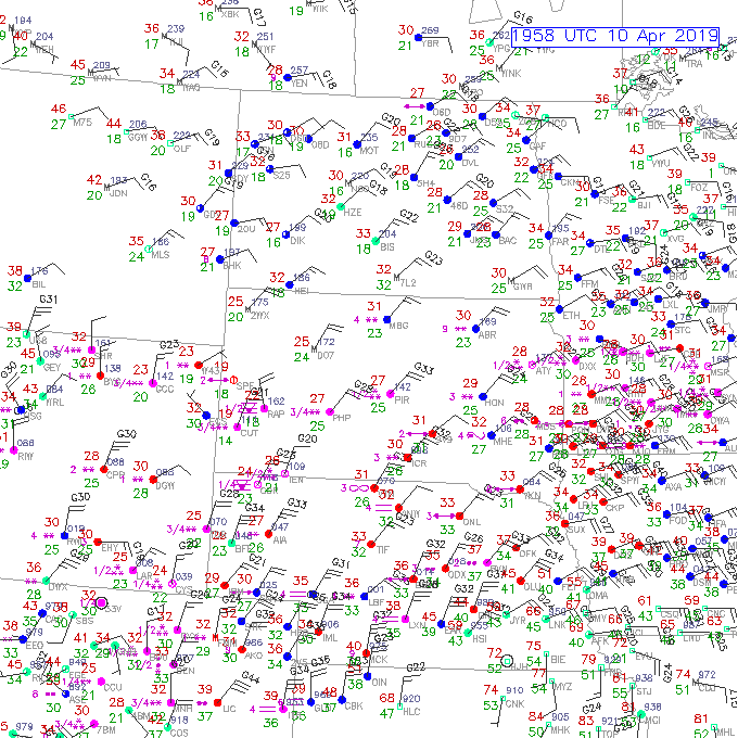
The system produced heavy snow over a large areal extent spanning from Colorado, Wyoming, portions of Nebraska and South Dakota. Below are surface observations captured at ~20 UTC, 10 April 2019. Note the areas of snow designated by pink asterisks, where the increase in the number of asterisks corresponds with the increase in snow intensity. Northerly and northeasterly high winds gusting over 40 mph were observed as well.
Surface Observations – at 1958 UTC, 10 April 2019
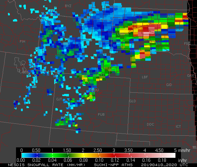
In complement to the surface observations are microwave observations from polar-orbiting satellites, notably, in the form of the Blended Snowfall Rate (SFR) product exhibiting a liquid equivalent snowfall rate. Image below is a static SFR product from the Advanced Technology Microwave Sounder (ATMS) instrument on-board the Suomi-National Polar-orbiting Partnership (S-NPP) satellite. Note high liquid equivalent snowfall rates are observed in north-central Colorado, southeast Wyoming, north-central Nebraska and South Dakota, where heavy snowfall rates in South Dakota ranged from 1.5-4 mm/hr or 0.06-0.16 inches/hr. Another benefit of SFR is the product can observe snowfall rates over large domains, where in comparison to radar, radar coverage can be limited due to data gaps or beam blockages.
S-NPP ATMS -Liquid equivalent snowfall rate at 2020 UTC, 10 April 2019.
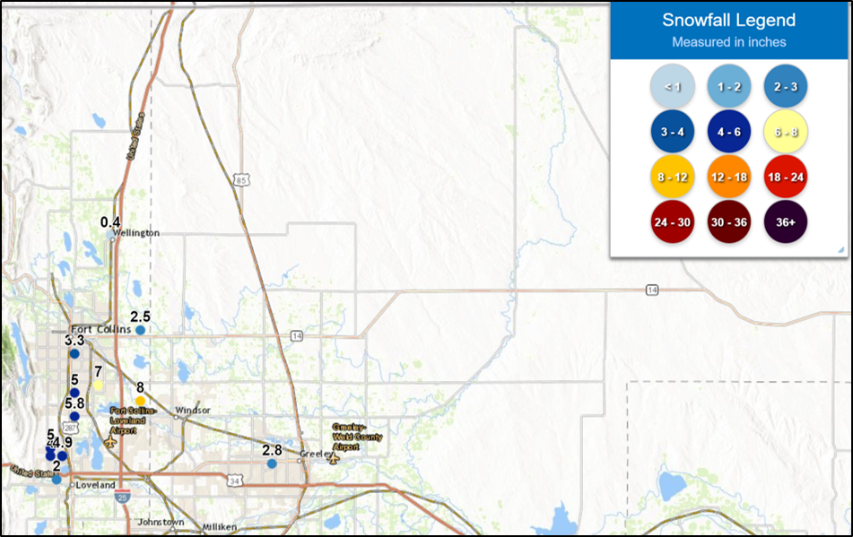
In the following two images, notice the National Weather Service (NWS) ‘preliminary’ high snow totals observed over western South Dakota and north-central Colorado are located over the same domains as the high snowfall rates observed by the SFR product.
NWS Preliminary Snow Totals as of o1oo UTC, 11 April 2019 over Western South Dakota

NWS Preliminary Snow Totals as of o1oo UTC, 11 April 2019 over the Front Range of Colorado
Posted in: POES, Satellites, Winter Weather, | Comments closed
2-3 April 2019 East Coast Low – ALPW analysis
April 9th, 2019 by Dan Bikos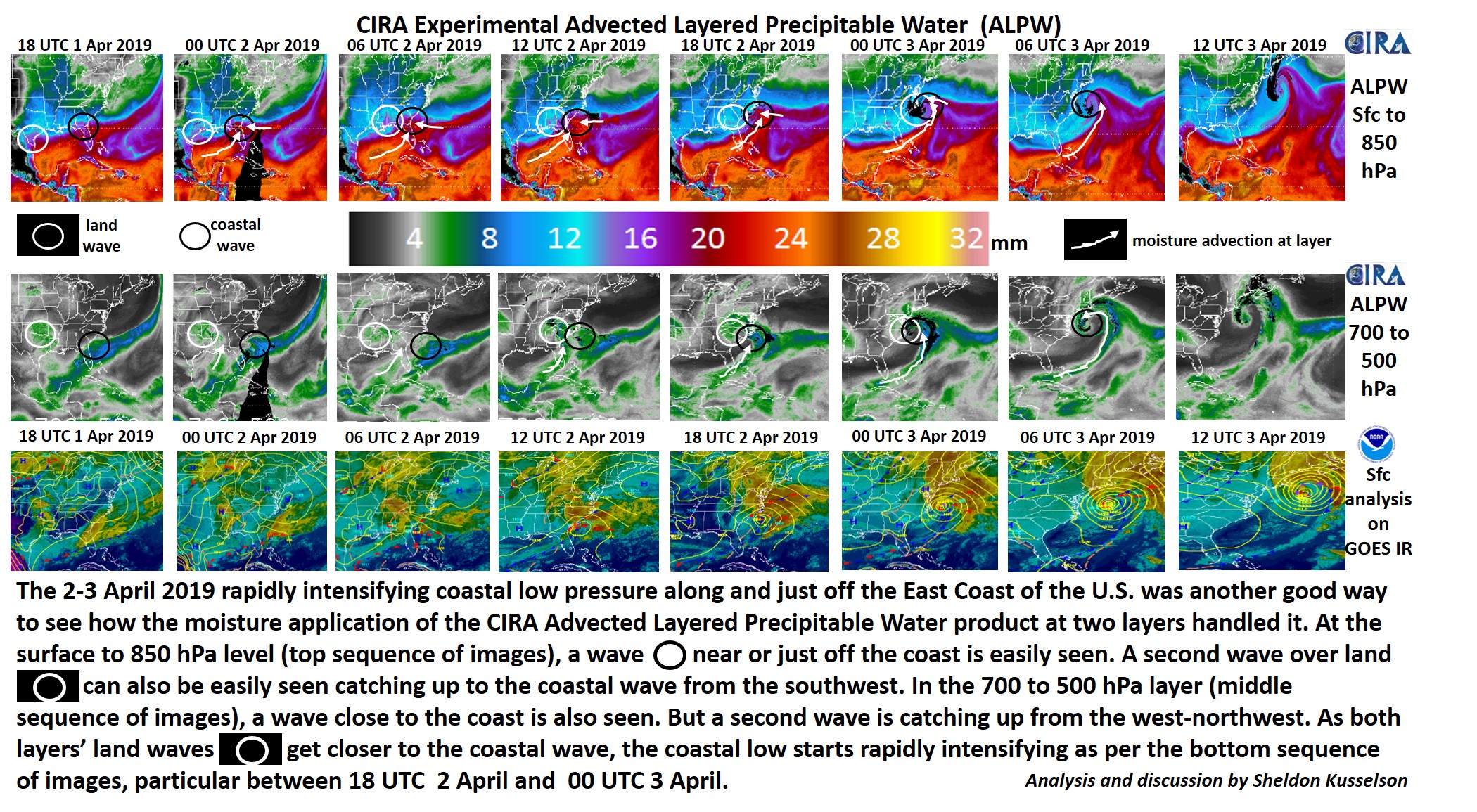
Posted in: POES, | Comments closed
Nebraska flooding
March 22nd, 2019 by Jorel TorresThe past two weeks Nebraska has been inundated with heavy precipitation, in the forms of rain and snow. Nebraska was significantly affected by the ‘record-breaking’ mid-latitude cyclone that past through the area from 13-15 March 2019. Refer to the GOES-16 10.3um infrared satellite imagery below, seen from 5Z, 13 March 2019 to 22Z, 14 March 2019. Throughout the animation, notice the large areal extent of the cyclone and the cold convective cloud tops (i.e. cold brightness temperatures) indicating varying levels of precipitation in Eastern Nebraska.
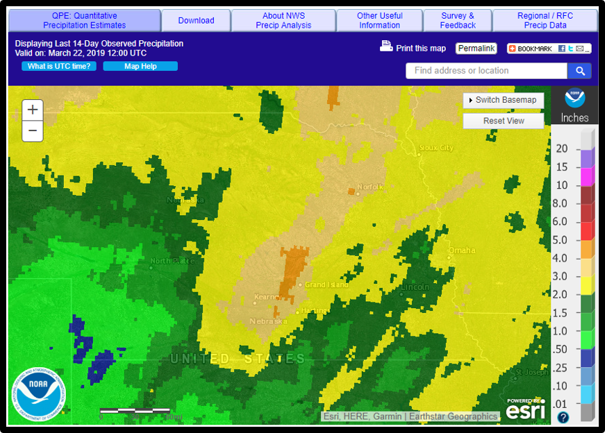
From this storm, plus subsequent storms thereafter, extreme flooding has transpired throughout eastern Nebraska. The image below displays the observed precipitation values over Nebraska the last 14 days, valid at 12Z, 22 March 2019. Product is provided from the National Weather Service (NWS) – Advanced Hydrologic Prediction Services (AHPS). Precipitation values ranged from 1-5 inches throughout Nebraska.
Coinciding with the precipitation values is polar-orbiting satellite data that observes the magnitude of flooding via Suomi-National Polar-orbiting Partnership (S-NPP) Visible Infrared Imaging Radiometer Suite (VIIRS) Flood Areal Extent product. The product (seen in animation below) shows the areas of flooding (i.e. yellow, orange, red colors) in Eastern Nebraska and Iowa between 15-21 March 2019. 17 and 19 March were omitted due to cloud obscuration observed over the area. VIIRS Flood Areal Extent calculates the floodwater fraction percentage of a pixel (i.e. from 0-100%, green-to-red colors), and discriminates between different scene types. Note in the legend: LD = land (brown), SI = supra/snow ice (mixed water and ice, or water over ice, seen in purple), IC = ice (river or lake ice, seen in aqua), CL = clouds (grey), CS = cloud shadows (dark grey), and WA = open water (blue). Spatial resolution of the product is at 375-m resolution. Within the animation, see the evolution of the floodwaters as they increase in width or move along the rivers.
Posted in: GOES, Heavy Rain and Flooding Issues, Hydrology, POES, Satellites, | Comments closed
Polar orbiting and geostationary lake ice monitoring
March 10th, 2019 by Jorel TorresMonitoring lake ice coverage over the Great Lakes via satellite is vital and affects shipping industries, tourism and recreation, especially over the winter months when ice develops, grows and expands over the lakes. According to the Great Lakes Surface Environmental Analysis (GLSEA) and NOAA CoastWatch, the total ice coverage between all 5 lakes is 80% as of 8 March 2019. GLSEA and NOAA CoastWatch’s diagram below highlights lake ice coverage (i.e. ice depicted as grey, dark grey and black colors) and the areas of open water seen via different shades of blue (i.e. represented via water temperatures, ~0°C-5°C).

Satellite observations, combined with other data sets, are vital in producing ice coverage percentages over the Great Lakes. On 8 March 2019, under moderate clear-sky conditions, polar-orbiting and geostationary satellites observe the Great Lakes at high spatial resolution. Note, geostationary observations express high temporal resolution as well, however polar-orbiting observations exhibit coarser temporal resolution. Satellite imagery and products are shown below and are provided from RAMSDIS Online, CIRA SLIDER and RealEarth.
S-NPP Day/Night Band (DNB) – Solar Reflectance (0.7um) at 1850Z, 8 March 2019
DNB solar reflectance acts like ‘daytime visible imagery’ (i.e. 0.64um) where DNB’s satellite sensor observes the solar reflectance from atmospheric or surface features that exhibit high albedos. DNB provides imagery (below) at 750-m resolution and shows open water, land, ice and clouds, above and around the Great Lakes. However, how can users differentiate between the aforementioned scene types?

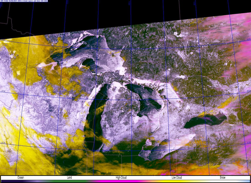
S-NPP VIIRS Snow/Cloud Layers at 1850Z, 8 March 2019
Look no further than to the polar-orbiting VIIRS Snow/Cloud Layers product which is at 750-m resolution. Observing the same domain as DNB, the VIIRS Snow/Cloud Layers differentiates between land (green), snow and ice (white), low (yellow) and high (pink) clouds and bodies of water (dark blue/black).
GOES-16 Snow/Cloud Layers from 1832-1927Z, 8 March 2019
Now incorporate a similar product, except derived from the geostationary satellite, GOES-16, users can observe the Great Lakes at high temporal resolution. Temporal resolution is from the CONUS sector, that is, 5-minute geostationary data. Notice the lake ice movement (i.e. moving white features over the Great Lakes) along with the low and high clouds moving to the east. Lake ice motion can be seen more conspicuously over Lake Huron.
S-NPP VIIRS Flood Detection Product at 1900Z, 8 March 2019
Additionally, another polar-orbiting product that users can observe the Great Lakes and differentiate between surface and atmospheric features, is the VIIRS Flood Detection product. Product is at 375-m resolution, discriminates between different scene types: ice = aqua, supra-snow ice (water on top of ice, or melting ice) = purple, open water = blue, clouds = grey, snow = white, and land = brown. The product also calculates the floodwater fraction percentage from 0-100% (green-red colors) as well. VIIRS Flood product can be accessed in AWIPS-II via LDM.

Posted in: POES, | Comments closed
