
Max Road Miramar Fire, Florida
Over the weekend the Max Road Miramar Fire initiated and burned ~11,400 acres across south Florida. As of 13 May 2026, ~95% of the brush fire was contained, per Watch Duty. Local media outlets covered the event as the fire spread unnervingly close to homes and infrastructure along the western side of the Miami metropolitan area.
The GOES-19 ABI GeoFire product captured the hotspots in red, orange, yellow, and white pixels indicating warm, very warm, hot, and intense fires respectively. A 15 hour product animation is shown below, that observes the increasing fire intensity and spread to the west/northwest. GeoFire has the ability to observe fire hotspots during the day and night, while also observing the daytime smoke that is moving to the east and seen across the metro area.
GeoFire observations from 15Z, 10 May 2026 to 06Z, 11 May 2026
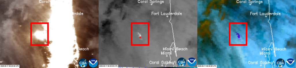
The VIIRS instrument on-board polar-orbiting satellites observed the fire at night at 750-m resolution. In the VIIRS 3-panel imagery comparison below, a red box encapsulates where the Max Road Miramar Fire is located. The VIIRS GeoColor (left) incorporates near-real-time Day/Night Band (DNB) data at night, where it shows the emitted lights produced from the fire, along with the nearby emitted city lights. The VIIRS (M12) 3.7 um (center) and the VIIRS NGFS Microphysics RGB (right) depict the thermal hotspots in white/red pixels in the shortwave infrared and purple pixels in the RGB. Within the red box, the fire hotspots correspond with a subset of emitted lights, indicating that these lights are produced from the fire. Note, lights that do not have a corresponding thermal signature can be inferred as emitted city lights.
VIIRS 3-Panel [GeoColor, M12 – 3.7 um, NGFS Microphysics RGB] at 0620Z, 11 May 2026
The VIIRS Active Fires product also captured the Max Road Miramar Fire, where it displayed numerous fire points in yellow, orange, and red colors that indicate an increasing fire intensity (a.k.a., Fire Radiative Power, expressed in MegaWatts, MW). A sample pixel readout of the product can be seen on 10 May 2026, where the red pixel observed a higher fire intensity of ~179 MW.
NOAA-21 VIIRS Active Fires at 1758Z, 10 May 2026

At the time of this blog entry, no infrastructures were impacted by this brush fire.