
GOES-15 NOAA/SciencePost Launch Test (PLT)
| (Last updated: 2011-12-08) |
GOES-15 became the operational GOES-West on 6 December 2011, when GOES-15 replaced GOES-11. More information can be found at: http://www.noaanews.noaa.gov/stories2011/20111206_goessatellite.html and http://cimss.ssec.wisc.edu/goes/blog/archives/9307
| With the GOES-15 Science Test now complete, Don Hillger and Tim Schmit would like to thank those who helped coordinate the test schedules, as well as those who collected and analyzed GOES-15 data. NOAA_Technical Report 141: GOES-15 Science Test is available for downloading (6.3 MB, final version, 2011-12-07). The report will be available on CD as well. A copy of the CD will be sent to anyone who requests one. (Send e-mail requests to the address at the bottom of this page.)Hillger, D.W., and T.J. Schmit, 2011: Imager and Sounder Radiance and Product Validation for the GOES-15 Science Test, NOAA Technical Report, NESDIS 141, (November), 101 pp. |
The previous GOES-14 Science Test was conducted in December 2009. See the GOES-14 Science Test for information and the completed NOAA Technical Report about GOES-14.
GOES-15 Science Test Schedules
and
Daily Implementation
Reverse Chronology of GOES-15 Significant Events
GOES-15 Reference Information/Websites
GOES-15 Science Test Schedules
The test schedule changes daily at 1630 UTC and runs for 24 hours, unless otherwise noted. On weekends the schedules for Saturday and Sunday were determined on Friday.
| Test Schedule Name | Imager | Sounder | Purpose |
|---|---|---|---|
| C1CON | Continuous 5-minute CONUS sector | 26-minute CONUS sector every 30 minutes | Test navigation, ABI-like (temporal) CONUS scans |
| C2SRSO | Continuous 1-minute rapid-scan (with center point specified for storm analysis) | 26-minute CONUS sector every 30 minutes | Test navigation, ABI-like (temporal) mesoscale scans |
| C3SRSO | Continuous 30-second rapid-scan (with center point specified for storm analysis) | 26-minute CONUS sector every 30 minutes | Coordination with lightning detection arrays in Huntsville AL, Norman OK, and Washington DC areas1 |
| C4RTN2 | Emulation of GOES-West routine operations | Emulation of GOES-West routine operations | Radiance and product comparisons |
| C5RTN2 | Emulation of GOES-East routine operations | Emulation of GOES-East routine operations | Radiance and product comparisons |
| C6FD | Continuous 30-minute Full Disk (including off-earth measurements) | Sectors on both east and west limbs every hour (including off-earth measurements)3 | Imagery for noise, striping, etc. |
| C7MOON (depends on moon availability)4 | Capture moon off edge of earth (when possible) for calibration purposes | Inserted into current schedule | Test ABI lunar calibration concepts |
| C8HUR | Continuous 5-minute CONUS-size hurricane sector | Emulation of GOES-East routine operations | Hurricane monitoring for tropical cyclone field experiments5 |
1Including the Hazardous Weather Testbed in North Alabama (centered at Huntsville AL, 34.72°N 86.65°W), the Oklahoma Lightning Mapping Array (centered at Norman OK, 35.28°N 97.92°W), and the Washington DC lightning mapping array (centered over Falls Church VA, 38.89°N 77.17°W).
2During C4RTN and C5RTN schedules, special stray light test sectors for both the Imager and Sounder were taken between 0400 and 0800 UTC starting 23 August 2010 [Julian Day 235].
3Limb sectors similar to GOES Sounder scans during previous GOES Science Tests.
4Successive images of the moon were captured on 26 April (see below), 30 July (see below), and 27 August (see below).
5In un-official support of two large field campaigns (NASA GRIP and NSF PREDICT).
Daily Implementation of GOES-15 Science Test Schedules
(Daily starting time: 1630 UTC, unless otherwise noted)
| Starting Date [Julian Day] (Day of Week) | Test Schedule Name | Imager | Sounder | Purpose |
|---|---|---|---|---|
| Start of 6-week Science Test | ||||
| August 11 [223] (Wednesday) | C1CON | Continuous 5-minute CONUS sector | 26-minute CONUS sector every 30 minutes | ABI-like (temporal) CONUS scans |
| August 12 [224] (Thursday) | C1CON | Continuous 5-minute CONUS sector | 26-minute CONUS sector every 30 minutes | ABI-like (temporal) CONUS scans |
| August 13 [225] (Friday) | C1CON | Continuous 5-minute CONUS sector | 26-minute CONUS sector every 30 minutes | ABI-like (temporal) CONUS scans |
| August 14 [226] (Saturday) | C5RTN | Emulation of GOES-East routine operations | Emulation of GOES-East routine operations | Radiance and product comparisons |
| August 15 [227] (Sunday) | C5RTN | Emulation of GOES-East routine operations | Emulation of GOES-East routine operations | Radiance and product comparisons |
| August 16 [228] (Monday) | C1CON | Continuous 5-minute CONUS sector | 26-minute CONUS sector every 30 minutes | ABI-like (temporal) CONUS scans |
| August 17 [229] (Tuesday) | C1CON | Continuous 5-minute CONUS sector | 26-minute CONUS sector every 30 minutes | ABI-like (temporal) CONUS scans |
| August 18 [230] (Wednesday) | C5RTN | Emulation of GOES-East routine operations | Emulation of GOES-East routine operations | Radiance and product comparisons |
| August 19 [231] (Thursday) | C5RTN | Emulation of GOES-East routine operations | Emulation of GOES-East routine operations | Radiance and product comparisons |
| August 20 [232] (Friday) | C5RTN | Emulation of GOES-East routine operations | Emulation of GOES-East routine operations | Radiance and product comparisons |
| August 21 [233] (Saturday) | C6FD | Continuous 30-minute Full Disk | Sectors on both east and west limbs every hour | Imagery for noise, striping, etc. |
| August 22 [234] (Sunday) | C6FD | Continuous 30-minute Full Disk | Sectors on both east and west limbs every hour | Imagery for noise, striping, etc. |
| August 23 [235] (Monday) | C8HUR | Continuous 5-minute CONUS-size hurricane sector | Emulation of GOES-East routine operations | Hurricane monitoring |
| August 24 [236] (Tuesday) starting 0900 UTC | C2SRSO1 | Continuous 1-minute rapid-scan (center point 18°N, 46°W) | 26-minute CONUS sector every 30 minutes | Hurricane (Danielle) monitoring |
| August 24 [236] (Tuesday) starting 2100 UTC | C8HUR | Continuous 5-minute CONUS-size hurricane sector | Emulation of GOES-East routine operations | Hurricane monitoring |
| August 25 [237] (Wednesday) | C4RTN | Emulation of GOES-West routine operations | Emulation of GOES-West routine operations | Radiance and product comparisons |
| August 26 [238] (Thursday) | C4RTN | Emulation of GOES-West routine operations | Emulation of GOES-West routine operations | Radiance and product comparisons |
| August 27 [239] (Friday) | C4RTN | Emulation of GOES-West routine operations | Emulation of GOES-West routine operations | Radiance and product comparisons |
| August 27 [239] (Friday) ~1900 to ~2045 UTC | C7MOON | Capture moon off edge of earth | Inserted into current schedule | Test ABI lunar calibration concepts |
| August 28 [240] (Saturday) | C8HUR2 | Continuous 5-minute CONUS-size hurricane sector | Emulation of GOES-East routine operations | Hurricane monitoring |
| August 29 [241] (Sunday) | C8HUR | Continuous 5-minute CONUS-size hurricane sector | Emulation of GOES-East routine operations | Hurricane monitoring |
| August 30 [242] (Monday) | C8HUR | Continuous 5-minute CONUS-size hurricane sector | Emulation of GOES-East routine operations | Hurricane monitoring |
| August 31 [243] (Tuesday) ~1715 to ~2130 UTC [Day 244] | Yaw Flip Maneuver | Not specified | Not specified | Due to yaw flip, no Science Test schedule available |
| September 1 [244] (Wednesday) starting ~2230 UTC | C8HUR | Continuous 5-minute CONUS-size hurricane sector | Emulation of GOES-East routine operations | Hurricane (Earl) monitoring |
| September 2 [245] (Thursday) | C1CON | Continuous 5-minute CONUS sector | 26-minute CONUS sector every 30 minutes | ABI-like (temporal) CONUS scans, including Hurricane (Earl) monitoring |
| September 3 [246] (Friday) 0945 UTC to ~0045 UTC [Day 247] | C2SRSO | Continuous 1-minute rapid-scan (center point 39°N, 72°W) | 26-minute CONUS sector every 30 minutes | Hurricane (Earl) monitoring |
| September 4 [247] (Saturday) starting 0045 UTC | C6FD | Continuous 30-minute Full Disk | Sectors on both east and west limbs every hour | Imagery for noise, striping, etc. |
| September 5 [248] (Sunday) starting 0045 UTC | C6FD | Continuous 30-minute Full Disk | Sectors on both east and west limbs every hour | Imagery for noise, striping, etc. |
| September 6 [249] (Monday) starting 0045 UTC | C5RTN | Emulation of GOES-East routine operations | Emulation of GOES-East routine operations | Radiance and product comparisons |
| September 7 [250] (Tuesday) | C1CON | Continuous 5-minute CONUS sector | 26-minute CONUS sector every 30 minutes | ABI-like (temporal) CONUS scans |
| September 8 [251] (Wednesday) | C5RTN | Emulation of GOES-East routine operations | Emulation of GOES-East routine operations | Radiance and product comparisons |
| September 9 [252] (Thursday) | C5RTN | Emulation of GOES-East routine operations | Emulation of GOES-East routine operations | Radiance and product comparisons |
| September 10 [253] (Friday) | C5RTN | Emulation of GOES-East routine operations | Emulation of GOES-East routine operations | Radiance and product comparisons |
| September 11 [254] (Saturday) | C2SRSO | Continuous 1-minute rapid-scan (center point 35°N, 87°W) | 26-minute CONUS sector every 30 minutes | Huntsville AL lightning mapping array |
| September 12 [255] (Sunday) | C5RTNS | Emulation of GOES-East routine operations | Emulation of GOES-East routine operations | Special Sounder sectors for striping analysis/abatement |
| September 13 [256] (Monday) | C2SRSO | Continuous 1-minute rapid-scan (center point 18°N, 51°W) | 26-minute CONUS sector every 30 minutes | Hurricane (Igor) monitoring |
| September 13 [256] (Monday) starting 2200 UTC | C8HUR | Continuous 5-minute CONUS-size hurricane sector | Emulation of GOES-East routine operations | Hurricane (Igor) monitoring |
| September 14 [257] (Tuesday) | C8HUR | Continuous 5-minute CONUS-size hurricane sector | Emulation of GOES-East routine operations | Hurricane monitoring |
| September 15 [258] (Wednesday) | C8HUR | Continuous 5-minute CONUS-size hurricane sector | Emulation of GOES-East routine operations | Hurricane monitoring |
| September 16 [259] (Thursday) | C8HUR | Continuous 5-minute CONUS-size hurricane sector | Emulation of GOES-East routine operations | Hurricane monitoring |
| September 17 [260] (Friday) 1145 UTC to ~0045 UTC [Day 261] | C2SRSO3 | Continuous 1-minute rapid-scan (center point 20°N, 96°W) | 26-minute CONUS sector every 30 minutes | Hurricane (Karl) monitoring |
| September 18 [261] (Saturday) starting 0045 UTC | C8HUR | Continuous 5-minute CONUS-size hurricane sector | Emulation of GOES-East routine operations | Hurricane monitoring |
| September 19 [262] (Sunday) | C8HUR | Continuous 5-minute CONUS-size hurricane sector | Emulation of GOES-East routine operations | Hurricane monitoring |
| September 20 [263] (Monday) | C2SRSO | Continuous 1-minute rapid-scan (center point 39°N, 114°W) | 26-minute CONUS sector every 30 minutes | Western fires and fog burnoff |
| September 21 [264] (Tuesday) starting 1245 UTC | C2SRSO | Continuous 1-minute rapid-scan (center point 41°N, 90°W) | 26-minute CONUS sector every 30 minutes | Potential severe weather |
| End of 6-week Science Test | ||||
| Starting September 22 [265] (Wednesday) | GOES-15 continued to operate through 24/25 October 2010 [Day 297/298], but with only two schedule options, either C5RTN, or a C5RTN schedule with occasional hurricane sectors. At that point the Imager and Sounder were put into storage mode. | |||
| September 23 and 24 [266 and 267] (Thursday and Friday) ~1900 to ~2045 UTC? | C7MOON | Capture moon off edge of earth | Inserted into current schedule | Test ABI lunar calibration concepts |
1There is a gap in the intended C2SRSO collection, between ~1445 and ~1839 UTC [Day 236].
2There is a large gap in the intended C8HUR collection, between ~1622 and ~0245 UTC [Day 241].
3There is a delay in the start of the C2SRSO collection, from ~1145 to ~1415 UTC [Day 260].
Reverse Chronology of GOES-15 Significant Events:
The following sections are presented in reverse chronological order, with the newest information at the top. Older information may be outdated or superseded.
2011 September 07:
For presentations prepared for the GOES-15 Readiness Review and about the Science Test see:
ftp://ftp.ssec.wisc.edu/ABI/goes15/GOES-15_Schmit_readiness_review.ppt
and:
ftp://ftp.ssec.wisc.edu/ABI/goes15/GOES-15_Science_Test_soc_update.pptx
2010 November 15:
At the request of the OSPO (Office of Satellite Products and Operations), presentations were given by D. Hillger and T. Schmit on the GOES-14 Science Test. The presentations covered the test overview, radiance comparisons, and product validations. A third presentation was given by Hyre Bysal on GOES-15 Sounder Open GOES Incident Reports. Below are links to the individual presentations:
- GOES-14_Science_Test_Plan_Don Hillger.pptx
- GOES-14_Tim_Schmit_08Nov2010.ppt
- G-15 Sounder GIRs 11.3.2010.ppt
2010 September 21:
An example to prove that 1-minute interval imagery can be a significant improvement over the “standard” 15-minute interval imaqery in terms of monitoring the temporal variability of small and short-lived agricultural fires over the southern Mississippi River Valley region. See the CIMSS Blog entry at http://cimss.ssec.wisc.edu/goes/blog/archives/6849. (Courtesy of Scott Bachmeier, CIMSS)
GOES-15 SRSO visible images showing some nice structure and evolution of the stratus clouds along and just offshore of the coast of southern California on 20 September are available at http://cimss.ssec.wisc.edu/goes/blog/archives/6835. (Courtesy of Scott Bachmeier, CIMSS)
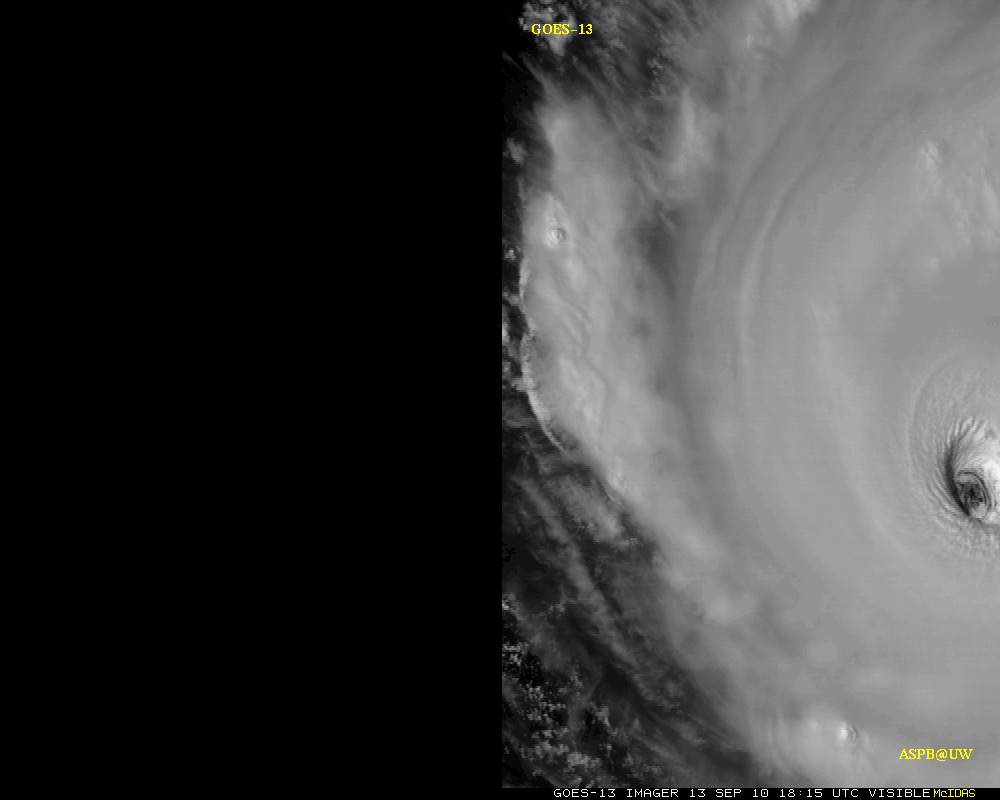
2010 September 17:
GOES-13 versus GOES-15 high-time resolution loops of Hurricane Igor
(Note that these images have been digitally stretched.)
- GOES-13 vs GOES-15 visible loop (http://cimss.ssec.wisc.edu/goes/abi/loops/Igor_zoom_goes_15_13.gif) (animated GIF)
- GOES-13 only (http://cimss.ssec.wisc.edu/goes/abi/loops/Igor_zoom_goes_13_only.gif) (animated GIF)
- GOES-13 vs GOES-15 -less magnification (http://cimss.ssec.wisc.edu/goes/abi/loops/Igor_goes_15_13_aspb.gif) (animated GIF)
Images provided by CIMSS (http://cimss.ssec.wisc.edu/goes/abi/)
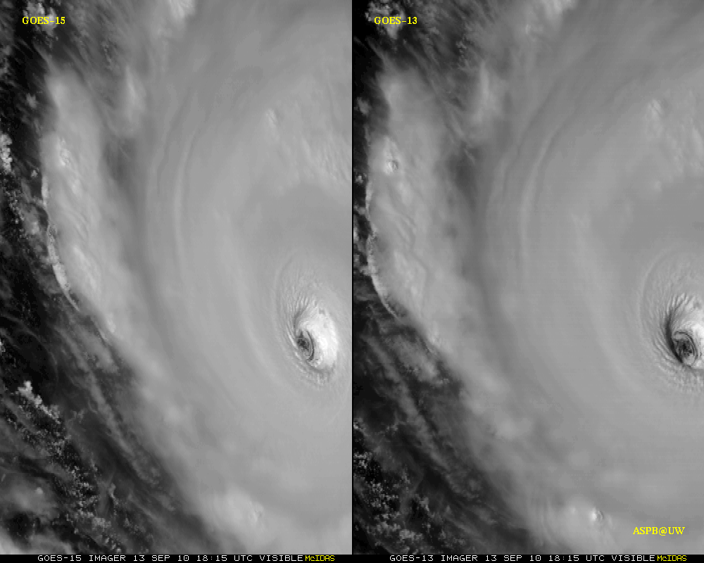
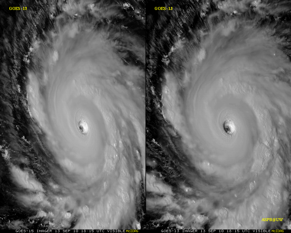
2010 September 14:
Hurricane Igor:


GOES-15 visible and IR images of Hurricane Igor at 1915 UTC on 13 September 2010.

GOES-15 1-minute RSO visible image loop of Hurricane Igor. See http://cimss.ssec.wisc.edu/goes/blog/archives/6790. (Courtesy of Scott Bachmeier, CIMSS)
2010 September 02:
Hurricane Earl:

GOES-15 1-minute RSO visible image loop of Hurricane Earl. See http://tinyurl.com/23xwfq8. (Courtesy of Scott Bachmeier, CIMSS)
2010 September 01:
The turnover of GOES-15 from NASA to NOAA was covered in the following press releases:
- NASA: “NASA and NOAA’s Newest GOES Satellite Ready for Action”: http://www.nasa.gov/mission_pages/GOES-P/news/goes-p-ready.html
- NOAA: “NASA, NOAA: Newest GOES Satellite Ready For Action”: http://www.noaanews.noaa.gov/stories2010/20100901_goes15.html
2010 August 30:
Hurricane Earl:


GOES-15 0.63 µm visible images and 10.7 µm IR images showed two distinct convective bursts that were developing within the CDO region (the 15 UTC and 18 UTC positions of the center of Earl are marked on the images). The coldest cloud top IR brightness temperatures were -86ºC (darker violet color enhancement) at 16:15 UTC and again at 19:25 UTC. The far eastern portion of the island of Guadeloupe can be seen mapped in dark blue along the lower left edge of the GOES-15 images.
See also the CIMSS Satellite Blog at http://cimss.ssec.wisc.edu/goes/blog/archives/6524. (Courtesy of Scott Bachmeier, CIMSS)
2010 August 27:

(Abvove) One of a third sequence of twenty-seven GOES-15 images of the moon that were captured for lunar calibration purposes. (Courtesy of Gordana Rancic and Jerry Cantril)
2010 August 24:
Rapid scan imagery for Tropical Storm Danielle:


1-minute rapid scan imagery was collected over Tropical Storm/Hurricane Danielle on 23 August 2010, with the sector centered at 18°N and 46°W. Image loops of the GOES-15 visible and IR window bands are available in the following links. (Courtesy of Dan Lindsey, RAMMB/CIRA)
- http://rammb.cira.colostate.edu/ramsdis/online/loop_srso.asp?data_folder=goes-r_proving_ground/g15_srso_vis&width=600&height=600
- http://rammb.cira.colostate.edu/ramsdis/online/loop_srso.asp?data_folder=goes-r_proving_ground/g15_srso_ir&width=600&height=600
See also the CIMSS Satellite Blog at http://cimss.ssec.wisc.edu/goes/blog/archives/6441. (Courtesy of Scott Bachmeier, CIMSS)
2010 August 23:
Unusually dry water vapor image signature over the central U.S.:

McIDAS images of GOES-15 6.5 µm “water vapor channel” data showed a series of these 30-minute interval full disk images during a 24-hour period during 21 August – 22 August 2010. It should be pointed out that the ABI instrument on the GOES-R satellite will provide a full disk image every 5 minutes! Note that some of warmest water vapor brightness temperatures (yellow to orange color enhancement) — which normally indicate areas of very dry air in the middle to upper troposphere — were found over the central U.S. during this particular period. (Courtesy of Scott Bachmeier, CIMSS)
2010 August 19:
Severe thunderstorm in southern Arizona:

An isolated thunderstorm over southwestern Arizona during the afternoon hours on 17 August 2010 was responsible for a report of surface winds of 76 knots (91 mph) along with 0.80 inch of rain in 45 minutes near Ajo (SPC storm reports). McIDAS images of 1-km resolution GOES-15 0.63 µm visible channel data (above) showed the rapid development of this thunderstorm (along with several other storms across Arizona) — the time and location of the surface wind gust is annotated as “G76” on the 2030 UTC image. (Courtesy of Scott Bachmeier, CIMSS)
2010 August 17:
Wildfires in British Columbia, Canada:

Unusually hot and dry mid-August conditions beneath a strong ridge of high pressure across British Columbia led to a a major outbreak of wildfires across that western Canadian province — 1-km resolution GOES-15 0.63 µm visible channel images (above) showed the development of a number of large and very dense smoke plumes late in the day on 14 August 2010. A veil of smoke aloft from the previous day of fire activity could also be seen drifting southwestward across the adjacent offshore waters of the Pacific Ocean. See the CIMSS Satellite Blog at http://cimss.ssec.wisc.edu/goes/blog/archives/6366 (Courtesy of Scott Bachmeier, CIMSS)

A weak, isolated tornado developed in southwestern Minnesota during the afternoon of 11 August 2010. GOES-15 imagery, above, shows the development of modest cumulus convection that spawned the tornado. The 5-minute time-step in the imagery is similar to that that will be available routinely from the ABI on GOES-R. See the CIMSS Satellite Blog at http://cimss.ssec.wisc.edu/goes/blog/archives/6346 (Courtesy of Scott Bachmeier, CIMSS)
2010 August 09:
Convection over southeast U.S.:

These stereoscopic views of diurnal convection over the southeast U.S., one from GOES-13 and the other from GOES-15, are one of a number of recent GOES-15 entries to the CIMSS satellite blog http://cimss.ssec.wisc.edu/goes/blog/archives/category/goes-15. (Courtesy of Scott Bachmeier, CIMSS)
2010 July 30:
A second moon-capture sequence:

Another sequence of fourteen 4 km GOES-15 images of the moon as it passed behind the Earth at very low latitudes. (Courtesy of Gordana Rancic and Jerry Cantril)
2010 April 26:
First official full-disk infrared images from GOES-15


The first two full-disk infrared images from GOES-15 were sent down in GVAR format at 1730 and 1800 UTC. The above animations show the two images.
A larger version of the first GOES-15 full-disk infrared image. (Courtesy of UW/CIMSS)

The first GOES-15 infrared images were also captured at CIMSS/ASPB and are seen in the multi-panel display above.
Additional GOES-15 images have been posted as part of the CIMSS Satellite Blog http://cimss.ssec.wisc.edu/goes/blog/archives/5353 (Courtesy of Scott Bachmeier, CIMSS)
See also the CIMSS GOES-15 Spotlight http://www.ssec.wisc.edu/media/spotlight/goes15/ir.html

A sequence of GOES-15 images of the moon as it passed behind the Earth at very low latitudes.
2010 April 08:
First official visible images from the GOES-15 Sounder

The first two Sounder visible images from GOES-15 were sent down in GVAR format at 1735 and 1805 UTC. The above animation shows the two images.
Additional GOES-15 Sounder images have been posted as part of the CIMSS Satellite Blog http://cimss.ssec.wisc.edu/goes/blog/archives/5045 (Courtesy of Scott Bachmeier, CIMSS)
2010 April 07:
The the official press releases from NOAA (http://www.noaanews.noaa.gov/stories2010/20100407_goes15.html) and NASA (http://www.nasa.gov/mission_pages/GOES-P/news/first-image.html).
2010 April 06:
First full-disk visible images from GOES-15

The first two full-disk visible images from GOES-15 were sent down in GVAR format at 1733 and 1802 UTC. The above animation shows the two images.
A larger version of the first GOES-15 full-disk visible image. (Courtesy of UW/CIMSS)
Additional higher-resolution GOES-15 images have been posted as part of the CIMSS Satellite Blog http://cimss.ssec.wisc.edu/goes/blog/archives/5005 (Courtesy of Scott Bachmeier, CIMSS)
See also the CIMSS GOES-15 Spotlight http://www.ssec.wisc.edu/media/spotlight/goes15/.
GOES-15 Reference Information/Websites:
See also the following information about GOES-P/15:
- GOES-N/O/P Data Book (PDF)
- United Launch Alliance GOES-P Mission Book (PDF)
- GOES-P_Factsheet_1-12-10 (PDF)
- WEB GOES-P_OSD_update 01-06-2010 (Word document)
- Boeing: GOES-N/P (html)
| If you would like to be (or know of someone else who should be) on the mailing list to be notified of updates to GOES Science Test information, send an e-mail message to: hillger@cira.colostate.edu or Don.Hillger@noaa.gov (The NOAA Science Tests are co-led by Tim Schmit, NOAA/NESDIS/StAR/ASPB @ CIMSS.) |
Page Contact
John Knaff
Kate Musgrave
Unless otherwise noted, all content on the CIRA RAMMB: VISIT, SHyMet and VLab webpages are released under a Creative Commons Attribution 3.0 License.