
New Satellite Liaison Blog Post
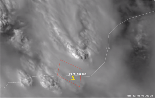
Bill Line published a blog post titled “Colorado Tornado, Parallax, and 30-sec Imagery”. The post discusses GOES partially overlapped mesoscale sector 30-second imagery, as well as parallax, using a tornadic Colorado storm as the example. The link to the post can be found here. (POC: B. Line, CoRP/RAMMB, bill.line@noaa.gov) Funding: PDRA
Figure. GOES-West 30-second visible imagery captured the tornadic storm near Fort Morgan, CO. Overlay of NWS Warning polygon and Local Storm Report with respect to thunderstorm updraft top helps to characterize degree of parallax in this situation.
Download Weekly Report (PDF)Posted on: July 8, 2022
Page Contact
Unless otherwise noted, all content on the CIRA RAMMB: VISIT, SHyMet and VLab webpages are released under a Creative Commons Attribution 3.0 License.