
Synthetic GXI Imagery
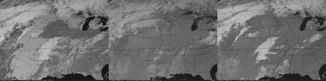
The GXI instrument on the upcoming GeoXO satellite will have a channel near 0.91 µm, which is sensitive to water vapor. When combined with the 0.86 µm window, a product highlighting daytime water vapor can be constructed. In preparation for the new satellite, CIRA creates synthetic satellite imagery by running the CRTM using output from the NSSL-WRF model. The CRTM distribution includes files containing surface land type data that is used to provide surface albedo and emissivity information. The information provided by those files is rather coarse, however, and results in a rather unrealistic looking image. As an alternative, the CRTM allows the user to provide surface albedo or emissivity from a different source. By using albedos from a simple cloud-clearing technique, the appearance of the synthetic imagery can be vastly improved. The figure demonstrates this improvement. The center panel contains the actual GOES-19 0.865 µm image from 1900 UTC 14 November 2025. The left panel contains the corresponding synthetic image with the surface albedo determined from the USGS land use information provided with the CRTM package. The coarse structure of the surface albedo is apparent in the clear regions. The right panel contains the same CRTM run but with the surface albedo determined from the cloud-cleared image. For each satellite footprint the cloud-clearing technique uses the second darkest pixel from the set of 31 daily 1900 UTC images ending on 14 November. The second darkest pixel is chosen to remove any cloud shadows that may be present. With this technique, surface features such as lakes and rivers are clearly present, as well as the varying albedos indicative of the differing land cover. CIRA plans to demonstrate the capabilities of GeoXO using synthetic imagery at this year’s Hazardous Weather Testbed. (J. Dostalek, J. Haynes, M. Rogers, and S. Miller, CIRA; jack.dostalek@colostate.edu; john.haynes@colostate.edu; matthew.rogers@colostate.edu; steven.miller@colostate.edu; Funding: GeoXO)
Updated Statistical-Dynamical Tropical Cyclone Models made available to the National Hurricane Center: Improvements were made to several statistical-guidance tropical cyclone forecast models and made available to NHC. Improvements include model retraining with updated datasets, adding forecasts from Artificial Intelligence Weather Prediction (AIWP) as input to consensus models, replacing legacy McIDAS GOES input data with NetCDF GOES data, and making the diurnally-corrected GOES-blended SST and the NESDIS Oceanic Heat Content (OHC) products the primary source of ocean data. NHC plans to transition the updated models to operations on the WCOSS supercomputer for the 2026 Hurricane Season. (POCs: M. DeMaria, J. Martinez, G. Chirokova, A. Brammer and K. Musgrave, CIRA, MarkDeMaria@colostate.edu, Jon.Martinez@noaa.gov, Galina.Chirokova@colostate.edu, Alan.Brammer@colostate.edu, Kate.Musgrave@colostate.edu , funding NWS/STI, GOES)
Download Weekly Report (PDF)Posted on: March 13, 2026
Page Contact
Unless otherwise noted, all content on the CIRA RAMMB: VISIT, SHyMet and VLab webpages are released under a Creative Commons Attribution 3.0 License.