
Terrain-corrected ABI Fire Imagery on RealEarth
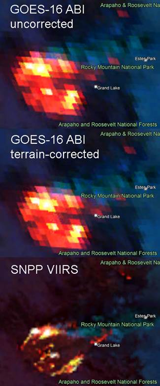
CIRA has been delivering VIIRS Fire Temperature RGB and VIIRS Day Fire RGB imagery in geoTIFF format to CIMSS’ RealEarth website since 2020. In January 2023, delivery of these products from GOES-16 and GOES-18 ABI for the CONUS and Meso sectors began. Last week, the ABI products were upgraded by including terrain-corrected geolocation information that was recently developed by CIMMS for use with ABI. The VIIRS products have always been produced with terrain-correction by default, as the JPSS ground system provides terrain-corrected geolocation files operationally. In the mountains of the western US, the parallax effects of high terrain can lead to location errors of 5 km or more in ABI imagery, if uncorrected, and these errors have a significant impact on fire detection, monitoring and mitigation efforts. The figure below shows remapped Fire Temperature RGB imagery from both ABI and VIIRS for the East Troublesome Fire -the second largest fire in Colorado’s history- which occurred in the late summer and autumn of 2020. Note the placement of the fire in the ABI images between the uncorrected and corrected ABI images, particularly in the vicinity of Grand Lake. Links to the CIRA-produced geoTIFFs are available at the following URL: https://realearth.ssec.wisc.edu/products/?collection=NGFS# (POC: C. Seaman, CIRA; S. Batzli and C. Schmidt, CIMSS; curtis.seaman@colostate.edu; sabatzli@wisc.edu; chris.schmidt@ssec.wisc.edu) Funding: DSRA
Download Weekly Report (PDF)Posted on: March 10, 2023
Page Contact
Unless otherwise noted, all content on the CIRA RAMMB: VISIT, SHyMet and VLab webpages are released under a Creative Commons Attribution 3.0 License.