
2026 AMPS Meeting: LEO Satellite Workshop
Improving Arctic Forecasts with LEO Weather Satellite Data
Learn about the unique benefits of Low-Earth Orbit (LEO) weather satellite data in this hands-on, 2-hour training session on Wednesday, March 25, 2026 and Thursday, March 26, 2026. Taught by NOAA satellite product trainers, this free event will demonstrate how LEO data can enhance operational forecasting and research in the Arctic. Operational weather forecasters and researchers from all backgrounds are welcome; participants should bring a laptop. This workshop is supported by the NOAA Office of Low Earth Orbit Observations. Attendees are encouraged to bring their laptops if they have one, some will be available for loan.
LEO Satellite Workshop – Presentation Slides (includes all sessions)
Wednesday, 25 March 2026 – Agenda
1445-1455 AKDT —- Welcome to UAF (Dr. Nettie LaBelle-Hamer, Geophysical Institute Deputy Director)
1455-1500 AKDT —- Introduction to NOAA LEO Program (William Straka, CIMSS)
1500-1505 AKDT —- Introduction to Alaska Direct Broadcast (Jen Delamere, GINA)
1505-1535 AKDT —- Visible Infrared Imaging Radiometer Suite (VIIRS) (Jorel Torres, CIRA/CSU)
- CIRA SLIDER – JPSS Northern Hemisphere Sector and Quick Guides: VIIRS DNB, GeoColor, and Snow/Cloud Layers.
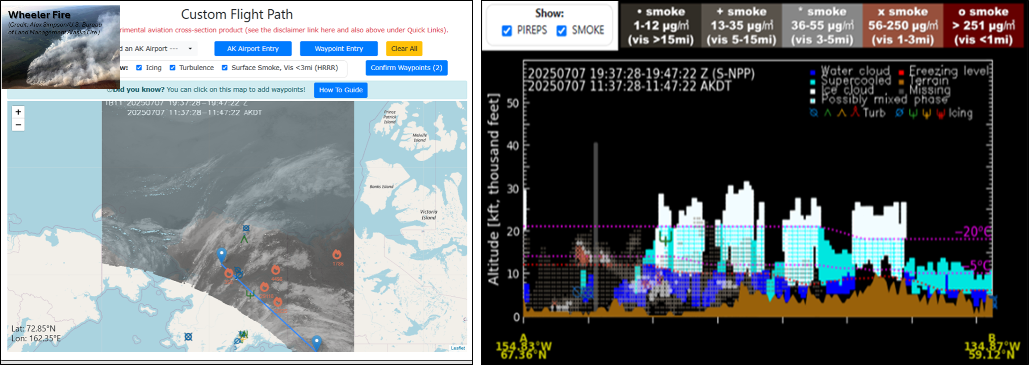
- CIRA Aviation – Create Custom Satellite Cloud Vertical Cross Sections. Quick Guide: Satellite Cloud Vertical Cross-sections. 4-week Archive.
- Alaska Smoke Example – Satellite Cross Section
1535-1605 AKDT —- NUCAPS (Tim Wagner, CIMSS)
1605-1635 AKDT —- Microwave (Carl Dierking, GINA)
1635-1645 AKDT —- Closing Remarks (Jen Delamere, GINA, and William Straka, CIMSS)
Thursday, 26 March 2026 – Agenda
1310-1320 AKDT —- Welcome to UAF (Dr. Nettie LaBelle-Hamer, Geophysical Institute Deputy Director)
1320-1325 AKDT —- Introduction to NOAA LEO Program (William Straka, CIMSS)
1325-1330 AKDT —- Introduction to Alaska Direct Broadcast (Jen Delamere, GINA)
1330-1400 AKDT —- Visible Infrared Imaging Radiometer Suite (VIIRS) (Jorel Torres, CIRA/CSU)
- CIRA SLIDER – JPSS Northern Hemisphere Sector and Quick Guides: VIIRS DNB, GeoColor, and Snow/Cloud Layers.
- CIRA Aviation – Create Custom Satellite Cloud Vertical Cross Sections. Quick Guide: Satellite Cloud Vertical Cross-sections. 4-week Archive.
- Alaska Smoke Example – Satellite Cross Section
1400-1430 AKDT —- NUCAPS (Tim Wagner, CIMSS)
1430-1500 AKDT —- Microwave (Carl Dierking, GINA)
1500-1510 AKDT —- Closing Remarks (Jen Delamere, GINA, and William Straka, CIMSS)
Additional Satellite Training Resources and Materials
VISIT – JPSS and GOES Quick Guides and Quick Briefs. GINA – JPSS Quick Guides. Satellite Foundational Course for JPSS (SatFC-J).
VISIT Teletraining Calendar. Satellite Blogs. JPSS/LEO Imagery for Users webpage. Satellite Book Club (SBC) Seminars.
Page Contact
Unless otherwise noted, all content on the CIRA RAMMB: VISIT, SHyMet and VLab webpages are released under a Creative Commons Attribution 3.0 License.